Monumental Questions - Can I still get Poison Oak in the Winter?

Kristie Ehrhardt • February 6, 2025


YES!


Leaves of three - let them be. Right but it’s winter and what if there are no leaves? 


Poison Oak (Toxicodendron diversilobum), Pacific Poison Oak or Western Poison Oak is a widely distributed woody shrub or vine that belongs to the Sumac (Anacardiaceae) family. The Sumac family is also known as the Cashew family which contains the tree that gives us that delightful buttery nut (it’s actually a seed) as well as the tree that provides mouthwatering mangos and the tree that produces savory pink peppercorns. How can such a delectable family also give us such an annoying plant? 


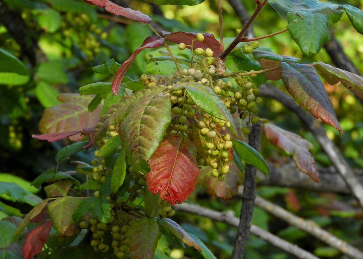
Poison oak (PO) is not even remotely related to oaks but the leaves sort of resemble oak leaves. They are divided into three leaflets that are about one and a half to four inches long. The species name, diversilobum, refers to the diversity of leaf size and shape; the edges can be toothed, scalloped or lobed and vary greatly. PO is deciduous and the new leaves are usually dark golden or bronze when they are just beginning to unfold in early to mid-spring. They turn a bright then darker glossy green and ultimately transitioning a stunning scarlet red then fading to pink in late summer and fall. The small flowers are greenish-white and appear in late spring to mid-summer and if they are fertilized they become small creamy white berries. Growth forms vary depending on where it is occurring, but it thrives in full sun as well as shady environments. In open sunlight it can grow as a tall, dense shrub or tree with a thick trunk, or a woody vine winding around and up into the canopy of tall trees, fences and other vegetation. In shady areas it can occur as a dense thicket, vine or anything in between. It is prolific and spreads by seed dispersal and through underground rhizomes.


It is widely distributed in Western North America from British Columbia, Washington, Oregon, California, Nevada and Baja Mexico and occurs extensively throughout the Berryessa Snow Mountain National Monument. It occurs in chaparral and woodland habitats as well as coastal sage scrub, grasslands, oak woodlands and mixed evergreen forests below 5,000 feet. It’s a common understory plant in riparian corridors and grows alongside Giant and Coastal Redwoods. PO is even a constant quagmire in dry-farmed mountain orchards, urban parks and recreation areas. In fact, it’s kind of hard to find a biome in the Central Valley of California that doesn’t support Poison Oak unless you go into the Great Basin or the southwestern edge of the Mojave desert.


The genus Toxicodendron contains many plants that cause allergic reactions. The oil of the plants contains a compound called Urushiol that causes the reaction and it is found in all parts of the plant except the pollen (ironic!). Direct contact with the plant or anything that has touched the plant such as clothing, pets, tools or vehicles can result in painful, itchy blisters. Not everyone is allergic to it, however, repeated exposure can lead to heightened sensitivity. If an area dense with PO is burning, inhaling the smoke can cause a severe internal reaction.


Which leads me to why you can still have a reaction to PO in the winter after all the leaves have fallen. It’s a lot harder to spot when it’s just a twig, branch or bare vine along the edge of the trail. Twigs and stems still contain the oil that produces reactions and you may not even realize that you’ve brushed up against it until it’s too late. Keep an eye out for exposed, reddish-brown whip-like sticks coming out of the ground, especially if you know you’re in an area where PO is present. Sometimes the berries remain on the plant even though the leaves have fallen off and occasionally the stems show black marks where the sap may have oozed out and dried. If you know you’ve been in contact with PO, washing your exposed skin with dish soap is a great way to remove the oil from your skin and washing your clothes as soon as you can so you don’t transfer the oil to yourself, others or additional laundry is also a good idea. If your pets have been scampering about where PO could be present, give them a good bath before you snuggle up with them and consider wearing long rubber gloves like those made for doing dishes to avoid the oils transferring to you.


PO isn’t all bad; Black-tailed Deer, California Ground Squirrels and Western Gray Squirrels among other species consume the leaves of the plant which is rich in phosphorus, calcium and sulfur. Many birds eat the berries and utilize the plant for shelter. Research has shown that livestock, domestic dogs and other native wildlife species do not have adverse reactions to Urushiol. Native Americans cooked with it, used the stems to make baskets and used the juice from the fruit to dye materials black.


Don’t stay off the trail, just take precautions and enjoy winter hiking in your favorite monument! 


-Kristie Ehrhardt (kehrhardt@tuleyome.org)

Tuleyome Land Conservation Program Manager

RECENT ARTICLES

By Bryan Pride February 11, 2026
In 2020, Governor Newsom committed California to an ambitious goal: conserve 30% of our lands and coastal waters by 2030. This “30x30” initiative isn’t just about setting aside more protected areas; it’s a comprehensive strategy to protect biodiversity, expand equitable access to nature, and build resilience to climate change across California’s diverse landscapes and waters. California has made meaningful progress towards the 30x30 goal. Currently, 24.4% of our lands and 16.2% of coastal waters meet the 30x30 conservation criteria, defined as areas that are durably protected and managed to sustain functional ecosystems and the diversity of life they support. But with less than five years remaining, we still need to conserve millions of additional acres to reach this critical goal. The Power In Nature Coalition No single organization can achieve 30x30 alone. That’s why Tuleyome is a proud member of the Power In Nature Coalition; a network made powerful by the collective work of over 250 community groups, conservation organizations, land trusts, and Indigenous organizations working together to conserve and protect the diverse landscapes of California. This statewide network coordinates advocacy, identifies priority conservation projects , and ensures that 30x30 implementation protects biodiversity, fosters meaningful relationships, and partners with state agencies and diverse communities. Power In Nature works on multiple fronts: defending conservation funding in state budgets, identifying potential 30x30 projects across California, and advocating for policies that support rather than undermine conservation progress. Power In Nature has multiple regional groups to elevate geographical priorities and empower local organizations to connect state-level policy to on-the-ground conservation work in their communities. Tuleyome’s Role in Advancing 30x30 At Tuleyome, our work protecting the Berryessa Snow Mountain National Monument directly contributes to California’s 30x30 goals. We’re actively engaged with Power In Nature’s Sacramento Valley regional group, as well as the Far North and Bay Area regional groups, helping coordinate conservation efforts across our region and connecting local priorities to statewide advocacy. Tuleyome has also participated in Power In Nature Advocacy Days, where we met with state elected officials to discuss policies and legislation that further or hinder the 30x30 conservation goals. How You Can Support 30x30 Whether you’re a landowner, community member, or fellow conservation advocate, there are many ways you can support 30x30 progress. There are multiple qualifying conservation lands that have not been added to the Conserved Areas Explorer and this is one of the many ways people can get involved to help track areas protected. If you’re interested in learning more about 30x30 activities in your region, check out the Power In Nature regional groups and sign up to attend monthly regional meetings or gain access to Power In Nature’s newsletter. Most importantly, through Power In Nature, you can make your voice heard by participating in local advocacy days or contacting your state legislators to encourage their support for full funding to conservation agencies and protection of environmental review processes. California’s commitment to conserve 30% of our lands and waters by 2030 is achievable, but only if we work together to make it a reality. If you have questions about how to get involved with 30x30 or Power In Nature, don’t hesitate to reach out! Bryan Pride Tuleyome Policy Director
By Kristie Ehrhardt February 11, 2026
You might already know that the Berryessa Snow Mountain National Monument (Monument) is a wonderland for birdwatchers. With a range of habitat types from aquatic, riparian, native grassland, oak woodlands, conifer forests to subalpine the range of species found in the Monument is staggering. If you prefer to break it down by county rather than habitat, western Colusa County boasts a birders paradise in Bear Valley and Lake County offers the shores of Clear Lake. Napa County showcases Quail Ridge Reserve and Lake Hennessey. Yolo County puts forth a plethora of hot spots including Putah Creek, Lake Solano, and the Cache Creek preserve which is home to Bald and Golden Eagles, Osprey and others! And, this is just a smattering of the treasure trove for bird nerds to enjoy in the nearly 345,000 publicly accessible acres of Monument. But, how do you know where and when to go to see what? Even if you’re an experienced birder, it can be overwhelming to know where and when to begin. I know people that travel to different states to check birds off of their “life list”. I also know people, some of them are those same people, that travel all over the globe to get a glimpse of a rare bird - or maybe it’s just rare to someone from Sacramento. Either way it’s enticing and rewarding to be part of a community with a common interest. There’s almost a secret code between birders. There’s definitely a code to name abbreviations and a spiffy way to keep count if you’re recording them. There’s also a way to estimate the number of birds in a flock but if you’re just wanting to sneak up on a feathered friend near or far, how do you know where to start? Try downloading the Cornell Lab eBird app. The app lets you input your own findings as well as investigate other people’s observations. You can base your search on your location or use a near or far location that you’d like to go explore. Or, you can browse by species and see exactly where to go to find them. The eBird app uses citizen science and operates similarly to the iNaturalist app, a favorite among biologists, naturalists and other interested folks. With the eBird app, you can contribute your sightings or even sound recordings to the community platform making it the largest birding community in the world. You can also create your own lists and have the app track them for you. The app not only makes birding more inclusive and interesting for individual birders but it is beneficial for the network of scientists as well. The combined data from the app helps conservationists understand how numbers of birds shift as well as aiding in developing genetic species distribution models that show where and when birds are in the region. This information helps develop and establish better conservation strategies for individual species and collective populations of birds. The app is easy, fun and rewarding for novice and veteran birders, conservationists, scientists and ultimately the birds themselves.
By Kristie Ehrhardt February 11, 2026
The Capay Valley Almond Festival has been a regional tradition since 1915. It showcases the Esparto/Capay Valley region and was originally held in the fall after the almond harvest was complete. Years later it was rescheduled to occur on the last Sunday in February to celebrate the almond trees while in blossom. The Almond Festival is the only local celebration that not only incorporates the dazzling landscape but it also honors five Capay Valley towns: Esparto, Capay, Brooks, Guinda and Rumsey. The 21-mile route along Highway 16 covers each town, offering their own unique ambiance and activities all while celebrating the almond bloom in Yolo County. You will also find local crafts, family fun, delicious food and other entertainment at each location. A bit about California’s almond history! Much like the European Starling’s initial introduction into the United States, the first attempt at almond production in California was not as glorious as anticipated. Almond trees were first planted in California as early as 1853 using European varieties that were not adapted for our climate conditions. Most of these subpar trees were either converted into other fruit trees or used for firewood. Even though the inaugural attempt wasn’t fruitful (haha, get it?), lessons were learned about cross pollination and where to plant the next go-around. Science happened and by the 1880’s other varieties were being cultivated and during the Citrus Fair in 1886, the two varieties that are still grown today were introduced. By the 1900’s cross pollination tactics advanced and were in place and our commercial production was on its way. This combined with the fact that almond trees were productive in soils that were too sandy for other fruit trees and could be prolific without the use of much artificial water, the crop finally seemed to be destined for success. During the twenty year span between the mid 1960’s and the mid 1980’s, irrigation methods advanced and became more available to land in the San Joaquin Valley, which held ideal conditions for almond production, creating a booming industry that still remains today. In 2020, 1.25 million acres of California were in almond production. We yield 2.8 BILLION (!) pounds of almonds which provides 100% of the United States commercial supply and over 80% of the world’s demand. Almonds are in the top five most valuable California exports bringing in almost five billion dollars.