Monumental Questions - The Antiquities Act and Berryessa Snow Mountain National Monument

Kristie Ehrhardt • April 7, 2024

President Theodore Roosevelt signed the Antiquities Act into law on June 8, 1906 cementing the public’s interest in protecting cultural artifacts and natural resources of historic or scientific interest (antiquities) on Federal lands. The purpose of the Antiquities Act was to preserve public natural areas as parks or conservation lands, prohibiting destruction of these sites. Over the past 116 years, the Act has been used over 150 times by presidents on both sides of the political line to establish new National Monuments and expand those previously designated. Teddy Roosevelt himself used the Antiquities Act 18 times but President Barack Obama holds the record with 26 new National Monuments established during his presidency.


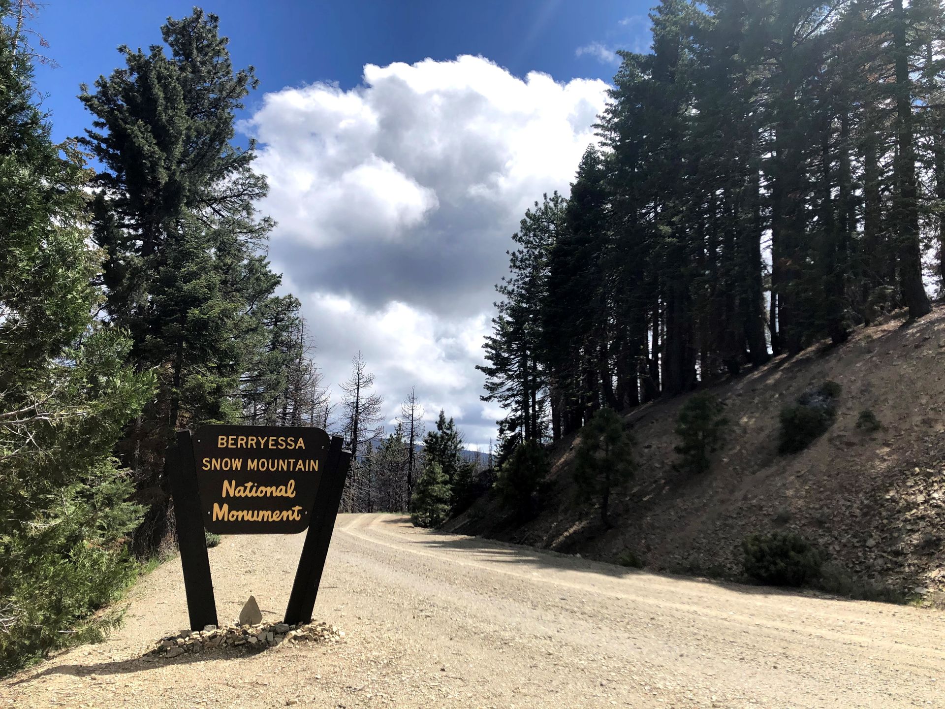
The Berryessa Snow Mountain National Monument (Monument) was established by President Barack Obama on July 10, 2015 under the Antiquities Act. The Monument encompasses 330,780 acres and is jointly managed by both the U.S. Department of Interior’s Bureau of Land Management (133,576 acres) as well as the United States Forest Service, Mendocino National Forest (197,204 acres); each agency managing their designated acreage within the Monument boundaries. The Monument includes three wilderness areas (Snow Mountain, Cache Creek and Cedar Roughs), one Wild and Scenic River (Cache Creek) and five Areas of Critical Environmental Concern. Now, we look to the Berryessa Snow Mountain National Monument Expansion Act, H.R. 6366/S. 4080, that would add the Lake County portion of Walker Ridge, known as Condor Ridge or Molok Luyuk in Patwin, to the Berryessa Snow Mountain National Monument.


For the previous 11,000 years, the Berryessa Snow Mountain National Monument region has been home to many tribes including the Yuki, Nomlaki, Patwin, Pomo, Huchnom, Wappo, Lake Miwok, and Wintun, making the it one of the most linguistically and culturally diverse areas in California. The addition of Molok Luyuk/Walker Ridge/Condor Ridge to the Monument will ensure that federally recognized tribes can co-manage and steward the land with their federal partners. As part of H.R. 6366/S. 4080, Walker/Condor Ridge will be renamed Molok Luyuk which honors its cultural significance, just as the Antiquities Act was intended to do.


Often called a Biological Hot Spot because the elevation, topography and geology of the Berryessa Snow Mountain National Monument region vary so greatly and create many different habitat types. The Monument provides some of the most scenic and most biologically diverse landscapes in California including Blue Oak Woodland and chaparral in the lower elevations which transition into intermediate vegetation communities that includes mixed conifers. True fir, Jeffrey pines and incense cedar are found at higher elevations along with exposed unvegetated rock outcrops. The Snow Mountain area is known as one of the richest, most biologically diverse areas in California. The extraordinary geologic history of the area also plays an essential role in the unique array of plants. The serpentine soils found here have distinct chemical and physical properties and plants that grow there are highly adapted to this high iron, low organic content environment. Because serpentine soils are rare, so are the plants that are able to survive in them. Serpentine soils are not found in many places in the United States and California boasts having the majority of them. Many of the serpentine plant species are endemic, meaning they don’t occur anywhere else, and are listed as special-status species.


The Berryessa Snow Mountain Expansion Act would be the a very fitting 116th anniversary celebration for the Antiquities Act.


-Kristie Ehrhardt; kehrhardt@tuleyome.org


Tuleyome Land Conservation Program Manager

RECENT ARTICLES

June 5, 2025
We extend our thanks and gratitude to Stephen McCord as he ends his tenure on the Tuleyome Board of Directors. Stephen has applied his energy and expertise to fulfilling Tuleyome’s mission for many years. In 2016 he managed the first Tuleyome mercury mine remediation project at the Corona/Twin Peaks Mine. He followed that with work on Tuleyome trail projects in the Knoxville Off-Highway Vehicle Area, riding all the trails on his own adventure motorcycle. As a Tuleyome representative, he’s taken many community members on hikes in Berryessa Snow Mountain National Monument and the surrounding areas. Stephen has over 20 years of environmental engineering experience, in California and worldwide. He has overseen extensive projects in water quality field work, management and cleanup, and has applied his knowledge to policy development, analysis and technical support. In short, Stephen is a consummate environmental and water engineer, and he brought his expertise to Tuleyome’s many projects. In 2023 Stephen joined the Board of Directors and agreed to serve as President. He applied his supreme organizational skills to managing board duties and activities. He also brought an optimism to the board about what can be accomplished with foresight, good planning and collaboration. Stephen has been a tireless advocate for Tuleyome, keeping the board on task even while handling numerous other professional responsibilities. Fortunately, although he is stepping down from the board, he will continue to support Tuleyome’s mission in many other ways. -Kim Longworth, Lyndsay Dawkins and Bill Grabert Volunteer Tuleyome Board members 
By Geoff Benn June 5, 2025
A river otter making its way up the slide. Looking to take a break with some cute video content? This month we placed game cameras looking into an otter slide at Conaway Ranch. Otter slides are paths worn into riverbanks by repeated use by otters and other animals. The slides at Conaway are quite active, so we’ve been able to get some great footage, including otters, beavers, racoons, snakes, and more! 
By Bryan Pride June 5, 2025
Since April 2024, America's public lands had something they'd never had before: a rule that treated conservation as equal to all other land uses. The Public Lands Rule , introduced by the Biden Administration, formally recognized conservation as a legitimate practice of multiple use, putting conservation on equal footing with recreation, grazing, and resource extraction. Built on decades of management experience and guided by science, data, and Indigenous knowledge, it gives land managers tools to maintain healthy ecosystems while supporting all the diverse ways we depend on public lands. It acknowledges a simple truth: conservation must be valued equally to all other land uses. Now there is growing pressure to rescind it. Why This Matters The environment around us is free-flowing, it's not confined to state borders or county lines. When mining operations contaminate watersheds in Northern California, it impacts the local businesses who depend on healthy rivers downstream, the agricultural communities that rely on clean water, and the families who've been camping along those waterways for generations. The Public Lands Rule recognized this interconnected reality and gave land managers agency to address problems before they spread across California's diverse landscapes, protecting the long-term viability of grazing allotments, recreation areas, and rural livelihoods that all depend on healthy public lands. This interconnected reality is exactly why the Public Lands Rule matters. The Rule is designed to ensure that the places we depend on, whether for weekend camping trips, or cattle grazing, stay healthy enough to support these uses long-term. When an area becomes overgrazed and doesn't recover, access to those grazing allotments is permanently lost, reducing ranchers' ability to maintain their livelihoods and harming local food production. Poor use or overuse of our public lands creates ripples of negative impact that hurt all communities. The Rule's main objective is simple but revolutionary: make sure our public lands stay productive for everyone who depends on them, rather than degrade them. The Rule created practical tools that built in accountability and prioritized future generations' access to healthy public lands. Restoration Leases : 10-year agreements allowing a variety of entities such as, conservation groups, tribes, and nonprofits to restore damaged landscapes—fires restoration, restoring wildlife habitats and cleaning up abandoned mining sites that currently scar some of our most beautiful public lands. Mitigation Leases : A tool that allows land users or other entities to offset impacts from their activities over specified time periods, creating partnerships between different land users and conservation groups to address environmental impacts on public lands. Strengthened Protection for Critical Areas : Clearer guidelines for protecting Areas of Critical Environmental Concern—the most special and fragile places that often provide the best wildlife viewing, the cleanest water sources, the most pristine camping experiences and the richest biodiversity. The False Dichotomy: Multiple Use vs. Conservation The main argument being used to encourage the rollback of the Public Lands Rule is " multiple use ", the legal principle requiring Bureau of Land Management (BLM) lands to serve many different purposes. The current Administration claims the Public Lands Rule hinders multiple uses of public lands. Why? The Rule calls for restoring degraded areas and making science based decisions. Contrary to their actual meaning, the current Administration interprets "restoring" and "science based decisions" as "locking up land". Land locking, where access gets completely cut off, is a real concern in some areas—it prevents both recreation and grazing. However, land locking is not what the Public Lands Rule promotes. In reality, it is promoting land healing. Take grazing for example. The Rule empowers BLM to use restoration leases in conjunction with existing grazing permittees to restore degraded rangeland. Monitoring who is grazing where and the number of permits issued for specific areas is a means to ensure sustainable grazing and prevent overuse. Many ranchers and land managers supported the Rule because they understand that healthy land is productive land. Overgrazing and environmental damage hurt their livelihoods too. The same principle applies to fire recovery. When public lands are damaged by sweeping wildfires, there is a need for active restoration: replanting native vegetation, stabilizing soils, removing hazardous debris. Restoration has to take place before safe recreation, grazing and other uses can resume. At times, restoration requires temporarily limiting access to burned areas as they recover. The goal is to allow for our lands to recover and heal before we start depending on them again with our multiple uses. Land restoration is not just limited to grazing or extraction; it is essential for recovering from wildfires. Whether it's grazing, recreation, or extraction, the Public Lands Rule isn't about stopping these uses, it's about understanding that healthy ecosystems are prerequisites for multiple use, not obstacles to it. You can't have sustainable grazing on degraded rangeland, quality recreation in fire damaged landscapes, or responsible extraction without considering long-term impacts We Are Public Stewards The Public Lands Rule represents a historic shift in how we value conservation, its potential rollback is a setback. But the vision it represents, conservation as a form of legitimate multiple use, remains essential and is not gone. As stewards of these 245 million acres, we have the power to practice conservation in our own actions and advocacy. Every time we practice Leave No Trace, support local businesses that operate responsibly on public lands, and make our voices heard in land management decisions, we're building the foundation for balanced stewardship that benefits everyone. Our public lands belong to all of us, which means we each have the power, and responsibility, to be good stewards of the lands we love. -Bryan Pride ( bpride@tuleyome.org ) Certified California Naturalist Policy Director