Monumental Questions - What are the best trails for wildflower viewing in the Berryessa Snow Mountain National Monument?

Nate Lillge • March 16, 2022

Snow Mountain Wilderness Wildflowers

Every January through May, the hillsides of Berryessa Snow Mountain National Monument become brilliant with color. Slopes many miles away appear orange with California Poppies (Eschscholzia californica) while close inspection of the ground at one’s feet shows many smaller, less noticeable flowers like common fringe pod (Thysanocarpus curvipes). Combined with the perfect temperatures this time of year, now is your chance to get out and enjoy the color and beauty! Here are some of our favorite trails for wildflower spotting.


Pope to Putah: This trail is located west of Lake Berryessa near Pope Valley. The trail winds through chaparral before entering oak woodland near Putah Creek. Warrior’s plume (Pedicularis densiflora), Indian paintbrush (Castilleja affinis), and golden fairy lanterns (Calochortus amabilis) are common in chaparral while poppies (Eschscholzia spp.) and mosquito bills (Primula hendersonii) are abundant in the oak woodland.


Stebbins Cold Canyon: While not included within the boundaries of the monument Stebbins Cold Canyon is surrounded by monument lands and is one of the closest access points to the monument. This is a very popular hiking area – hiking during the week or starting early on the weekend is the best way to avoid the crowds. This time of year it is easy to see why it is so popular – wildflowers, more wildflowers, and views. Western redbud (Cercis occidentalis), lupine (Lupinus spp.), and poppies (Eschscholzia spp.) dominate the display but there are many other species to enjoy. Woodland star (Lithophragma affine), Fremont’s death camas (Toxicoscordion fremontii), and mule’s ears (Wyethia glabra) are common.


Road 53: Heading into the hills west of Guinda, County Road 53 takes hikers through open grassland and into a riparian ecosystem before chaparral takes over. Manroot (Marah fabacea), larkspur (Delphinium sp.), California bee plants (Scrophularia californica), and checker lilies (Fritillaria affinis) are visible along with purple owl’s clover (Castilleja exserta) and many species of lupine (Lupinus spp.).


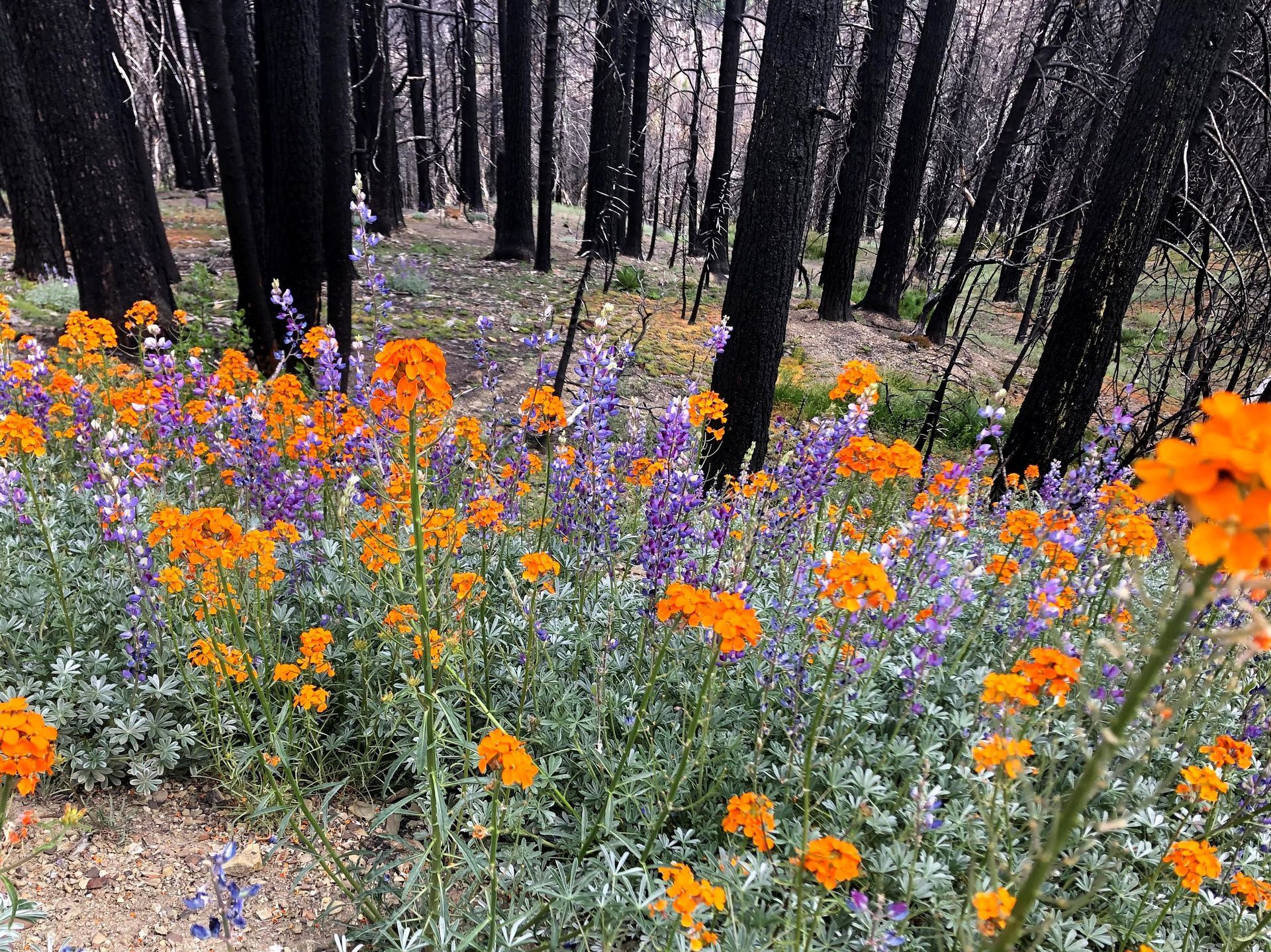
Redbud Trail: This is a relatively easy hike that provides a wide variety of ecosystems: oak woodland, chaparral, riparian. The wide variety of flowers one sees along this trail makes it worth the trip to the trailhead. Bird’s-eye (Gilia tricolor), warrior’s plume (Pedicularis densiflora), wallflower (Erysimum capitatum), larkspur (Delphinium sp.) and lupine (Lupinus sp.) are common.


Bear Valley: Bear Valley, located north of CA-20, is known for its amazing wildflower displays. Cream cups (Platystemon californicus), goldfields (Lasthenia spp.), fiddlenecks (Amsinckia spp.) and MANY more. When making the trip to Bear Valley, do not forget to look along the roadside on the drive in. You may see mariposa lilies (Calochortus luteus), bunchleaf penstamen (Penstemon heterophyllus), and tidytips (Layia sp.).


West Crockett Trailhead: This trailhead is at a higher elevation and located on the northern side of Snow Mountain Wilderness which means that it typically blooms later in the season than the rest of the monument. Flowers one can expect to see on this trail are columbine (Aquilegia sp.), red larkspur (Delphinium nudicaule), and large camas (Camassia leichtlinii).


These are just some of the trails you can explore to enjoy the flowers. Check out Tuleyome's trail guide which has details about many trails in the region, all of which have great wildflowers.


We hope you get out and enjoy the amazing wildflowers in Berryessa Snow Mountain National Monument. Feel free to share your photos of wildflowers with us by tagging us on Facebook, Twitter, and Instagram!


-Nate Lillge; nlillge@tuleyome.org


Adventures and Engagement Director


Certified California Naturalist

RECENT ARTICLES

By Bryan Pride February 11, 2026
In 2020, Governor Newsom committed California to an ambitious goal: conserve 30% of our lands and coastal waters by 2030. This “30x30” initiative isn’t just about setting aside more protected areas; it’s a comprehensive strategy to protect biodiversity, expand equitable access to nature, and build resilience to climate change across California’s diverse landscapes and waters. California has made meaningful progress towards the 30x30 goal. Currently, 24.4% of our lands and 16.2% of coastal waters meet the 30x30 conservation criteria, defined as areas that are durably protected and managed to sustain functional ecosystems and the diversity of life they support. But with less than five years remaining, we still need to conserve millions of additional acres to reach this critical goal. The Power In Nature Coalition No single organization can achieve 30x30 alone. That’s why Tuleyome is a proud member of the Power In Nature Coalition; a network made powerful by the collective work of over 250 community groups, conservation organizations, land trusts, and Indigenous organizations working together to conserve and protect the diverse landscapes of California. This statewide network coordinates advocacy, identifies priority conservation projects , and ensures that 30x30 implementation protects biodiversity, fosters meaningful relationships, and partners with state agencies and diverse communities. Power In Nature works on multiple fronts: defending conservation funding in state budgets, identifying potential 30x30 projects across California, and advocating for policies that support rather than undermine conservation progress. Power In Nature has multiple regional groups to elevate geographical priorities and empower local organizations to connect state-level policy to on-the-ground conservation work in their communities. Tuleyome’s Role in Advancing 30x30 At Tuleyome, our work protecting the Berryessa Snow Mountain National Monument directly contributes to California’s 30x30 goals. We’re actively engaged with Power In Nature’s Sacramento Valley regional group, as well as the Far North and Bay Area regional groups, helping coordinate conservation efforts across our region and connecting local priorities to statewide advocacy. Tuleyome has also participated in Power In Nature Advocacy Days, where we met with state elected officials to discuss policies and legislation that further or hinder the 30x30 conservation goals. How You Can Support 30x30 Whether you’re a landowner, community member, or fellow conservation advocate, there are many ways you can support 30x30 progress. There are multiple qualifying conservation lands that have not been added to the Conserved Areas Explorer and this is one of the many ways people can get involved to help track areas protected. If you’re interested in learning more about 30x30 activities in your region, check out the Power In Nature regional groups and sign up to attend monthly regional meetings or gain access to Power In Nature’s newsletter. Most importantly, through Power In Nature, you can make your voice heard by participating in local advocacy days or contacting your state legislators to encourage their support for full funding to conservation agencies and protection of environmental review processes. California’s commitment to conserve 30% of our lands and waters by 2030 is achievable, but only if we work together to make it a reality. If you have questions about how to get involved with 30x30 or Power In Nature, don’t hesitate to reach out! Bryan Pride Tuleyome Policy Director
By Kristie Ehrhardt February 11, 2026
You might already know that the Berryessa Snow Mountain National Monument (Monument) is a wonderland for birdwatchers. With a range of habitat types from aquatic, riparian, native grassland, oak woodlands, conifer forests to subalpine the range of species found in the Monument is staggering. If you prefer to break it down by county rather than habitat, western Colusa County boasts a birders paradise in Bear Valley and Lake County offers the shores of Clear Lake. Napa County showcases Quail Ridge Reserve and Lake Hennessey. Yolo County puts forth a plethora of hot spots including Putah Creek, Lake Solano, and the Cache Creek preserve which is home to Bald and Golden Eagles, Osprey and others! And, this is just a smattering of the treasure trove for bird nerds to enjoy in the nearly 345,000 publicly accessible acres of Monument. But, how do you know where and when to go to see what? Even if you’re an experienced birder, it can be overwhelming to know where and when to begin. I know people that travel to different states to check birds off of their “life list”. I also know people, some of them are those same people, that travel all over the globe to get a glimpse of a rare bird - or maybe it’s just rare to someone from Sacramento. Either way it’s enticing and rewarding to be part of a community with a common interest. There’s almost a secret code between birders. There’s definitely a code to name abbreviations and a spiffy way to keep count if you’re recording them. There’s also a way to estimate the number of birds in a flock but if you’re just wanting to sneak up on a feathered friend near or far, how do you know where to start? Try downloading the Cornell Lab eBird app. The app lets you input your own findings as well as investigate other people’s observations. You can base your search on your location or use a near or far location that you’d like to go explore. Or, you can browse by species and see exactly where to go to find them. The eBird app uses citizen science and operates similarly to the iNaturalist app, a favorite among biologists, naturalists and other interested folks. With the eBird app, you can contribute your sightings or even sound recordings to the community platform making it the largest birding community in the world. You can also create your own lists and have the app track them for you. The app not only makes birding more inclusive and interesting for individual birders but it is beneficial for the network of scientists as well. The combined data from the app helps conservationists understand how numbers of birds shift as well as aiding in developing genetic species distribution models that show where and when birds are in the region. This information helps develop and establish better conservation strategies for individual species and collective populations of birds. The app is easy, fun and rewarding for novice and veteran birders, conservationists, scientists and ultimately the birds themselves.
By Kristie Ehrhardt February 11, 2026
The Capay Valley Almond Festival has been a regional tradition since 1915. It showcases the Esparto/Capay Valley region and was originally held in the fall after the almond harvest was complete. Years later it was rescheduled to occur on the last Sunday in February to celebrate the almond trees while in blossom. The Almond Festival is the only local celebration that not only incorporates the dazzling landscape but it also honors five Capay Valley towns: Esparto, Capay, Brooks, Guinda and Rumsey. The 21-mile route along Highway 16 covers each town, offering their own unique ambiance and activities all while celebrating the almond bloom in Yolo County. You will also find local crafts, family fun, delicious food and other entertainment at each location. A bit about California’s almond history! Much like the European Starling’s initial introduction into the United States, the first attempt at almond production in California was not as glorious as anticipated. Almond trees were first planted in California as early as 1853 using European varieties that were not adapted for our climate conditions. Most of these subpar trees were either converted into other fruit trees or used for firewood. Even though the inaugural attempt wasn’t fruitful (haha, get it?), lessons were learned about cross pollination and where to plant the next go-around. Science happened and by the 1880’s other varieties were being cultivated and during the Citrus Fair in 1886, the two varieties that are still grown today were introduced. By the 1900’s cross pollination tactics advanced and were in place and our commercial production was on its way. This combined with the fact that almond trees were productive in soils that were too sandy for other fruit trees and could be prolific without the use of much artificial water, the crop finally seemed to be destined for success. During the twenty year span between the mid 1960’s and the mid 1980’s, irrigation methods advanced and became more available to land in the San Joaquin Valley, which held ideal conditions for almond production, creating a booming industry that still remains today. In 2020, 1.25 million acres of California were in almond production. We yield 2.8 BILLION (!) pounds of almonds which provides 100% of the United States commercial supply and over 80% of the world’s demand. Almonds are in the top five most valuable California exports bringing in almost five billion dollars.