Prairie Elementary 1st Graders Visit WRPP

Kara Green • April 25, 2023

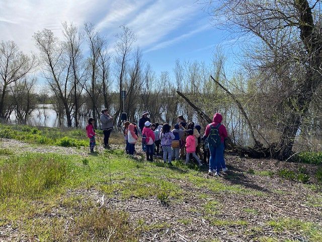
Have you ever seen a 1st grader with a pair of binoculars? When 2 of Woodland Prairie Elementary’s 1st grade classrooms came to join us at the Woodland Regional Park Preserve on March 24th, they were provided with a pair of binoculars to use during their adventure and the reaction was phenomenal. Students were given instructions on how to handle their binoculars and adjust them so they could see clearly. They were then given some time for free exploration, using binoculars to view the wildlife around the preserve before setting off to discover all about ecosystems.


Students were so excited to see anything and everything possible and the critters that inhabit the preserve did not disappoint! Spring time is a time of renewal and birth, so many birds at the preserve are preparing nests and laying eggs. A mating pair of Canada geese have formed a nest near one of the islands in the pond, which students were able to spot despite the distance and without getting wet- thanks to their handy binoculars! We stopped for a moment along the trail and observed the geese swimming in the pond, along with several other birds including a gorgeous Anna’s Hummingbird that likes to inhabit one of the trees on the pond’s perimeter.


As our group traveled around the bend in the trail, we came upon the Red-Tailed Hawk’s large nest. Normally our resident Red-Tailed Hawk, annoyed when there is human company in her preserve, will take flight to a tree some distance away, waiting for us to leave. But not this time! This beautiful bird circled her nest and us, squawking loudly. We didn’t stay long, careful not to upset her, but we did get to engage in a conversation about why she might be so protective all the sudden.


“Does she have babies up there?” one little girl asks.


“Well, that’s a great idea,” I respond. “But do you hear tiny chirps like little baby birds?”


We all listen, observing quietly. No chirps, just her protective cries. “She has eggs!” several students shout at once. And yes, we all conclude, based on our observations, she might have eggs in that nest.


Just past the hawk’s nest is where we make our first official stop as part of our education trail. Our objective is to discover what an ecosystem is, so we set out to observe several different habitats in the preserve. The first habitat is a living tree. Students use their binoculars to make observations about everything they notice about the habitat. Who lives there? Is the top of the tree inhabited by different critters than the bottom? Are there plants as well as animals? We record our observations in a class book and talk about the definition of a habitat. Then we talk about all those living creatures that inhabit the habitat and discover that they form a community.

Next, we move to a tree that died some time ago. Is the dead tree a habitat? Will we find a community of living things here, just as we found at the living tree? Carefully, students lift up decomposing logs and shriek with delight when they discover a whole host of creepy, crawly things including large beetles and sowbugs, ants, and even a centipede! It appears that the dead tree is a habitat, home to a large community of small, living creatures. We record more notes and finally discuss the question we’ve really been after- what is an ecosystem? After some questions and discussion, we conclude that an ecosystem is a habitat with a community, all working together. The first graders, delighted with their work but now very aware that their stomachs are grumbling, head back to the Kiosk area to join the other class for lunch.


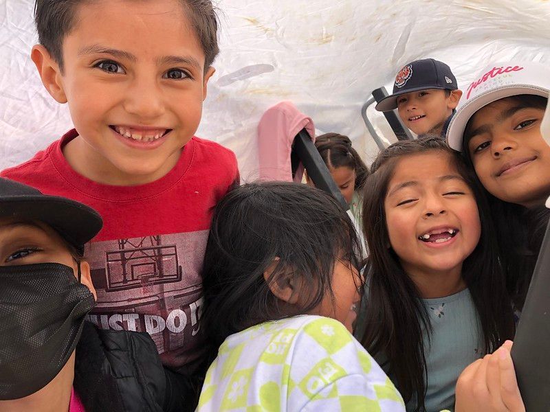
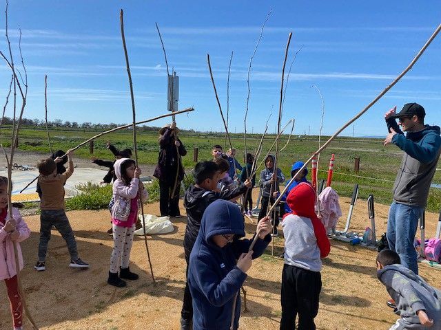
After lunch, the 2 classes switch groups, and each gets to engage in the other adventure. The second adventure scheduled for this day is the Sun Trail. During the Sun Trail, students make observations and run simple experiments to discover the effects of the sun on the living parts of the preserve. They observe what it feels like to stand in the sun and the shade and how water, soil, and rocks are affected when they are left to sit in the sun for a long time. Once students conclude that sometimes it can get too hot, it’s time to make a shade shelter! Students use poles and sheets to create shade shelters (forts) that will protect them from the heat of the sun.

During both trails, observations and discussions were recorded in class books that teachers took back to the classroom to add to their class library. Students will be able to look through and read these books over and over again and remember their time at the preserve.


As students were preparing to leave, they seemed delighted by the day and all they had seen and done. A pair of binoculars and some showy critters who don’t mind a group of 40+ 6-year-olds was more powerful than any video game I’ve come across. I took a minute to chat with one of the teachers who shared with me how grateful he was for this experience. It was the first time they’d been able to plan a field trip since schools had shut down for Covid. I thought about that for a bit and then realized what that meant… as first graders, this was probably their first field trip experience ever. I know these students walked away with a powerful science lesson, but more than that, they walked away with a powerful experience in our beautiful urban preserve.

RECENT ARTICLES

By Nate Lillge August 6, 2025
Bill Grabert is stepping down from his position as treasurer on Tuleyome’s volunteer Board of Directors – we thank him for his many years of service! Bill first joined Tuleyome as a staff member in 2016. His nature-based teaching influenced many youth over the years with school field trips throughout the Berryessa Snow Mountain National Monument region, from Redbud Trail to Conaway Ranch. As part of Tuleyome’s team of instructors for the California Certified Naturalist program, Bill inspired adults to care for the region. His love of the area began as soon as he graduated from college and began working as a geologist in Lake County. Bill has devoted his diverse knowledge and skillset to care for, steward, and enjoy California’s northern Inner Coast Range Mountains for many years. He will be missed on the Board but we look forward to seeing him on the trails! -Nate Lillge (Adventures and Engagement Director)  and Lyndsay Dawkins (Volunteer Tuleyome Board President)
By Bryan Pride August 6, 2025
Fifty-eight and a half million acres of America's wildest forests have been protected for nearly 25 years by the Roadless Rule, a conservation cornerstone that could soon disappear. Established in 2001, the Roadless Area Conservation Rule (RACR) , more commonly known as the Roadless Rule, designated "Inventoried Roadless Areas" (IRAs) across our nation's forests, prohibiting new roads from being built. Now, USDA Secretary Rollins wants to rescind it . From Alaska to California, the losses from this rollback would be massive. In Alaska, 92% of the Tongass National Forest could lose protection, threatening one of the world's most pristine ecosystems and the indigenous communities who call it home. California would lose protections across 4.4 million acres spanning 21 national forests , which has the potential to impact treasured places like Inyo, Shasta-Trinity, and the Berryessa Snow Mountain National Monument. Rule Born from Necessity, Not Ideology The Roadless Rule traces back to 1998, when U.S. Forest Service Chief Mike Dombeck saw the agency's vast road system as a major environmental and fiscal problem . To put this in perspective: the Forest Service maintains eight times more miles of road than the Interstate Highway System. The agency had too many roads to properly maintain for safety and environmental purposes, with poorly maintained roads contributing to erosion and other harms across national forests. The road maintenance backlog had ballooned to $8.4 billion while the agency received only 20% of the funding needed to maintain roads to environmental and safety standards. Dombeck proposed a moratorium on road construction in undeveloped forest areas across most of the National Forest System. The agency adopted an 18-month moratorium in February 1999 pending completion of an overall road management plan. Later that year, the agency undertook a rule making process to provide long-term administrative protection for roadless areas. The Forest Service conducted an extensive public involvement process that produced 1.7 million comments , with the majority favoring a strong national policy protecting roadless areas. The resulting Roadless Rule was not and is still not a blanket ban: it makes exceptions to allow access to non-federal land inholdings and pre-existing mineral leases, and allows logging to reduce fire risk, improve habitat or aid in the recovery of endangered species. What began as a fiscally prudent solution to an unwieldy road network became a cornerstone of forest conservation, one that Americans overwhelmingly supported then and continue to support today. The Administration's Claims vs. Reality According to USDA Secretary Rollins , the rule is “overly restrictive”, hinders fire prevention and responsible timber production, therefore the Rule poses “real harm to millions of acres of our national forests.” Rollins linked rescinding the Rule with Presidential Executive Order 14192, "Unleashing Prosperity Through Deregulation .” The reality is different. Rollins' claim ignores what's actually at stake. Roadless areas are essential ecosystems that provide clean air and water while keeping wilderness intact. They also serve as critical refuges for wildlife; 57% of America's most vulnerable species depend on roadless areas for habitat. For the 156 million Americans who visit national forests annually, these areas offer irreplaceable backcountry recreation experiences. Most strikingly, the administration's fire prevention argument is backwards. Scientific research reveals that 88% of wildfires are human-caused , and 95% of these fires start within half a mile of a road. Areas closest to roads experience 53% more fires than would occur by random chance. Less than 3% of wildfires start in wilderness areas more than a mile from roads. This research indicates that more roads through our forests are more likely to increase fires and would outweigh the effects of improving fire containment. While the administration claims roads improve fire response, fire management teams consistently identify inadequate resources and personnel shortages, not roads , as the primary barriers to effective wildfire management . Rather than building roads that increase fire risk, fire management experts advocate for investing in cultural and prescribed burns, fire mitigation and forest restoration, proven approaches that are underfunded but key to preventing future fires and reducing fire magnitude. What's Next? Rescinding the Roadless Rule will require a public comment period that has yet to be announced. This is when we can all share our views. Tuleyome will be following this issue closely and will be commenting. For more information on the Roadless Rule and how to participate in the public comment process or other advocacy opportunities, contact B ryan Pr ide .
By Kristie Ehrhardt August 6, 2025
The short answer is honestly, pretty much anywhere! Because the 344,476 acre Berryessa Snow Mountain National Monument (the Monument) is located in the rural areas of Colusa, Glenn, Lake, Mendocino, Napa, Solano and Yolo counties you will have a great view of the dark night sky, free from urban light pollution from virtually anywhere within its boundaries! The Monument is an easy drive from not only the metropolitan Sacramento area but also from the San Francisco Bay Area as well as the North Bay communities making it an easy day trip. If you’re here especially for the Perseid meteor shower though it might be a very long day since best viewing happens between the hours of midnight and early morning. If you’re adventurous and up for an all-nighter, be certain to pack plenty of water and snacks and be sure to pull over only where it is safe and you’re not blocking a road, especially when it’s dark. Also always keep safety in mind and look out for wildlife as the Monument is home to black bears, mountain lions, coyotes, tule elk and bobcats that may be traveling through the area as well. If you’d like to stay a night (or several), there are multiple developed campgrounds to choose from inside the Monument boundaries. If you’re up camping, check out The Blue Oaks Campground, Indian Valley Campground, Hunting Creek Campground, Deer Valley Campground, Lower Nye Campground, West Crocket Campground or Kowalski Camping area just to name a few of the sites available for overnight stays. Before you go though, please do check with the United States Forest Service or the Bureau of Land Management websites for details on the particular camping area you’re interested in as well as current conditions, requirements and fire restrictions. The Monument also offers primitive camping in the three wilderness areas located within the Monument boundaries. Cache Creek Wilderness, Cedar Roughs Wilderness and Snow Mountain Wilderness present nearly unlimited opportunities for dispersed camping or backcountry camping (areas located outside of designated campgrounds). Although camping is allowed and encouraged, these areas have no amenities such as tables, toilets, available water or waste removal and require you to pack out all trash and waste. There are no motorized vehicles allowed within Wilderness areas and they provide places for deep solitude with nature. Camping in Wilderness areas or other dispersed camping areas require visitors to understand and follow the Leave No Trace principles of outdoor recreating as well as planning ahead and knowing the area and what to pack. That said, other than the trees potentially blocking some of the night sky, you’re sure to avoid urban light pollution and have an unobstructed view of the night sky from practically anywhere within the Monument! -Kristie Ehrhardt ( kehrhardt@tuleyome.org ) Tuleyome Land Conservation Program Manager