Science Corner - Cedar Waxwings, a Sociable and Stylish Wintertime Visitor

Kristie Ehrhardt • January 9, 2025

Years ago I was sitting in my Volkswagen Jetta (rest in peace, fun little car) in a grocery store parking lot in Sacramento. I was parked under a hackberry tree that was brimming with oodles of petite, buffy-yellow birds with pointy little crowns. The birds were gorging themselves on the berries from the tree and depositing digested bits all over my car but I didn’t care, I was enthralled by these new little friends.


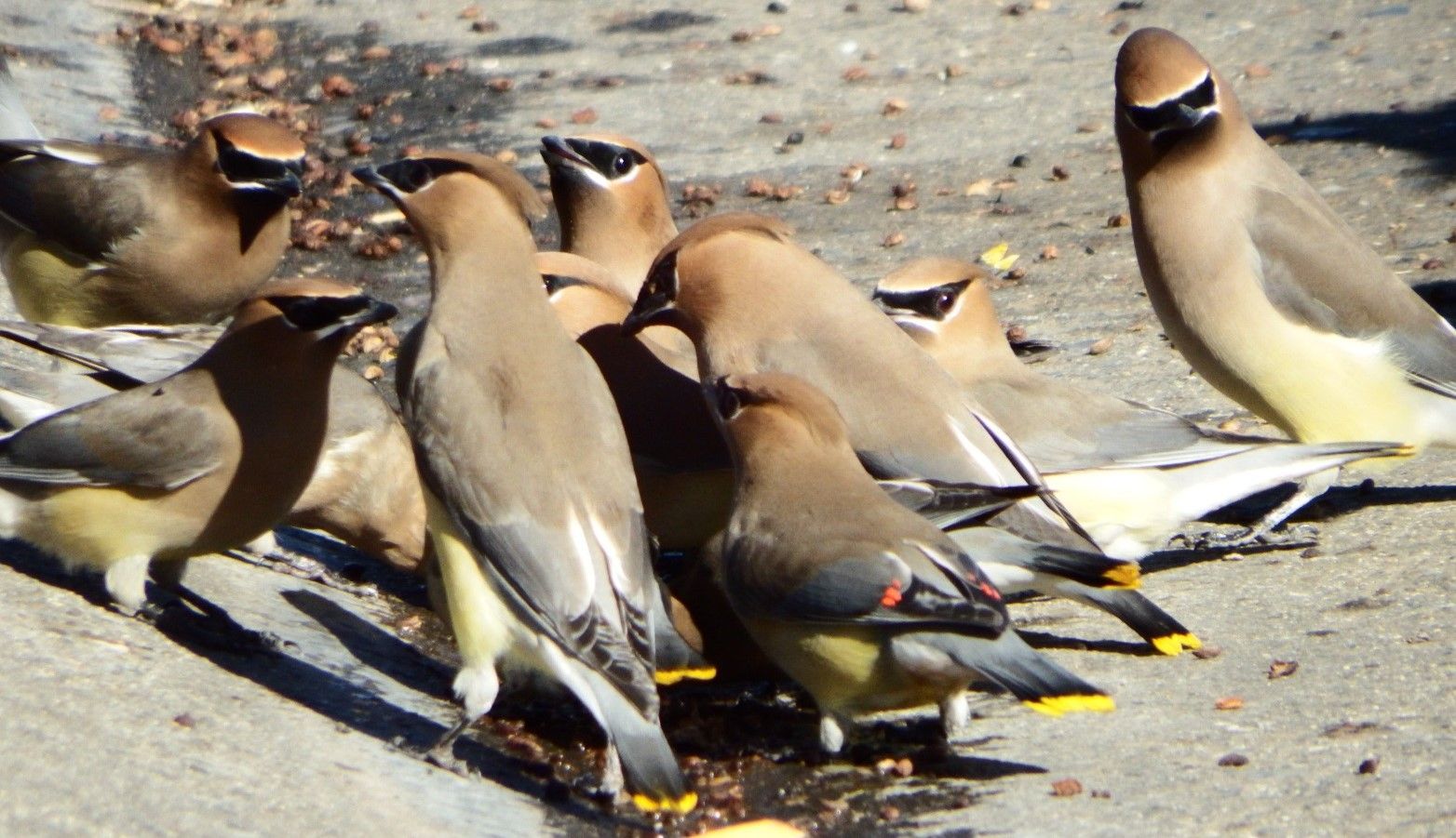
This was my first encounter with Cedar Waxwings (Bombycilla cedrorum). I don’t know why, or how, I hadn’t noticed them before with their stunning black face mask, satiny buffy-yellow body feathers, sunny lemon-tipped tail and bright red waxy droplets on their wings - which is where their common name comes from.


Their Latin name, Bombycilla cedrorum literally translates to “silk of the cedars” referring to their silky, chiffon-looking plumage. They are native to North and Central America and breed in the woodlands of southern Canada. And migrate to winter in the southern United States, Central America and sometimes as far as northwest South America. Although they specialize in eating fruit, they also consume insects and flowers for a short time during nesting season. Cedar Waxwings are a medium size bird with a wing span of about six and a half inches and they weigh around an ounce - about the weight of a pencil. What appears to be wax droplets at the end of their secondary feathers are actually an accumulation of astaxanthin, a carotenoid that gives some fruit its red color. The red pigment is surrounded by a transparent cuticle which allows the color to show though. The size and number of these “droplets” are directly correlated with the age of the bird and it is believed that they convey social status among the flock. Cedar Waxwings are congenial and large groups of them are found among the edges of forests and woodlands but are also common in urban areas with easy access to fruiting shrubs and trees within their range. They are attracted to the sound of running water such as creeks, fountains and birdbaths. They are nomadic and will move in huge groups to find new berry supplies.


Breeding season occurs while the birds are in Canada and begins in late spring and lasts through the end of summer. The male will hop in front of a female and if she is interested, she returns the gesture. A mated pair will sit together and pass an object such as a flower petal or an insect back and forth. Both Cedar Waxwing males and females have the same plumage (monomorphism) which is true with about half of all bird species, unlike waterfowl where males and females look different from each other. Both the male and female work on nest construction and will sometimes steal material from other species’ nests.


The current population is estimated to be about 57 million birds. They begin to show up in the Sacramento area in September and stick around until about May depending on food availability. To invite these cordial little birds to your yard for their winter vacation, plant fruiting trees and shrubs that produce berries and provide a clean water source. Enjoy watching them!


Fun facts about Cedar Waxwings:

  • Cedar Waxwings have specialized digestion and can survive almost solely on fruit while other species cannot. The parasitic Brown-headed Cowbird lays eggs in the nests of other bird species for the parents to raise. The eggs that are laid in Cedar Waxwing nests often do not survive due to the high percentage of fruit.
  • If Cedar Waxwings eat over-ripe fruit that has begun to ferment, they can become intoxicated.
  • Some Cedar Waxwings in the northeastern states have an orange tipped tail due to the red pigments in a certain berry. If the bird eats a bunch of these berries while the feather is growing, the tip will be orange rather than yellow.
  • Sometimes, if berries are difficult to reach, Cedar Waxwings will line up and pass berries beak to beak down the line until one of them swallows it.


-Kristie Ehrhardt (kehrhardt@tuleyome.org)

Tuleyome Land Conservation Program Manager

RECENT ARTICLES

By Nate Lillge August 6, 2025
Bill Grabert is stepping down from his position as treasurer on Tuleyome’s volunteer Board of Directors – we thank him for his many years of service! Bill first joined Tuleyome as a staff member in 2016. His nature-based teaching influenced many youth over the years with school field trips throughout the Berryessa Snow Mountain National Monument region, from Redbud Trail to Conaway Ranch. As part of Tuleyome’s team of instructors for the California Certified Naturalist program, Bill inspired adults to care for the region. His love of the area began as soon as he graduated from college and began working as a geologist in Lake County. Bill has devoted his diverse knowledge and skillset to care for, steward, and enjoy California’s northern Inner Coast Range Mountains for many years. He will be missed on the Board but we look forward to seeing him on the trails! -Nate Lillge (Adventures and Engagement Director)  and Lyndsay Dawkins (Volunteer Tuleyome Board President)
By Bryan Pride August 6, 2025
Fifty-eight and a half million acres of America's wildest forests have been protected for nearly 25 years by the Roadless Rule, a conservation cornerstone that could soon disappear. Established in 2001, the Roadless Area Conservation Rule (RACR) , more commonly known as the Roadless Rule, designated "Inventoried Roadless Areas" (IRAs) across our nation's forests, prohibiting new roads from being built. Now, USDA Secretary Rollins wants to rescind it . From Alaska to California, the losses from this rollback would be massive. In Alaska, 92% of the Tongass National Forest could lose protection, threatening one of the world's most pristine ecosystems and the indigenous communities who call it home. California would lose protections across 4.4 million acres spanning 21 national forests , which has the potential to impact treasured places like Inyo, Shasta-Trinity, and the Berryessa Snow Mountain National Monument. Rule Born from Necessity, Not Ideology The Roadless Rule traces back to 1998, when U.S. Forest Service Chief Mike Dombeck saw the agency's vast road system as a major environmental and fiscal problem . To put this in perspective: the Forest Service maintains eight times more miles of road than the Interstate Highway System. The agency had too many roads to properly maintain for safety and environmental purposes, with poorly maintained roads contributing to erosion and other harms across national forests. The road maintenance backlog had ballooned to $8.4 billion while the agency received only 20% of the funding needed to maintain roads to environmental and safety standards. Dombeck proposed a moratorium on road construction in undeveloped forest areas across most of the National Forest System. The agency adopted an 18-month moratorium in February 1999 pending completion of an overall road management plan. Later that year, the agency undertook a rule making process to provide long-term administrative protection for roadless areas. The Forest Service conducted an extensive public involvement process that produced 1.7 million comments , with the majority favoring a strong national policy protecting roadless areas. The resulting Roadless Rule was not and is still not a blanket ban: it makes exceptions to allow access to non-federal land inholdings and pre-existing mineral leases, and allows logging to reduce fire risk, improve habitat or aid in the recovery of endangered species. What began as a fiscally prudent solution to an unwieldy road network became a cornerstone of forest conservation, one that Americans overwhelmingly supported then and continue to support today. The Administration's Claims vs. Reality According to USDA Secretary Rollins , the rule is “overly restrictive”, hinders fire prevention and responsible timber production, therefore the Rule poses “real harm to millions of acres of our national forests.” Rollins linked rescinding the Rule with Presidential Executive Order 14192, "Unleashing Prosperity Through Deregulation .” The reality is different. Rollins' claim ignores what's actually at stake. Roadless areas are essential ecosystems that provide clean air and water while keeping wilderness intact. They also serve as critical refuges for wildlife; 57% of America's most vulnerable species depend on roadless areas for habitat. For the 156 million Americans who visit national forests annually, these areas offer irreplaceable backcountry recreation experiences. Most strikingly, the administration's fire prevention argument is backwards. Scientific research reveals that 88% of wildfires are human-caused , and 95% of these fires start within half a mile of a road. Areas closest to roads experience 53% more fires than would occur by random chance. Less than 3% of wildfires start in wilderness areas more than a mile from roads. This research indicates that more roads through our forests are more likely to increase fires and would outweigh the effects of improving fire containment. While the administration claims roads improve fire response, fire management teams consistently identify inadequate resources and personnel shortages, not roads , as the primary barriers to effective wildfire management . Rather than building roads that increase fire risk, fire management experts advocate for investing in cultural and prescribed burns, fire mitigation and forest restoration, proven approaches that are underfunded but key to preventing future fires and reducing fire magnitude. What's Next? Rescinding the Roadless Rule will require a public comment period that has yet to be announced. This is when we can all share our views. Tuleyome will be following this issue closely and will be commenting. For more information on the Roadless Rule and how to participate in the public comment process or other advocacy opportunities, contact B ryan Pr ide .
By Kristie Ehrhardt August 6, 2025
The short answer is honestly, pretty much anywhere! Because the 344,476 acre Berryessa Snow Mountain National Monument (the Monument) is located in the rural areas of Colusa, Glenn, Lake, Mendocino, Napa, Solano and Yolo counties you will have a great view of the dark night sky, free from urban light pollution from virtually anywhere within its boundaries! The Monument is an easy drive from not only the metropolitan Sacramento area but also from the San Francisco Bay Area as well as the North Bay communities making it an easy day trip. If you’re here especially for the Perseid meteor shower though it might be a very long day since best viewing happens between the hours of midnight and early morning. If you’re adventurous and up for an all-nighter, be certain to pack plenty of water and snacks and be sure to pull over only where it is safe and you’re not blocking a road, especially when it’s dark. Also always keep safety in mind and look out for wildlife as the Monument is home to black bears, mountain lions, coyotes, tule elk and bobcats that may be traveling through the area as well. If you’d like to stay a night (or several), there are multiple developed campgrounds to choose from inside the Monument boundaries. If you’re up camping, check out The Blue Oaks Campground, Indian Valley Campground, Hunting Creek Campground, Deer Valley Campground, Lower Nye Campground, West Crocket Campground or Kowalski Camping area just to name a few of the sites available for overnight stays. Before you go though, please do check with the United States Forest Service or the Bureau of Land Management websites for details on the particular camping area you’re interested in as well as current conditions, requirements and fire restrictions. The Monument also offers primitive camping in the three wilderness areas located within the Monument boundaries. Cache Creek Wilderness, Cedar Roughs Wilderness and Snow Mountain Wilderness present nearly unlimited opportunities for dispersed camping or backcountry camping (areas located outside of designated campgrounds). Although camping is allowed and encouraged, these areas have no amenities such as tables, toilets, available water or waste removal and require you to pack out all trash and waste. There are no motorized vehicles allowed within Wilderness areas and they provide places for deep solitude with nature. Camping in Wilderness areas or other dispersed camping areas require visitors to understand and follow the Leave No Trace principles of outdoor recreating as well as planning ahead and knowing the area and what to pack. That said, other than the trees potentially blocking some of the night sky, you’re sure to avoid urban light pollution and have an unobstructed view of the night sky from practically anywhere within the Monument! -Kristie Ehrhardt ( kehrhardt@tuleyome.org ) Tuleyome Land Conservation Program Manager