Science Corner - Wetlands!

Kristie Ehrhardt • September 4, 2024

You may already know that wetlands are one of the most productive (and most endangered) ecosystems on the entire globe and are often compared to coral reefs and rainforests because of the habitat they provide for an extensive variety of plants and wildlife. But, did you know that wetlands are also responsible for filtering our drinking water? Just one acre of wetland, roughly the size of a football field, can filter over seven million gallons of water per year (Ducks Unlimited, 2024). To help you visualize, a swimming pool that would hold one million gallons would be nearly 270 feet long, 50 feet wide and 10 feet deep. Now make that pool seven times bigger plus a little extra!


The City of Woodland gets drinking water from both treated surface water and from groundwater wells. Groundwater is stored underground (bet you didn’t see that coming, eh?) in aquifers. Aquifers are natural basins found a few feet to several thousands of feet below the surface. 40% of the land area of California is occupied by aquifers and there are two types, unconfined and confined. Unconfined aquifers are essentially the space between porous material like gravel, sand and silt and can be replenished. Confined aquifers are isolated below layers of rock and cannot be replenished in measurable amounts. 


How are unconfined aquifers replenished you ask? Great question! During the rainy season aquifers naturally get replenished when rainwater collects in rivers, ponds, creeks, lakes, marshes, stormwater retention basins and other wetlands. This water then percolates down through the ground until it reaches the aquifer. This is called direct recharge. Agricultural canals and irrigation also contribute to direct recharge. River and especially agricultural water is not safe to drink so wetlands act as nature’s filter to clean it before it reaches the aquifer.

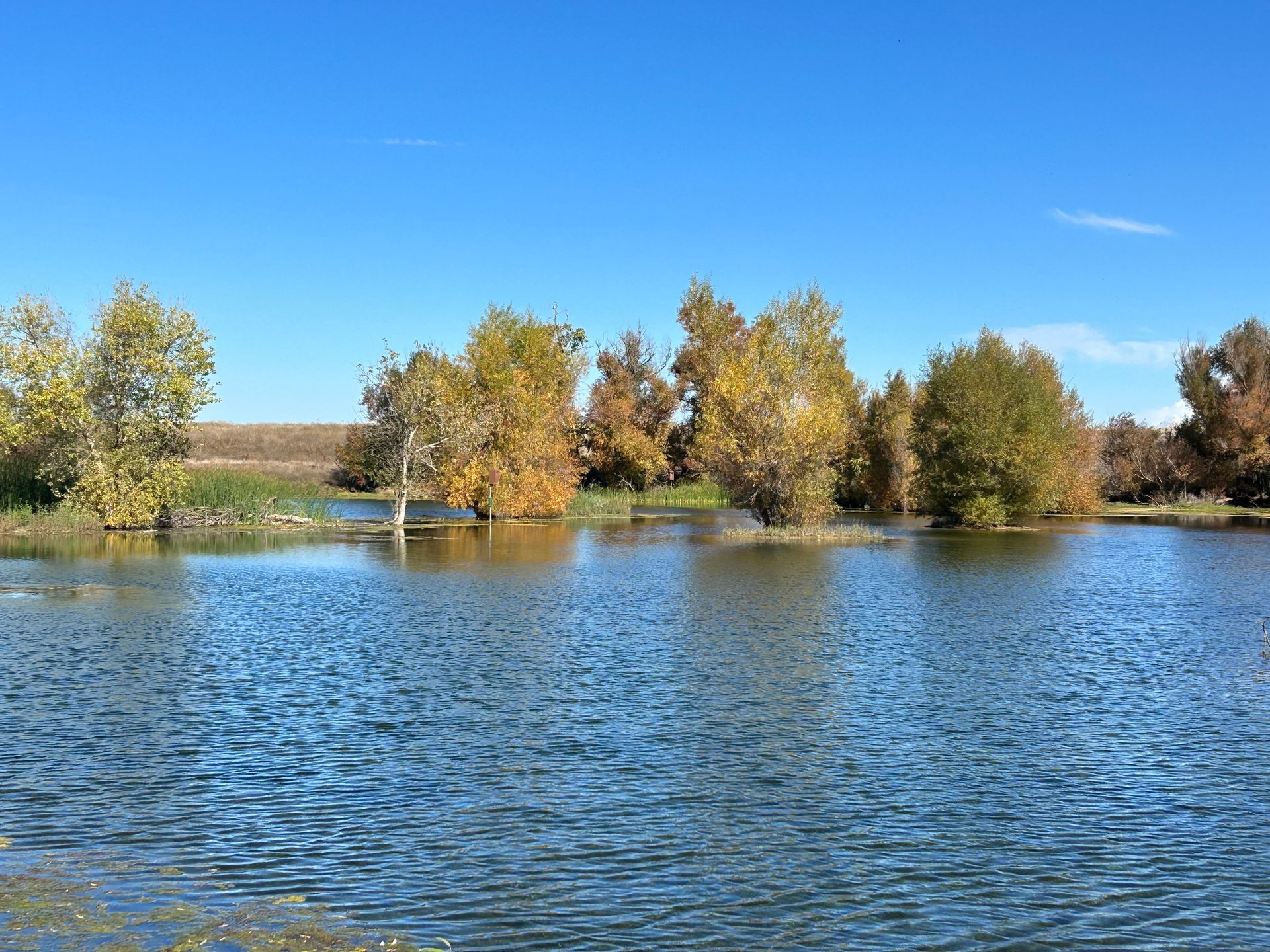
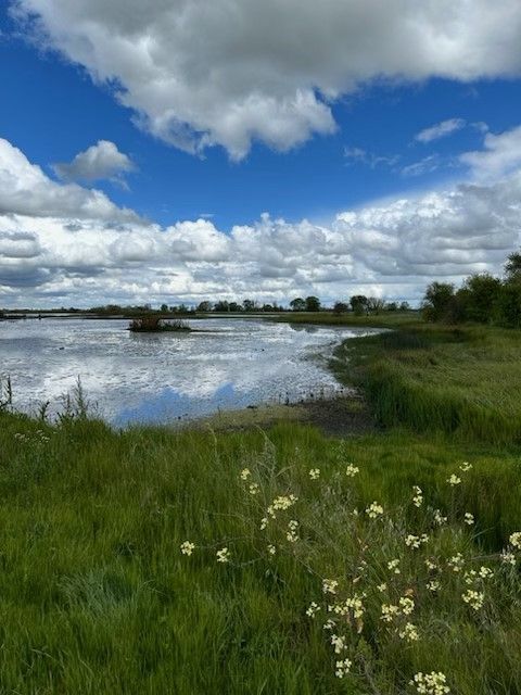
Wetlands such as those found at the Woodland Regional Park Preserve (WRPP) and many other areas of California help clean our drinking water. Wetlands are depressions in the surface that collect water either seasonally or permanently. Because of the duration of ponded water only plants that can tolerate these saturated conditions live there. The decomposition of these plants along with the presence of ponded water create certain soil characteristics that help define a wetland. When rainfall reaches the ground, it can either move over the surface or seep into the soil. Heavy rain falling on impermeable surfaces like streets, sidewalks and buildings cause the water to rapidly flow and runoff to lower elevations. As quickly flowing water enters a wetland, the vegetation and topography slow it down. This allows the heavy sediments picked up by fast moving water to drop out. Slowing the water down also reduces the risk of erosion and structural damage downstream. As the water flow slows, the roots of the wetland's plants are able to absorb excess or toxic nutrients like nitrogen and phosphorus. Wetlands act as a sponge and are able to store the excess water and slowly release it into the environment. Containing the water not only reduces downstream erosion damage caused by rapidly flowing water, it also allows the water to slowly transfer through the soil and eventually reach the aquifer. Collecting and holding on to the water helps the wetland act like a filter that aids in trapping nutrients, pollutants and sediments before they reach and recharge our aquifers.


Wetlands all over the world provide habitat for threatened and endangered plants and animals as well as migrating birds. The wetlands at WRPP are a small part of the Pacific Flyway which provides winter rest and refueling stops for an estimated one billion migrating birds. Plants found only in wetlands not only help feed these billion birds and filter out toxins, they also absorb greenhouse gasses which helps create cleaner air in addition to cleaner water! 


-Kristie Ehrhardt (kehrhardt@tuleyome.org)

Tuleyome Land Conservation Program Manager

RECENT ARTICLES

By Nate Lillge August 6, 2025
Bill Grabert is stepping down from his position as treasurer on Tuleyome’s volunteer Board of Directors – we thank him for his many years of service! Bill first joined Tuleyome as a staff member in 2016. His nature-based teaching influenced many youth over the years with school field trips throughout the Berryessa Snow Mountain National Monument region, from Redbud Trail to Conaway Ranch. As part of Tuleyome’s team of instructors for the California Certified Naturalist program, Bill inspired adults to care for the region. His love of the area began as soon as he graduated from college and began working as a geologist in Lake County. Bill has devoted his diverse knowledge and skillset to care for, steward, and enjoy California’s northern Inner Coast Range Mountains for many years. He will be missed on the Board but we look forward to seeing him on the trails! -Nate Lillge (Adventures and Engagement Director)  and Lyndsay Dawkins (Volunteer Tuleyome Board President)
By Bryan Pride August 6, 2025
Fifty-eight and a half million acres of America's wildest forests have been protected for nearly 25 years by the Roadless Rule, a conservation cornerstone that could soon disappear. Established in 2001, the Roadless Area Conservation Rule (RACR) , more commonly known as the Roadless Rule, designated "Inventoried Roadless Areas" (IRAs) across our nation's forests, prohibiting new roads from being built. Now, USDA Secretary Rollins wants to rescind it . From Alaska to California, the losses from this rollback would be massive. In Alaska, 92% of the Tongass National Forest could lose protection, threatening one of the world's most pristine ecosystems and the indigenous communities who call it home. California would lose protections across 4.4 million acres spanning 21 national forests , which has the potential to impact treasured places like Inyo, Shasta-Trinity, and the Berryessa Snow Mountain National Monument. Rule Born from Necessity, Not Ideology The Roadless Rule traces back to 1998, when U.S. Forest Service Chief Mike Dombeck saw the agency's vast road system as a major environmental and fiscal problem . To put this in perspective: the Forest Service maintains eight times more miles of road than the Interstate Highway System. The agency had too many roads to properly maintain for safety and environmental purposes, with poorly maintained roads contributing to erosion and other harms across national forests. The road maintenance backlog had ballooned to $8.4 billion while the agency received only 20% of the funding needed to maintain roads to environmental and safety standards. Dombeck proposed a moratorium on road construction in undeveloped forest areas across most of the National Forest System. The agency adopted an 18-month moratorium in February 1999 pending completion of an overall road management plan. Later that year, the agency undertook a rule making process to provide long-term administrative protection for roadless areas. The Forest Service conducted an extensive public involvement process that produced 1.7 million comments , with the majority favoring a strong national policy protecting roadless areas. The resulting Roadless Rule was not and is still not a blanket ban: it makes exceptions to allow access to non-federal land inholdings and pre-existing mineral leases, and allows logging to reduce fire risk, improve habitat or aid in the recovery of endangered species. What began as a fiscally prudent solution to an unwieldy road network became a cornerstone of forest conservation, one that Americans overwhelmingly supported then and continue to support today. The Administration's Claims vs. Reality According to USDA Secretary Rollins , the rule is “overly restrictive”, hinders fire prevention and responsible timber production, therefore the Rule poses “real harm to millions of acres of our national forests.” Rollins linked rescinding the Rule with Presidential Executive Order 14192, "Unleashing Prosperity Through Deregulation .” The reality is different. Rollins' claim ignores what's actually at stake. Roadless areas are essential ecosystems that provide clean air and water while keeping wilderness intact. They also serve as critical refuges for wildlife; 57% of America's most vulnerable species depend on roadless areas for habitat. For the 156 million Americans who visit national forests annually, these areas offer irreplaceable backcountry recreation experiences. Most strikingly, the administration's fire prevention argument is backwards. Scientific research reveals that 88% of wildfires are human-caused , and 95% of these fires start within half a mile of a road. Areas closest to roads experience 53% more fires than would occur by random chance. Less than 3% of wildfires start in wilderness areas more than a mile from roads. This research indicates that more roads through our forests are more likely to increase fires and would outweigh the effects of improving fire containment. While the administration claims roads improve fire response, fire management teams consistently identify inadequate resources and personnel shortages, not roads , as the primary barriers to effective wildfire management . Rather than building roads that increase fire risk, fire management experts advocate for investing in cultural and prescribed burns, fire mitigation and forest restoration, proven approaches that are underfunded but key to preventing future fires and reducing fire magnitude. What's Next? Rescinding the Roadless Rule will require a public comment period that has yet to be announced. This is when we can all share our views. Tuleyome will be following this issue closely and will be commenting. For more information on the Roadless Rule and how to participate in the public comment process or other advocacy opportunities, contact B ryan Pr ide .
By Kristie Ehrhardt August 6, 2025
The short answer is honestly, pretty much anywhere! Because the 344,476 acre Berryessa Snow Mountain National Monument (the Monument) is located in the rural areas of Colusa, Glenn, Lake, Mendocino, Napa, Solano and Yolo counties you will have a great view of the dark night sky, free from urban light pollution from virtually anywhere within its boundaries! The Monument is an easy drive from not only the metropolitan Sacramento area but also from the San Francisco Bay Area as well as the North Bay communities making it an easy day trip. If you’re here especially for the Perseid meteor shower though it might be a very long day since best viewing happens between the hours of midnight and early morning. If you’re adventurous and up for an all-nighter, be certain to pack plenty of water and snacks and be sure to pull over only where it is safe and you’re not blocking a road, especially when it’s dark. Also always keep safety in mind and look out for wildlife as the Monument is home to black bears, mountain lions, coyotes, tule elk and bobcats that may be traveling through the area as well. If you’d like to stay a night (or several), there are multiple developed campgrounds to choose from inside the Monument boundaries. If you’re up camping, check out The Blue Oaks Campground, Indian Valley Campground, Hunting Creek Campground, Deer Valley Campground, Lower Nye Campground, West Crocket Campground or Kowalski Camping area just to name a few of the sites available for overnight stays. Before you go though, please do check with the United States Forest Service or the Bureau of Land Management websites for details on the particular camping area you’re interested in as well as current conditions, requirements and fire restrictions. The Monument also offers primitive camping in the three wilderness areas located within the Monument boundaries. Cache Creek Wilderness, Cedar Roughs Wilderness and Snow Mountain Wilderness present nearly unlimited opportunities for dispersed camping or backcountry camping (areas located outside of designated campgrounds). Although camping is allowed and encouraged, these areas have no amenities such as tables, toilets, available water or waste removal and require you to pack out all trash and waste. There are no motorized vehicles allowed within Wilderness areas and they provide places for deep solitude with nature. Camping in Wilderness areas or other dispersed camping areas require visitors to understand and follow the Leave No Trace principles of outdoor recreating as well as planning ahead and knowing the area and what to pack. That said, other than the trees potentially blocking some of the night sky, you’re sure to avoid urban light pollution and have an unobstructed view of the night sky from practically anywhere within the Monument! -Kristie Ehrhardt ( kehrhardt@tuleyome.org ) Tuleyome Land Conservation Program Manager