Science Corner: Manzanita

Geoffrey Benn • February 12, 2024

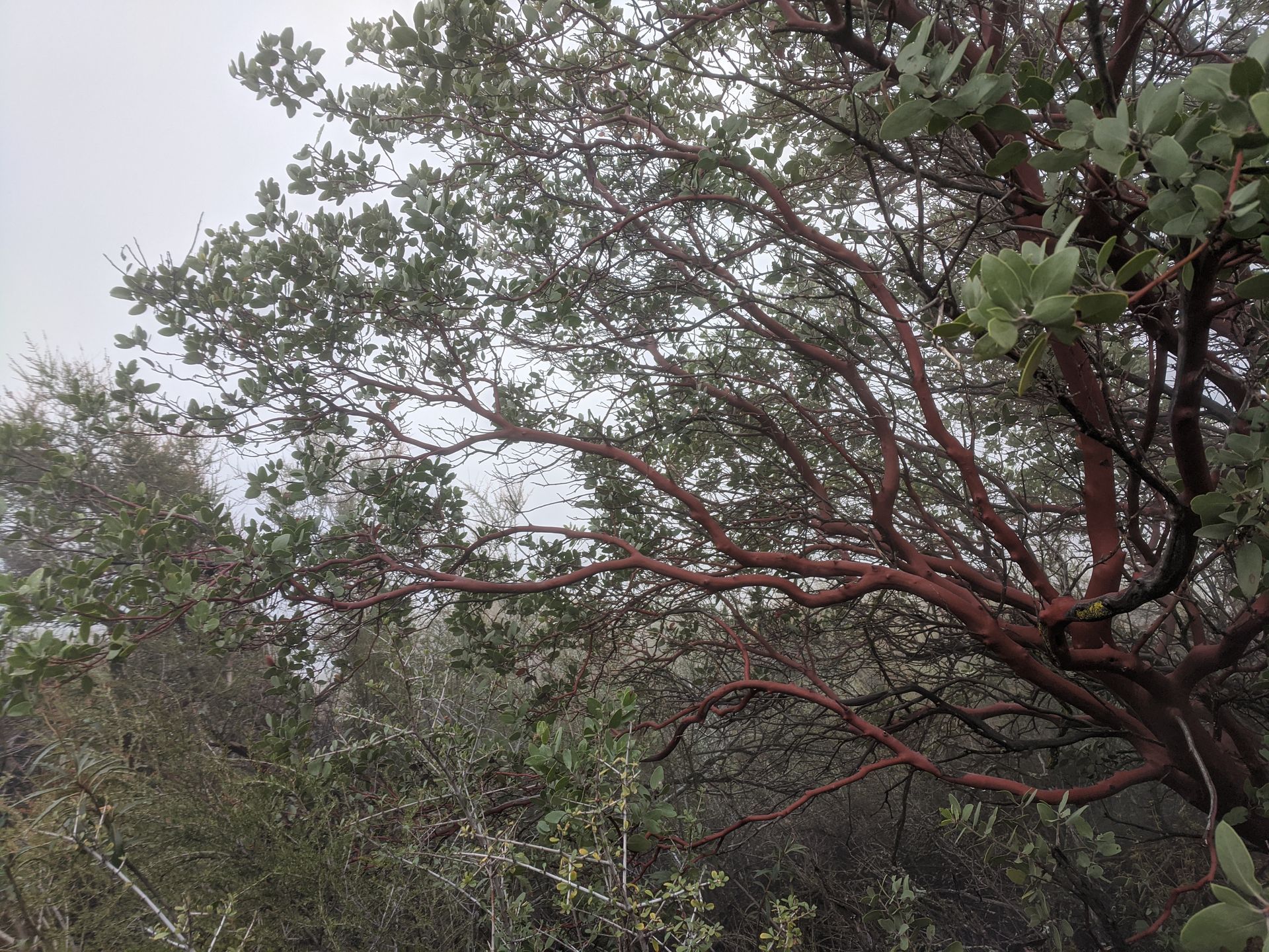
A common manzanita reaches out into the fog on Fiske Peak by Geoff Benn

Shortly after moving from the Midwest to California in 2009, I encountered the strange and wonderful manzanita for the first time, while on a hike in Napa. It looked like something out of a Star Trek set, with smooth bright red bark that seemed as if it had been poured onto the sinewy branches from a hot candle. After completing the hike, I learned that the weird-looking shrubs were manzanitas and have been fascinated ever since.

Manzanitas, whose common name comes from Spanish for “little apple”, are small trees and shrubs in the genus Arctostaphylos. California is a global diversity hotspot for the genus, with 95 named species and subspecies. The bulk of that diversity is found in the coastal counties of California, particularly in the central coast region, where it is thought that ancestral populations of manzanitas became isolated on patches of poor rocky soil and eventually developed into separate species or subspecies. In Yolo County, the species most frequently encountered is the common manzanita ( Arctostaphylos manzanita ssp manzanita ).

Like many California plant species, manzanitas have evolved to cope with wildfire. About 1/3 rd of the species can resprout from burls at the bases of their stems following fires, but the majority are obligate seeders, meaning that the plants will generally not survive fires and instead depend on seeds lying dormant in the soil from previous years to carry on the next generation. These seeds, often buried by rodents, will remain in their dormant state until they sense chemicals produced by wood burning in a wildfire. Once this occurs, the seeds will germinate and have a chance to grow with greatly reduced competition.

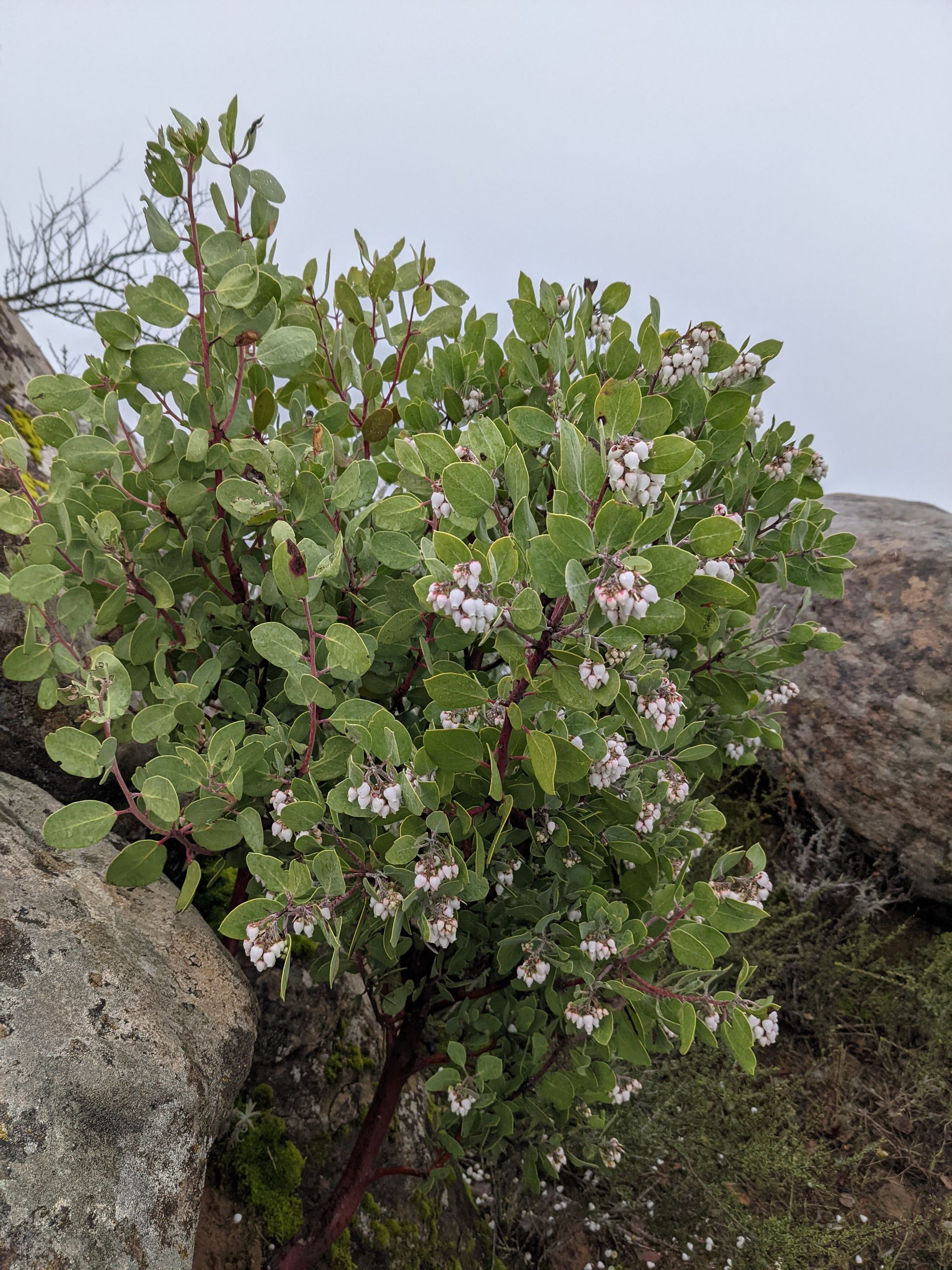
Common Manzanita blooming along the Fiske Peak trail in early February by Geoff Benn

Manzanitas are one of the first plants to flower in the inner coast range, typically producing their characteristic diminutive bell-shaped blooms in January and February. We saw manzanitas in full flower along the Blue Ridge last weekend during Tuleyome’s Fiske Peak hike. The unusual shape, downward-facing orientation, and very small opening of the flower raises the question of how manzanitas are pollinated. While some studies have indicated a role for small insects, such as thrips, in manzanita pollination, it is thought that most species depend on bumblebees for pollination. This is because bumblebees are able to do buzz pollination, where the insect latches onto the mouth of the flower, then uses its flight muscles to vibrate the flower and release the pollen.

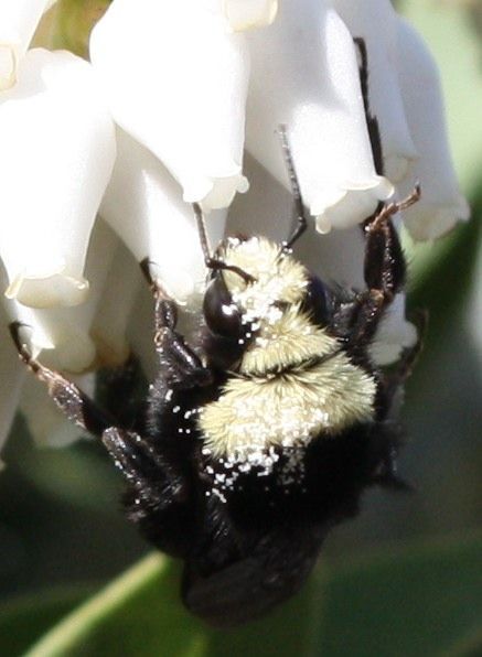
Bumblebee pollinating manzanita flowers by Laura Camp


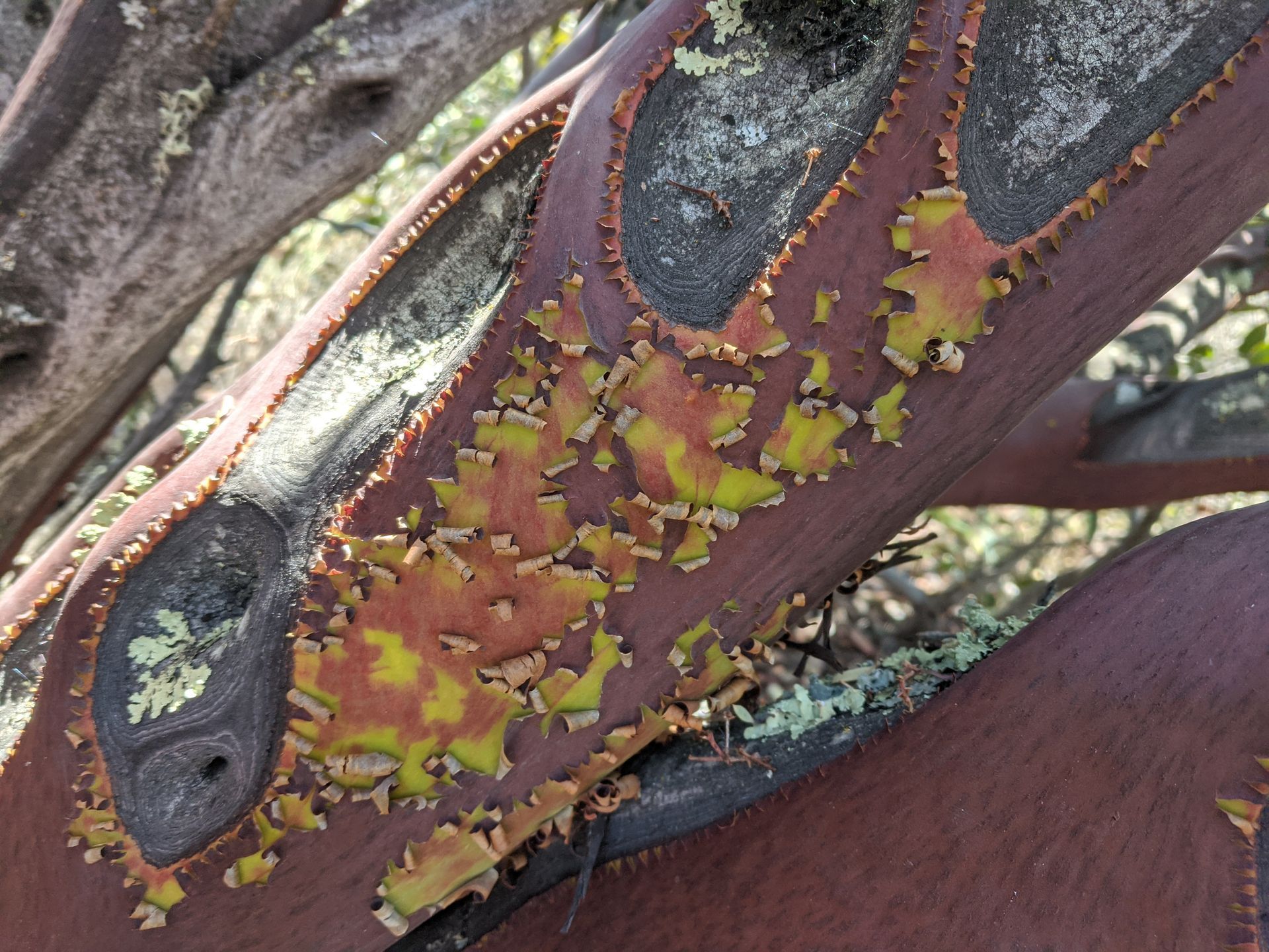
Manzanita with peeling bark and exposed dead wood. Note the green layer beneath the peeling bark by Geoff Benn

While manzanita flowers are quite pretty, the most visually striking aspect of the plant has to be its bright red bark, which is paper-thin, peels off annually, and may even die away completely along parts of a branch. There are several potential benefits of having thin bark, including allowing for stem photosynthesis in tissues just beneath the bark and preventing buildup of fungi and other organisms on the plant. In old manzanitas, it is common to see ribbons of bark interspersed with patches of dead wood – this has not been well-studied, but it could be similar to the phenomenon observed in bristlecone pines, where some branches and the vascular tissue that connects them to the rest of the plant (found just below the bark) die off to conserve resources.

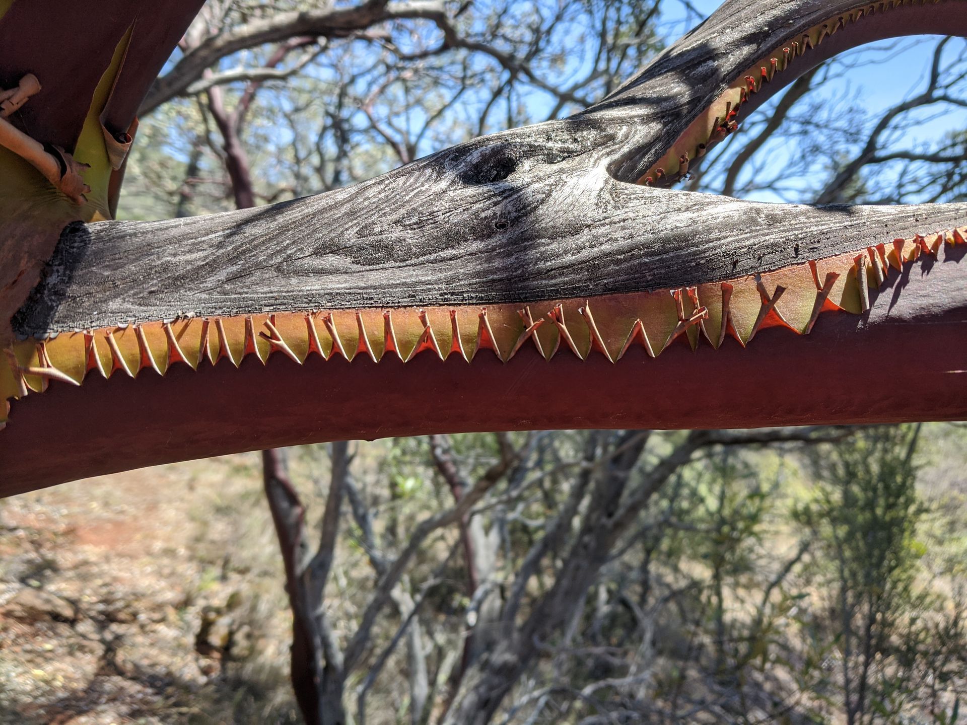
Manzanita with peeling bark and exposed dead wood by Geoff Benn

While perhaps not as widely known as bristlecone pines and redwoods outside of California, I think that the manzanita has earned a place in pantheon of iconic Californian plants. If you’d like to learn more about these fascinating plants, I encourage you to watch this CNPS lecture from Kate Marianchild and check out the excellent Field Guide to Manzanitas .

-Geoff Benn gbenn@tuleyome.org

Tuleyome Education Associate

Looking for more articles like this? Click the hashtag below!

RECENT ARTICLES

By Nate Lillge August 6, 2025
Bill Grabert is stepping down from his position as treasurer on Tuleyome’s volunteer Board of Directors – we thank him for his many years of service! Bill first joined Tuleyome as a staff member in 2016. His nature-based teaching influenced many youth over the years with school field trips throughout the Berryessa Snow Mountain National Monument region, from Redbud Trail to Conaway Ranch. As part of Tuleyome’s team of instructors for the California Certified Naturalist program, Bill inspired adults to care for the region. His love of the area began as soon as he graduated from college and began working as a geologist in Lake County. Bill has devoted his diverse knowledge and skillset to care for, steward, and enjoy California’s northern Inner Coast Range Mountains for many years. He will be missed on the Board but we look forward to seeing him on the trails! -Nate Lillge (Adventures and Engagement Director)  and Lyndsay Dawkins (Volunteer Tuleyome Board President)
By Bryan Pride August 6, 2025
Fifty-eight and a half million acres of America's wildest forests have been protected for nearly 25 years by the Roadless Rule, a conservation cornerstone that could soon disappear. Established in 2001, the Roadless Area Conservation Rule (RACR) , more commonly known as the Roadless Rule, designated "Inventoried Roadless Areas" (IRAs) across our nation's forests, prohibiting new roads from being built. Now, USDA Secretary Rollins wants to rescind it . From Alaska to California, the losses from this rollback would be massive. In Alaska, 92% of the Tongass National Forest could lose protection, threatening one of the world's most pristine ecosystems and the indigenous communities who call it home. California would lose protections across 4.4 million acres spanning 21 national forests , which has the potential to impact treasured places like Inyo, Shasta-Trinity, and the Berryessa Snow Mountain National Monument. Rule Born from Necessity, Not Ideology The Roadless Rule traces back to 1998, when U.S. Forest Service Chief Mike Dombeck saw the agency's vast road system as a major environmental and fiscal problem . To put this in perspective: the Forest Service maintains eight times more miles of road than the Interstate Highway System. The agency had too many roads to properly maintain for safety and environmental purposes, with poorly maintained roads contributing to erosion and other harms across national forests. The road maintenance backlog had ballooned to $8.4 billion while the agency received only 20% of the funding needed to maintain roads to environmental and safety standards. Dombeck proposed a moratorium on road construction in undeveloped forest areas across most of the National Forest System. The agency adopted an 18-month moratorium in February 1999 pending completion of an overall road management plan. Later that year, the agency undertook a rule making process to provide long-term administrative protection for roadless areas. The Forest Service conducted an extensive public involvement process that produced 1.7 million comments , with the majority favoring a strong national policy protecting roadless areas. The resulting Roadless Rule was not and is still not a blanket ban: it makes exceptions to allow access to non-federal land inholdings and pre-existing mineral leases, and allows logging to reduce fire risk, improve habitat or aid in the recovery of endangered species. What began as a fiscally prudent solution to an unwieldy road network became a cornerstone of forest conservation, one that Americans overwhelmingly supported then and continue to support today. The Administration's Claims vs. Reality According to USDA Secretary Rollins , the rule is “overly restrictive”, hinders fire prevention and responsible timber production, therefore the Rule poses “real harm to millions of acres of our national forests.” Rollins linked rescinding the Rule with Presidential Executive Order 14192, "Unleashing Prosperity Through Deregulation .” The reality is different. Rollins' claim ignores what's actually at stake. Roadless areas are essential ecosystems that provide clean air and water while keeping wilderness intact. They also serve as critical refuges for wildlife; 57% of America's most vulnerable species depend on roadless areas for habitat. For the 156 million Americans who visit national forests annually, these areas offer irreplaceable backcountry recreation experiences. Most strikingly, the administration's fire prevention argument is backwards. Scientific research reveals that 88% of wildfires are human-caused , and 95% of these fires start within half a mile of a road. Areas closest to roads experience 53% more fires than would occur by random chance. Less than 3% of wildfires start in wilderness areas more than a mile from roads. This research indicates that more roads through our forests are more likely to increase fires and would outweigh the effects of improving fire containment. While the administration claims roads improve fire response, fire management teams consistently identify inadequate resources and personnel shortages, not roads , as the primary barriers to effective wildfire management . Rather than building roads that increase fire risk, fire management experts advocate for investing in cultural and prescribed burns, fire mitigation and forest restoration, proven approaches that are underfunded but key to preventing future fires and reducing fire magnitude. What's Next? Rescinding the Roadless Rule will require a public comment period that has yet to be announced. This is when we can all share our views. Tuleyome will be following this issue closely and will be commenting. For more information on the Roadless Rule and how to participate in the public comment process or other advocacy opportunities, contact B ryan Pr ide .
By Kristie Ehrhardt August 6, 2025
The short answer is honestly, pretty much anywhere! Because the 344,476 acre Berryessa Snow Mountain National Monument (the Monument) is located in the rural areas of Colusa, Glenn, Lake, Mendocino, Napa, Solano and Yolo counties you will have a great view of the dark night sky, free from urban light pollution from virtually anywhere within its boundaries! The Monument is an easy drive from not only the metropolitan Sacramento area but also from the San Francisco Bay Area as well as the North Bay communities making it an easy day trip. If you’re here especially for the Perseid meteor shower though it might be a very long day since best viewing happens between the hours of midnight and early morning. If you’re adventurous and up for an all-nighter, be certain to pack plenty of water and snacks and be sure to pull over only where it is safe and you’re not blocking a road, especially when it’s dark. Also always keep safety in mind and look out for wildlife as the Monument is home to black bears, mountain lions, coyotes, tule elk and bobcats that may be traveling through the area as well. If you’d like to stay a night (or several), there are multiple developed campgrounds to choose from inside the Monument boundaries. If you’re up camping, check out The Blue Oaks Campground, Indian Valley Campground, Hunting Creek Campground, Deer Valley Campground, Lower Nye Campground, West Crocket Campground or Kowalski Camping area just to name a few of the sites available for overnight stays. Before you go though, please do check with the United States Forest Service or the Bureau of Land Management websites for details on the particular camping area you’re interested in as well as current conditions, requirements and fire restrictions. The Monument also offers primitive camping in the three wilderness areas located within the Monument boundaries. Cache Creek Wilderness, Cedar Roughs Wilderness and Snow Mountain Wilderness present nearly unlimited opportunities for dispersed camping or backcountry camping (areas located outside of designated campgrounds). Although camping is allowed and encouraged, these areas have no amenities such as tables, toilets, available water or waste removal and require you to pack out all trash and waste. There are no motorized vehicles allowed within Wilderness areas and they provide places for deep solitude with nature. Camping in Wilderness areas or other dispersed camping areas require visitors to understand and follow the Leave No Trace principles of outdoor recreating as well as planning ahead and knowing the area and what to pack. That said, other than the trees potentially blocking some of the night sky, you’re sure to avoid urban light pollution and have an unobstructed view of the night sky from practically anywhere within the Monument! -Kristie Ehrhardt ( kehrhardt@tuleyome.org ) Tuleyome Land Conservation Program Manager