Tuleyome's Science Corner: A Bit About Wetlands

Kristie Ehrhardt • January 17, 2022

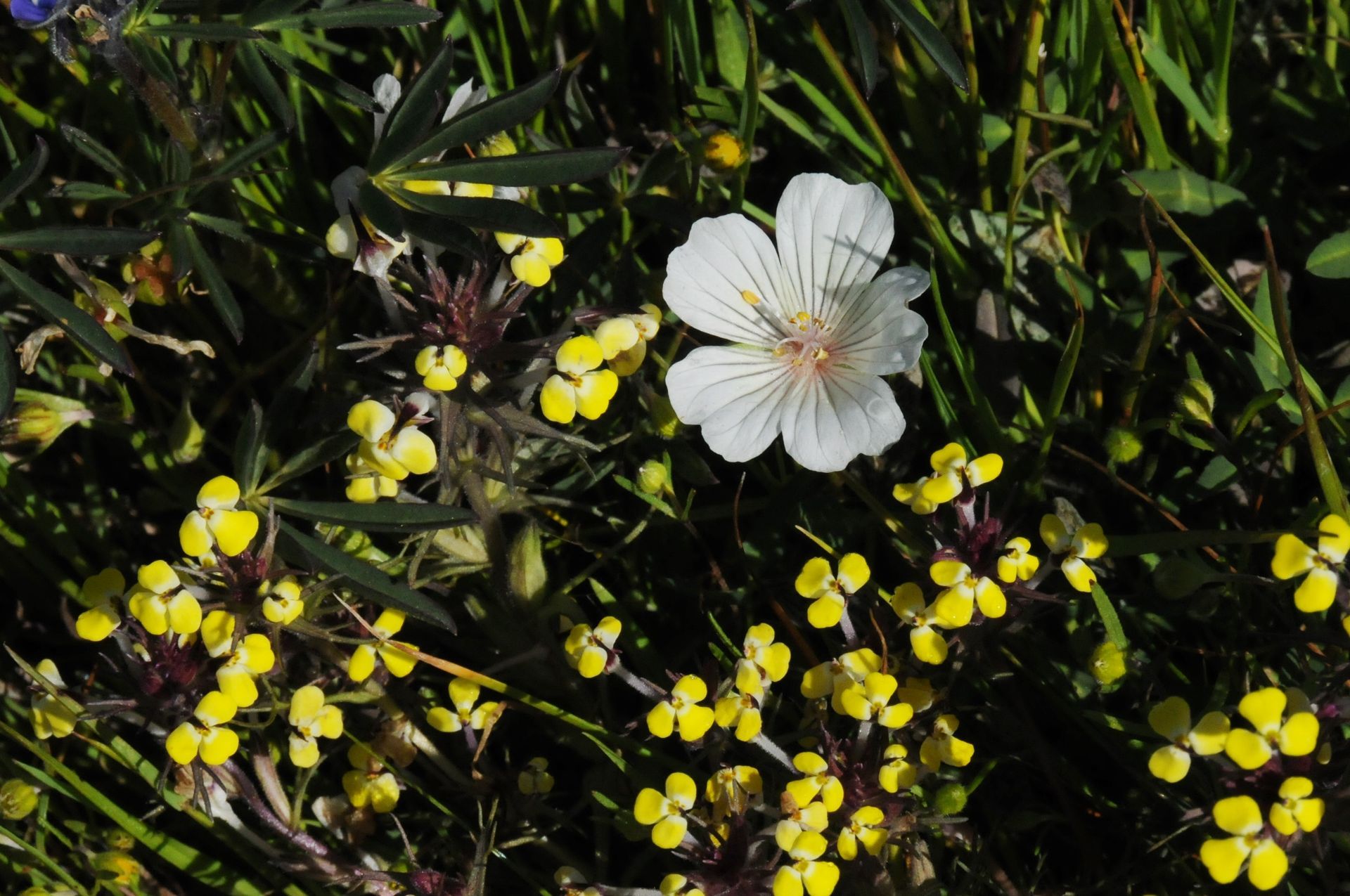
Meadowfoam (Limnanthes douglasii) and Butter & Eggs (Triphysaria eriantha) are two wildflowers found in vernal pools

Often categorized with coral reefs and rainforests, wetlands are one of the most productive ecosystems in the world. Not only do they provide food and shelter for countless species ranging from invertebrates to humans; but wetland plants and soils also function as biological filters that purify the surface water. They do this by removing destructively high levels of nitrogen and phosphorus before it percolates back into underground aquifers. Ducks Unlimited has documented that some wetland plants have shown to have heavy metal concentrations 100,000 times higher than found in the surrounding water.


And speaking of underground water storage, many wetlands are directly responsible for recharging the water stored underground which is used for drinking and crop irrigation. Wetlands also function as flood control. A recent study found that one acre of wetland can store over 1.5 million gallons of water. Inland wetlands such as seasonal and perennial ponds, and vernal pools and swales breakup and slow down surface flow reducing the severity of flash floods as well as aiding in decreasing the effects of drought.


Wetland soils are unique themselves. The texture, composition and color differ from the surrounding upland soils because of the anaerobic conditions and components that make up the wetland soil. One of the most highly specialized, strikingly beautiful and unfortunately rare types of wetlands in California are vernal pools. Vernal (which means “spring” in latin) pools are depressions that occur most commonly in clay soils. Vernal pools have three seasons: wet, flowering and dry. During the rainy season, the pools fill and hold water through the wet weather. As rainfall decreases and temperatures increase, the water level begins to decline. This is when the specially-adapted plants, most of which are native, begin to flower often resulting in stunning concentric rings of color. As the water evaporates and the soils dry out, the plants die but their seeds are ready and waiting for the next wet season to begin.


Fairy shrimp are invertebrates that also inhabit vernal pools. Most of their activity happens while the pool is still ponded and some species can complete their life cycles in as few as 16 days! Fairy shrimp cysts, embryos encased in hard shells, are designed to survive drought and can lay in the cracked, desiccated bottom of vernal pools for over one hundred years waiting for the perfect conditions to reoccur. If those conditions, usually a combination of ponding depth and duration, temperature and water quality occur, young fairy shrimp emerge and eventually mate resulting in more cysts and future fairy shrimp populations. California is home to several species of fairy shrimp, unfortunately most of them are listed as threatened or endangered due to habitat destruction.


Since about the mid 1800’s, California has lost roughly 95% of the documented historic four million acres of wetlands. Less than 200 years ago, much of the Valley was covered with what is known as Tulare Lake, an inland freshwater lake fed by rain fall and snow melt. Once one of the largest freshwater lakes in the United States, its marshy edges were lined with cattails, tules and other wetland and riparian vegetation. The lake and its extensive marshes supported the Yokuts with materials and food including tule, fish, deer and elk for centuries and was an important stop-over for thousands of migrating birds along the Pacific Flyway.


Over time, the lake and associated wetland areas were altered in order to farm the fertile soil beneath the water and build cities and towns. Historically, seasonal flood events had doused the surrounding land with fertile river sediments. Gold mining and associated activities left sediment deposits about a mile wide and three feet thick at some locations in the Valley, blocking the drainages and channels that moved and circulated the water; literally raising the level of the land.


Today, only five percent or so of wetlands that remain intact are protected by law although they face threats from development, climate change, and drought. Education and awareness have helped raise public appreciation for wetland habitats which in turn helps the species that rely on them for part or their entire life cycle. In addition to preservation, wetland construction has also added to the inventory of functioning, healthy wetlands in California.


Did you know that the Woodland Regional Park Preserve has naturally occurring vernal pools as well as restored and constructed seasonal and perennial wetlands? The seasonal and perennial wetlands are in the process of being populated by both wildlife and vegetation. If you’d like to see the establishment of a wetland and help us document the prosperity and popularity, please let us know. The WRPP will be opening to the public soon but if you just can’t wait that long, visit our website or give us a call to schedule a tour of the park preserve. We can’t wait to show you what we and our partners have done!


-Kristie Ehrhardt; kehrhardt@tuleyome.org


Tuleyome Land Conservation Program Manager

RECENT ARTICLES

By Nate Lillge August 6, 2025
Bill Grabert is stepping down from his position as treasurer on Tuleyome’s volunteer Board of Directors – we thank him for his many years of service! Bill first joined Tuleyome as a staff member in 2016. His nature-based teaching influenced many youth over the years with school field trips throughout the Berryessa Snow Mountain National Monument region, from Redbud Trail to Conaway Ranch. As part of Tuleyome’s team of instructors for the California Certified Naturalist program, Bill inspired adults to care for the region. His love of the area began as soon as he graduated from college and began working as a geologist in Lake County. Bill has devoted his diverse knowledge and skillset to care for, steward, and enjoy California’s northern Inner Coast Range Mountains for many years. He will be missed on the Board but we look forward to seeing him on the trails! -Nate Lillge (Adventures and Engagement Director)  and Lyndsay Dawkins (Volunteer Tuleyome Board President)
By Bryan Pride August 6, 2025
Fifty-eight and a half million acres of America's wildest forests have been protected for nearly 25 years by the Roadless Rule, a conservation cornerstone that could soon disappear. Established in 2001, the Roadless Area Conservation Rule (RACR) , more commonly known as the Roadless Rule, designated "Inventoried Roadless Areas" (IRAs) across our nation's forests, prohibiting new roads from being built. Now, USDA Secretary Rollins wants to rescind it . From Alaska to California, the losses from this rollback would be massive. In Alaska, 92% of the Tongass National Forest could lose protection, threatening one of the world's most pristine ecosystems and the indigenous communities who call it home. California would lose protections across 4.4 million acres spanning 21 national forests , which has the potential to impact treasured places like Inyo, Shasta-Trinity, and the Berryessa Snow Mountain National Monument. Rule Born from Necessity, Not Ideology The Roadless Rule traces back to 1998, when U.S. Forest Service Chief Mike Dombeck saw the agency's vast road system as a major environmental and fiscal problem . To put this in perspective: the Forest Service maintains eight times more miles of road than the Interstate Highway System. The agency had too many roads to properly maintain for safety and environmental purposes, with poorly maintained roads contributing to erosion and other harms across national forests. The road maintenance backlog had ballooned to $8.4 billion while the agency received only 20% of the funding needed to maintain roads to environmental and safety standards. Dombeck proposed a moratorium on road construction in undeveloped forest areas across most of the National Forest System. The agency adopted an 18-month moratorium in February 1999 pending completion of an overall road management plan. Later that year, the agency undertook a rule making process to provide long-term administrative protection for roadless areas. The Forest Service conducted an extensive public involvement process that produced 1.7 million comments , with the majority favoring a strong national policy protecting roadless areas. The resulting Roadless Rule was not and is still not a blanket ban: it makes exceptions to allow access to non-federal land inholdings and pre-existing mineral leases, and allows logging to reduce fire risk, improve habitat or aid in the recovery of endangered species. What began as a fiscally prudent solution to an unwieldy road network became a cornerstone of forest conservation, one that Americans overwhelmingly supported then and continue to support today. The Administration's Claims vs. Reality According to USDA Secretary Rollins , the rule is “overly restrictive”, hinders fire prevention and responsible timber production, therefore the Rule poses “real harm to millions of acres of our national forests.” Rollins linked rescinding the Rule with Presidential Executive Order 14192, "Unleashing Prosperity Through Deregulation .” The reality is different. Rollins' claim ignores what's actually at stake. Roadless areas are essential ecosystems that provide clean air and water while keeping wilderness intact. They also serve as critical refuges for wildlife; 57% of America's most vulnerable species depend on roadless areas for habitat. For the 156 million Americans who visit national forests annually, these areas offer irreplaceable backcountry recreation experiences. Most strikingly, the administration's fire prevention argument is backwards. Scientific research reveals that 88% of wildfires are human-caused , and 95% of these fires start within half a mile of a road. Areas closest to roads experience 53% more fires than would occur by random chance. Less than 3% of wildfires start in wilderness areas more than a mile from roads. This research indicates that more roads through our forests are more likely to increase fires and would outweigh the effects of improving fire containment. While the administration claims roads improve fire response, fire management teams consistently identify inadequate resources and personnel shortages, not roads , as the primary barriers to effective wildfire management . Rather than building roads that increase fire risk, fire management experts advocate for investing in cultural and prescribed burns, fire mitigation and forest restoration, proven approaches that are underfunded but key to preventing future fires and reducing fire magnitude. What's Next? Rescinding the Roadless Rule will require a public comment period that has yet to be announced. This is when we can all share our views. Tuleyome will be following this issue closely and will be commenting. For more information on the Roadless Rule and how to participate in the public comment process or other advocacy opportunities, contact B ryan Pr ide .
By Kristie Ehrhardt August 6, 2025
The short answer is honestly, pretty much anywhere! Because the 344,476 acre Berryessa Snow Mountain National Monument (the Monument) is located in the rural areas of Colusa, Glenn, Lake, Mendocino, Napa, Solano and Yolo counties you will have a great view of the dark night sky, free from urban light pollution from virtually anywhere within its boundaries! The Monument is an easy drive from not only the metropolitan Sacramento area but also from the San Francisco Bay Area as well as the North Bay communities making it an easy day trip. If you’re here especially for the Perseid meteor shower though it might be a very long day since best viewing happens between the hours of midnight and early morning. If you’re adventurous and up for an all-nighter, be certain to pack plenty of water and snacks and be sure to pull over only where it is safe and you’re not blocking a road, especially when it’s dark. Also always keep safety in mind and look out for wildlife as the Monument is home to black bears, mountain lions, coyotes, tule elk and bobcats that may be traveling through the area as well. If you’d like to stay a night (or several), there are multiple developed campgrounds to choose from inside the Monument boundaries. If you’re up camping, check out The Blue Oaks Campground, Indian Valley Campground, Hunting Creek Campground, Deer Valley Campground, Lower Nye Campground, West Crocket Campground or Kowalski Camping area just to name a few of the sites available for overnight stays. Before you go though, please do check with the United States Forest Service or the Bureau of Land Management websites for details on the particular camping area you’re interested in as well as current conditions, requirements and fire restrictions. The Monument also offers primitive camping in the three wilderness areas located within the Monument boundaries. Cache Creek Wilderness, Cedar Roughs Wilderness and Snow Mountain Wilderness present nearly unlimited opportunities for dispersed camping or backcountry camping (areas located outside of designated campgrounds). Although camping is allowed and encouraged, these areas have no amenities such as tables, toilets, available water or waste removal and require you to pack out all trash and waste. There are no motorized vehicles allowed within Wilderness areas and they provide places for deep solitude with nature. Camping in Wilderness areas or other dispersed camping areas require visitors to understand and follow the Leave No Trace principles of outdoor recreating as well as planning ahead and knowing the area and what to pack. That said, other than the trees potentially blocking some of the night sky, you’re sure to avoid urban light pollution and have an unobstructed view of the night sky from practically anywhere within the Monument! -Kristie Ehrhardt ( kehrhardt@tuleyome.org ) Tuleyome Land Conservation Program Manager