Tuleyome's Science Corner - Sandhill Cranes

Kristie Ehrhardt • November 9, 2023

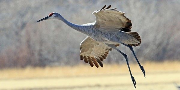
Sandhill Crane by Bob Zeller, National Wildlife Federation

When is the last time you saw a real-live dinosaur? I’m guessing it’s been a while, am I right? If you’d like to get an up close and personal look at a living fossil, look no farther than the wetlands and surrounding habitat types of California’s Central Valley. Sandhill Cranes (Antigone canadensis) are among the oldest living bird species on Earth. Beginning in October, their arrival from their northern breeding grounds creates quite a spectacle as thousands upon thousands of these giant birds arrive in the Central Valley to spend the winter. Their homecoming is announced by their unique and thunderous bugling calls. 


There are 15 species of cranes world-wide with only two species occurring in the United States; Sandhill Cranes and Whooping Cranes. There are three migrating subpopulations of Sandhill Cranes: Lesser, Greater and Canadian, and three non-migratory subpopulations: Mississippi, Florida and Cuban, each occurring in their namesake locations. Both the Mississippi and Cuban subpopulations are critically endangered. Of the three migrating subpopulations, it is the Greater subpopulation that winters here in our region. During the cranes’ migration back to their breeding grounds in the spring, tens of thousands of them congregate along the Platte River in Nebraska. It is there that a fossil from a Sandhill Crane relative estimated to be approximately ten million (!) years old was found.


This living fossil belongs to the taxonomic order Gruiformes which dates back to shortly after the end of the dinosaurs, about 60 million years ago. The oldest conclusive Sandhill Crane fossil dates back about two and a half million years while most modern-day birds’ lineage dates back to less than two million years ago, proving Sandhill Cranes to be much older than most bird species.


Sandhill Cranes are large bulky birds with wingspans from five to seven feet. They stand about five feet tall and can weigh up to twelve pounds. Adults boast mainly slate gray plumage that may be streaked with mud, long necks with pale cheeks, an unmistakable bright crimson cap and their illustrious “bustle” of longer feathers covering their rears. Juveniles have the same gray plumage minus the red cap with the addition of a rusty wash on their on their wings, neck, back and tops of their heads. They are impressive fliers and take advantage of thermals and currents, staying aloft for hours without exerting unnecessary energy. They generally cover up to 300 miles in a single day but some have gone as far as 500 miles with a helpful tailwind. They fly with their necks outstretched and their feet and legs trailing behind them filling the skies with their shape and trumpeting sounds. 


Sandhill Cranes are social and live in pairs or with their family groups, but when it is time to make the journey to their wintering grounds, large groups of unrelated cranes come together to migrate, forage and roost as one extensive unit. They mate for life and use their calls along with their elaborate and graceful dance moves to court and secure their life partners. Once bonded, the pairs build grand, mounded nests made of sedges, reeds and grasses in wetlands or the surrounding uplands. One to three eggs are laid and will hatch about a month later. As is common with ground-nesting birds, the hatchlings begin wandering from the nest after only a few hours. The young begin to fly at about three months of age, but remain with the parents during migration and for the remainder of the year until the next clutch is laid the following season. They are omnivores and their diet changes with their locations and the seasons. While in California they forage for seeds, plants, worms, snails, reptiles, amphibians, and small mammals in open grasslands, fields and wetlands. Sandhill Cranes are famous for their rolling, reverberating calls which are a result of their anatomy. Their trachea is very long and coils into their breast bone which lowers the pitch and amplifies the sound of their call which can be heard for long distances.


They’re only here for a short time and if you’d like to see how special they are just visit the Woodbridge Ecological Reserve and/or the Cosumnes River Preserve from October through February. Cosumnes River Preserve offers guided Sandhill Crane tours. Note, you will need a Lands Pass, or a hunting or fishing license to enter the Woodbridge Ecological Reserve. And, although they’re enormous, you’ll kick yourself if you forget your binoculars!


-Kristie Ehrhardt (kehrhardt@tuleyome.org)


Tuleyome Land Conservation Program Manager

RECENT ARTICLES

By Nate Lillge August 6, 2025
Bill Grabert is stepping down from his position as treasurer on Tuleyome’s volunteer Board of Directors – we thank him for his many years of service! Bill first joined Tuleyome as a staff member in 2016. His nature-based teaching influenced many youth over the years with school field trips throughout the Berryessa Snow Mountain National Monument region, from Redbud Trail to Conaway Ranch. As part of Tuleyome’s team of instructors for the California Certified Naturalist program, Bill inspired adults to care for the region. His love of the area began as soon as he graduated from college and began working as a geologist in Lake County. Bill has devoted his diverse knowledge and skillset to care for, steward, and enjoy California’s northern Inner Coast Range Mountains for many years. He will be missed on the Board but we look forward to seeing him on the trails! -Nate Lillge (Adventures and Engagement Director)  and Lyndsay Dawkins (Volunteer Tuleyome Board President)
By Bryan Pride August 6, 2025
Fifty-eight and a half million acres of America's wildest forests have been protected for nearly 25 years by the Roadless Rule, a conservation cornerstone that could soon disappear. Established in 2001, the Roadless Area Conservation Rule (RACR) , more commonly known as the Roadless Rule, designated "Inventoried Roadless Areas" (IRAs) across our nation's forests, prohibiting new roads from being built. Now, USDA Secretary Rollins wants to rescind it . From Alaska to California, the losses from this rollback would be massive. In Alaska, 92% of the Tongass National Forest could lose protection, threatening one of the world's most pristine ecosystems and the indigenous communities who call it home. California would lose protections across 4.4 million acres spanning 21 national forests , which has the potential to impact treasured places like Inyo, Shasta-Trinity, and the Berryessa Snow Mountain National Monument. Rule Born from Necessity, Not Ideology The Roadless Rule traces back to 1998, when U.S. Forest Service Chief Mike Dombeck saw the agency's vast road system as a major environmental and fiscal problem . To put this in perspective: the Forest Service maintains eight times more miles of road than the Interstate Highway System. The agency had too many roads to properly maintain for safety and environmental purposes, with poorly maintained roads contributing to erosion and other harms across national forests. The road maintenance backlog had ballooned to $8.4 billion while the agency received only 20% of the funding needed to maintain roads to environmental and safety standards. Dombeck proposed a moratorium on road construction in undeveloped forest areas across most of the National Forest System. The agency adopted an 18-month moratorium in February 1999 pending completion of an overall road management plan. Later that year, the agency undertook a rule making process to provide long-term administrative protection for roadless areas. The Forest Service conducted an extensive public involvement process that produced 1.7 million comments , with the majority favoring a strong national policy protecting roadless areas. The resulting Roadless Rule was not and is still not a blanket ban: it makes exceptions to allow access to non-federal land inholdings and pre-existing mineral leases, and allows logging to reduce fire risk, improve habitat or aid in the recovery of endangered species. What began as a fiscally prudent solution to an unwieldy road network became a cornerstone of forest conservation, one that Americans overwhelmingly supported then and continue to support today. The Administration's Claims vs. Reality According to USDA Secretary Rollins , the rule is “overly restrictive”, hinders fire prevention and responsible timber production, therefore the Rule poses “real harm to millions of acres of our national forests.” Rollins linked rescinding the Rule with Presidential Executive Order 14192, "Unleashing Prosperity Through Deregulation .” The reality is different. Rollins' claim ignores what's actually at stake. Roadless areas are essential ecosystems that provide clean air and water while keeping wilderness intact. They also serve as critical refuges for wildlife; 57% of America's most vulnerable species depend on roadless areas for habitat. For the 156 million Americans who visit national forests annually, these areas offer irreplaceable backcountry recreation experiences. Most strikingly, the administration's fire prevention argument is backwards. Scientific research reveals that 88% of wildfires are human-caused , and 95% of these fires start within half a mile of a road. Areas closest to roads experience 53% more fires than would occur by random chance. Less than 3% of wildfires start in wilderness areas more than a mile from roads. This research indicates that more roads through our forests are more likely to increase fires and would outweigh the effects of improving fire containment. While the administration claims roads improve fire response, fire management teams consistently identify inadequate resources and personnel shortages, not roads , as the primary barriers to effective wildfire management . Rather than building roads that increase fire risk, fire management experts advocate for investing in cultural and prescribed burns, fire mitigation and forest restoration, proven approaches that are underfunded but key to preventing future fires and reducing fire magnitude. What's Next? Rescinding the Roadless Rule will require a public comment period that has yet to be announced. This is when we can all share our views. Tuleyome will be following this issue closely and will be commenting. For more information on the Roadless Rule and how to participate in the public comment process or other advocacy opportunities, contact B ryan Pr ide .
By Kristie Ehrhardt August 6, 2025
The short answer is honestly, pretty much anywhere! Because the 344,476 acre Berryessa Snow Mountain National Monument (the Monument) is located in the rural areas of Colusa, Glenn, Lake, Mendocino, Napa, Solano and Yolo counties you will have a great view of the dark night sky, free from urban light pollution from virtually anywhere within its boundaries! The Monument is an easy drive from not only the metropolitan Sacramento area but also from the San Francisco Bay Area as well as the North Bay communities making it an easy day trip. If you’re here especially for the Perseid meteor shower though it might be a very long day since best viewing happens between the hours of midnight and early morning. If you’re adventurous and up for an all-nighter, be certain to pack plenty of water and snacks and be sure to pull over only where it is safe and you’re not blocking a road, especially when it’s dark. Also always keep safety in mind and look out for wildlife as the Monument is home to black bears, mountain lions, coyotes, tule elk and bobcats that may be traveling through the area as well. If you’d like to stay a night (or several), there are multiple developed campgrounds to choose from inside the Monument boundaries. If you’re up camping, check out The Blue Oaks Campground, Indian Valley Campground, Hunting Creek Campground, Deer Valley Campground, Lower Nye Campground, West Crocket Campground or Kowalski Camping area just to name a few of the sites available for overnight stays. Before you go though, please do check with the United States Forest Service or the Bureau of Land Management websites for details on the particular camping area you’re interested in as well as current conditions, requirements and fire restrictions. The Monument also offers primitive camping in the three wilderness areas located within the Monument boundaries. Cache Creek Wilderness, Cedar Roughs Wilderness and Snow Mountain Wilderness present nearly unlimited opportunities for dispersed camping or backcountry camping (areas located outside of designated campgrounds). Although camping is allowed and encouraged, these areas have no amenities such as tables, toilets, available water or waste removal and require you to pack out all trash and waste. There are no motorized vehicles allowed within Wilderness areas and they provide places for deep solitude with nature. Camping in Wilderness areas or other dispersed camping areas require visitors to understand and follow the Leave No Trace principles of outdoor recreating as well as planning ahead and knowing the area and what to pack. That said, other than the trees potentially blocking some of the night sky, you’re sure to avoid urban light pollution and have an unobstructed view of the night sky from practically anywhere within the Monument! -Kristie Ehrhardt ( kehrhardt@tuleyome.org ) Tuleyome Land Conservation Program Manager