Tuleyome Tale: The Importance of Trail Work at Knoxville Management Area

Nate Lillge • September 21, 2023

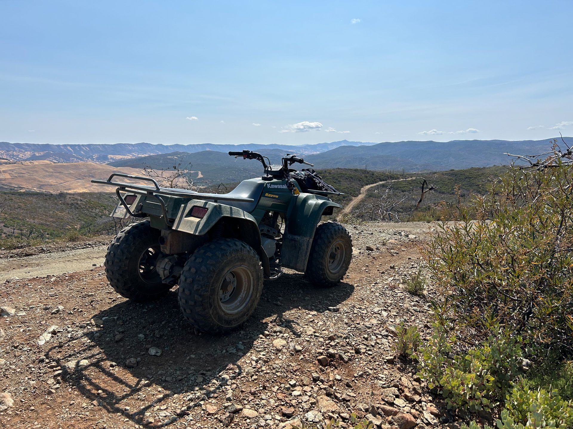
OHV on Dunnigan Hill Road with Berryessa Peak in the background

Located between Lake Berryessa and Clear Lake is the Bureau of Land Management’s Knoxville Management Area. This area, which is included in Berryessa Snow Mountain National Monument, is popular with off-highway vehicle (OHV) users from around Clear Lake to the Sacramento region and San Francisco Bay area. The 17,700 acres is fee-free, making it very attractive to all users - OHV riders, hunters, mountain bikers, and campers.


Knoxville, like the rest of the Berryessa Snow Mountain National Monument region, has been home to native people for many thousands of years. What we see as OHV trails today, were likely footpaths that the Patwin, Pomo, Miwok, and other people used as trade and travel routes. Some of these may then have been used by miners looking for mercury and other materials before being turned into the roads and trails that exist today.


Knoxville Management Area has been impacted by recent wildfires, including the 2020 LNU Complex Fire, and subsequent rains. Fire is a stressor on the ecosystem and the following rains can cause significant erosion, limiting regrowth. Trails have been closed in Knoxville to allow vegetation a chance to regrow in burned areas, to repopulate fire breaks, and to repair the trails. Bringing these communities back is key to decreasing erosion, which protects Knoxville’s natural and cultural resources. Fire is a common part of this cycle, just not to the degree we are seeing recently.


Fire-caused vegetation loss and improperly developed and constructed roads has led to increased erosion throughout Knoxville Management Area and downstream water quality has suffered. Tuleyome is leading a pair of projects to improve recreational experiences and access while reducing erosion and improving water quality downstream. Rolling dips, armored crossings, and other measures will increase the durability of trails while preventing water from becoming channelized and creating gullies along the trail.

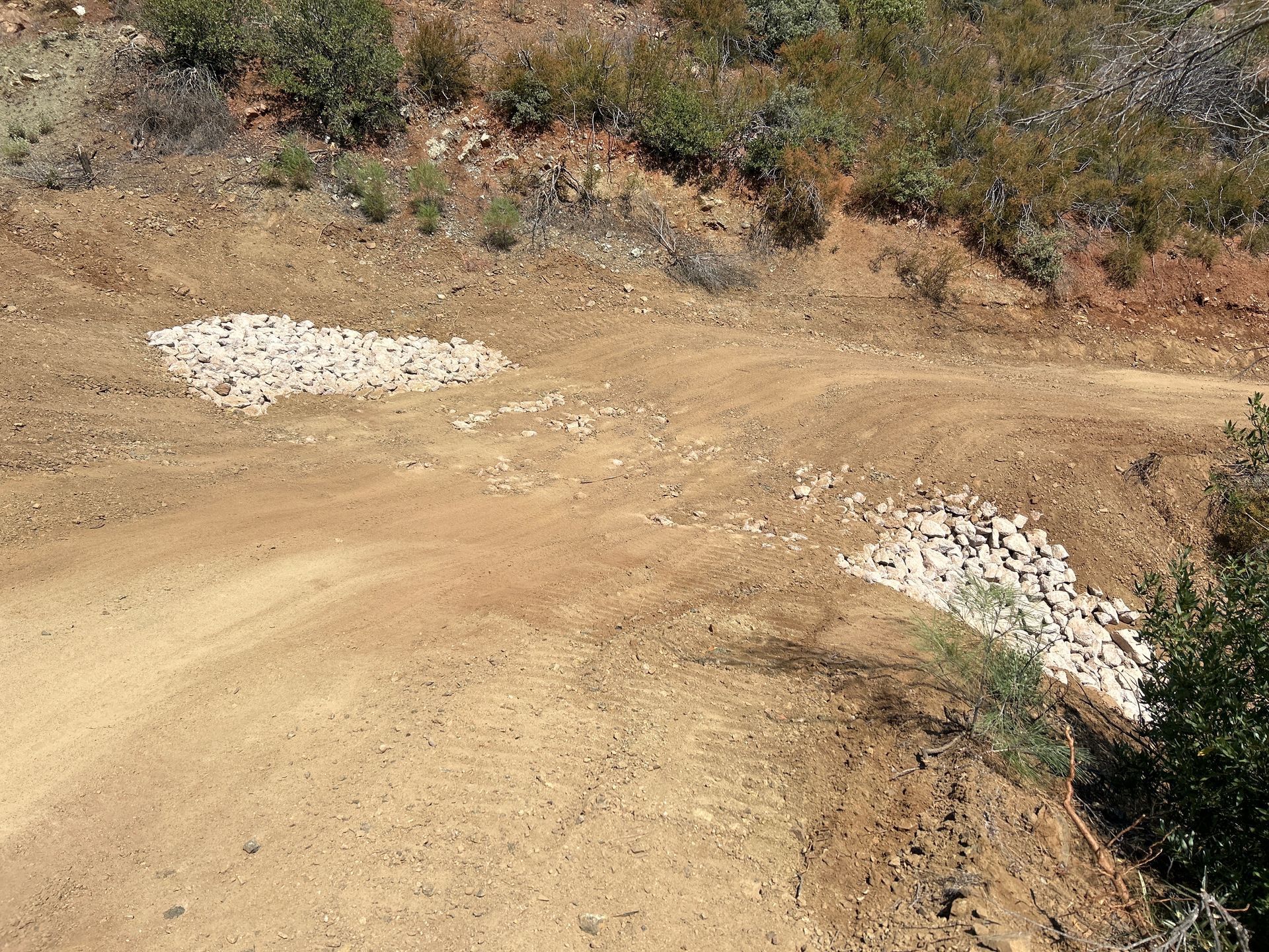
Armored crossing on Dunnigan Hill Road

Placing rolling dips at regular intervals decreases the amount of water flowing on the trail, decreases the speed of flow, and lessens the erosive force. Armored crossings, rocks added to the trail bed where water flows across the trail, stabilize the soil and keep water flowing across the trail instead of following it. These can replace culverts which may become plugged by debris, melt, or collapse due to age.


Native Americans have used what is now Knoxville Management Area for thousands of years. Because of this, there are cultural resources scattered throughout the area. Local tribes have been consulted and are working with Tuleyome, BLM, and the contractors to ensure that these resources are respected and preserved.

Rolling Dip on Dunnigan Hill Road

Dunnigan Hill Road, from the northern entrance to Hunting Creek Camp, and Hunting Creek Road, from Hunting Creek to the intersection with Devilhead Road, is open for OHV use. The four-mile Cedar Creek Trail remains closed to allow the newly added structures to solidify.


More information about the projects is available on Tuleyome’s website. Visit the Bureau of Land Management website for more information about Knoxville Management Area.


-Nate Lillge (nlillge@tuleyome.org)


Tuleyome Adventures and Engagement Director


Certified California Naturalist

RECENT ARTICLES

By Geoff Benn June 4, 2026
A beaver at Conaway Ranch We’ve got new footage from our game cameras at Conaway Ranch! This camera site was chosen by 4 th graders from Dingle Elementary during a recent field trip to Conaway. The camera is near the otter slide we’ve previously filmed, but is a few feet away from the entrance to the slide, allowing us to film the animals as they approach. We saw beaver, otter, a fox, a raccoon, and more! Click here to watch the video . Tuleyome works with Conaway Preservation Group to offer educational programs at Conaway Ranch, including programs for K-12 groups and the general public. If you have any questions about the game camera footage or our programs at Conaway, please reach out to Education Associate Geoff Benn at gbenn@tuleyome.org.
June 4, 2026
The current administration has released its proposed budget for the 2027 fiscal year. It proposes drastic cuts to our public land management agencies. The proposed budget would significantly reduce funding for the Bureau of Land Management (BLM), including a 34% cut to its total budget, a 27% staff cut, a 76% cut to the National Conservation Lands, which encompass 38 million acres of protected public lands, a 61% cut to recreation management (including campsites and trails), and total elimination of funding for cultural resources and wilderness management. It also would shift priorities towards extractive uses of public lands instead of conservation and clean energy. The administration’s budget would also drastically cut funding to the U.S. Forest Service (USFS), eliminate several offices, state and federal research stations (six in California) and transfer all fire fighting to BLM. Notably, in the face of all these cuts, the budget would increase funding for extractive industries; funding for timber sales would increase 450%. The reductions and policy changes would impair these agencies’ abilities to protect public lands, cultural resources, fresh water sources, and wildlife, while also impairing access to them and recreation on them. The President’s budget is now in Congress, where committees in both the Senate and the House of Representatives are amending and voting on the bills in preparation for full House and Senate votes. Now is the time to take action for our public lands and the environment by urging Congress to reject the proposed budget and maintain funding for BLM, USFS, and programs that protect and steward our public lands. Let your representatives know that you oppose the cuts to BLM and USFS and the rollbacks to our public land protections. And let them know why these special places are important to them. You can voice your opinions to Congress in multiple ways. You can: Call their offices Send a letter to Congress - we’ve pulled together a template for you to use, but don’t forget to let them know why public lands are important to you – download sample letter here Contact them on social media Meet with a representative in their District offices. Don’t know how to reach them, go to Congress.gov and find their phone numbers, addresses, district offices, websites and so much more if you’re interested. Now is the time to speak up for our public lands! Mary Lamborn (Communications Intern) and Sandra Schubert (Executive Director)
By Kristie Ehrhardt June 4, 2026
You betcha! Wild carrot, also known as Queen Anne’s Lace, is a common sight within the Berryessa Snow Mountain National Monument region. With its straight and sturdy stalk, bright green, frilly leaves and white, flat-topped flower clusters, it is identifiable even from the limited viewing scope of a traveling car. Queen Anne’s Lace ( Daucus carota ) belongs to the Apiaceae (carrot) family. All members of this family display flower clusters arranged in an upside-down umbrella shape called an umbel. It is native to Europe and is the plant that tasty cultivated carrots originated from. It was brought to North America for its medicinal purposes and has since naturalized across the continent in disturbed and natural areas in mountains, valleys and coastal areas. It can be so prolific that it outcompetes native plants and can also be mildly toxic to livestock. Queen Anne’s Lace is an herbaceous biennial (it doesn’t flower until its second year and then dies) that can reach up to four feet tall in optimum conditions. The stem of the plant is bright green, straight and sturdy and is covered in short, coarse hairs which is a very helpful identifier. I recently learned a clever and helpful quip that I will never forget: Queen Anne has hairy legs (referring to the hair along the stems of the plant)! The tiny, white flowers all originate from the same point and splay out in an airy, flat topped cluster (umbel). Another identifying feature is that oftentimes (but not always) the flower umbels often have a single dark purple flower in the center of the cluster. This purple flower is not always present but when it is it can be used to positively identify the plant as Queen Anne’s lace. The leaves are finely divided which gives them a lacy appearance and look almost identical to our cultivated carrot plants. Although wild carrots are edible, the whitish tap root isn’t as robust or flavorful as the cultivated carrots we are used to. Warning! There are plants such as poison hemlock that are incredibly similar looking so eating things in nature is never advised unless you can absolutely identify them! Poison hemlock has basically the same growth pattern as wild carrot however the stem of poison hemlock lacks the tiny hairs and mature plants have very definite purple splotches up and down the stems. All parts of poison hemlock are toxic but it is particularly potent in the seeds and roots. Poison hemlock is notoriously known as the poison that killed the Greek philosopher Socrates. Edible cousins of wild carrot include plants such as caraway, celery, parsley and parsnips. Although the root of the wild carrot plant is edible, contact with the sap may produce an allergic reaction in some individuals that are sensitive to it. Native pollinators such as butterflies and bees appreciate the abundance of flowers for their nectar. Wild carrot is currently blooming in all its glory so keep an eye out for it on your next trip to our favorite monument!