Monumental Anniversary (Questions)! - A Short History of the Berryessa Snow Mountain National Monument

Kristie Ehrhardt • July 2, 2025


As the old saying goes, time flies when you’re having fun! Can you believe it’s already been ten years since President Obama used the Antiquities Act to forever protect that special part of the Inner Coastal Range that we call the Berryessa Snow Mountain National Monument?! If you have been there, you probably understand and appreciate the importance of protecting this special place and if you haven’t been there, there is no time like the present to make the short drive to visit.


The birthplace of the Monument was at the ocean floor beginning 60 to 100 million years ago. Both Snow and Goat Mountains began as Jurassic seamounts that rose from the bottom of the ocean never reaching the surface of the water. The shifting of the North American and Pacific plates first pushed the seamounts back down below the ocean floor before once again pushing them back up, finally becoming the mountains we see today rising into the sky. California’s state rock, serpentinite, is visible throughout the Monument. It is the source of the region’s unique soils that support rare and endemic plant species contributing to extraordinary biodiversity. Due to the remarkable geology, the region’s hydrology is also notable; hosting multiple geothermal, mineral, carbonated and freshwater springs.


The region sustained Native Americans and their culture by providing nuts, seeds, grains and meat as well as shelter and materials used to make tools and assets for trading with other tribes. Traditional burning practices maintained the skillful balance between nature and man. Still evident to the experienced eye are many cultural resources sites within the Monument; mineral gathering, hunting and trading routes, camps and villages all preserved and protected.


Later came explorers, fur trappers, gold miners and ranchers. Shortly after, sawmills and railroads were constructed for timber harvest and around the turn of the 20th century people from all over came to steep in the therapeutic mineral-rich hot spring waters of the region. The native inhabitants of the Monument were displaced by the actions and activities of European settlers in the early to mid 1800’s yet the landscape still retains deep cultural significance for the 24 federally recognized tribes that call the region their indigenous home.


In 2015, President Obama recognized the need to preserve and protect, in perpetuity, this unique location for public welfare and enjoyment. The Berryessa Snow Mountain National Monument (Monument) is the quintessence of California’s wild Inner Coast Range hosting the headwaters of the Eel River, Cache, Putah and Stony Creeks. The region was once under ocean waters where geologic forces shaped and fashioned it into one of the most biologically diverse regions in California - a biological hotspot. The original boundaries established in 2015 included 330,780 acres of unbroken wildlands that sustain wildlife corridors and rare plant habitat. In 2024, President Biden extended the protection by including the 13,696 acres of Molok Luyuk. The Monument is a place sacred and significant to the Native American tribes including the Yuki, Nomlaki, Patwin, Pomo, Huchnom, Wappo and Lake Miwok that make up the very history of the Monument.


Paleontological studies have not only helped date the region but have also shown how tectonic plates have moved. A walk in the Monument is a stroll through millions of years of geological processes that have helped shape California. The dramatic topography is stunning from all angles. From nearly sea level in the valley, rolling hills, steep canyons, breathtaking ridgelines, to the East and West peaks of Snow Mountain that rise to more than 7,000 feet. Because of the diversity of habitat types, the Monument is also home to a variety of special-status wildlife species including Bald Eagles, Northern Spotted Owls and Tule Elk.


All of these combined have contributed to why the Berryessa Snow Mountain National Monument has been called the Crown Jewel of Northern California’s Inner Coast Range!


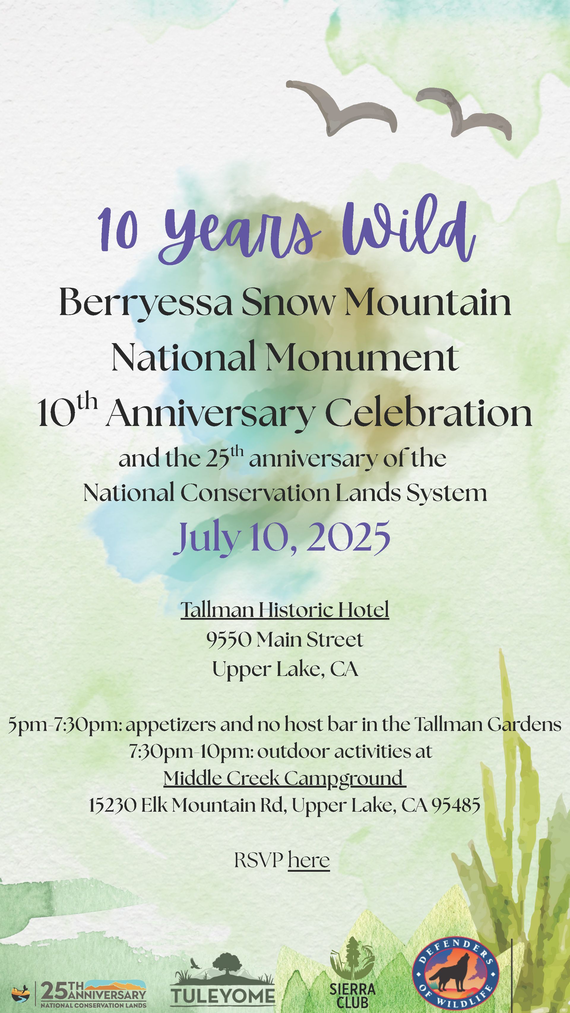
Please join us on July 10, 2025 at the Tallman Hotel in Upper Lake at 5 pm for a Monumental celebration to commemorate the 10th anniversary of our favorite monument!


We can’t wait to celebrate with you!


-Kristie Ehrhardt (kehrhardt@tuleyome.org)

Tuleyome Land Conservation Program Manager

RECENT ARTICLES

By Nate Lillge August 6, 2025
Bill Grabert is stepping down from his position as treasurer on Tuleyome’s volunteer Board of Directors – we thank him for his many years of service! Bill first joined Tuleyome as a staff member in 2016. His nature-based teaching influenced many youth over the years with school field trips throughout the Berryessa Snow Mountain National Monument region, from Redbud Trail to Conaway Ranch. As part of Tuleyome’s team of instructors for the California Certified Naturalist program, Bill inspired adults to care for the region. His love of the area began as soon as he graduated from college and began working as a geologist in Lake County. Bill has devoted his diverse knowledge and skillset to care for, steward, and enjoy California’s northern Inner Coast Range Mountains for many years. He will be missed on the Board but we look forward to seeing him on the trails! -Nate Lillge (Adventures and Engagement Director)  and Lyndsay Dawkins (Volunteer Tuleyome Board President)
By Bryan Pride August 6, 2025
Fifty-eight and a half million acres of America's wildest forests have been protected for nearly 25 years by the Roadless Rule, a conservation cornerstone that could soon disappear. Established in 2001, the Roadless Area Conservation Rule (RACR) , more commonly known as the Roadless Rule, designated "Inventoried Roadless Areas" (IRAs) across our nation's forests, prohibiting new roads from being built. Now, USDA Secretary Rollins wants to rescind it . From Alaska to California, the losses from this rollback would be massive. In Alaska, 92% of the Tongass National Forest could lose protection, threatening one of the world's most pristine ecosystems and the indigenous communities who call it home. California would lose protections across 4.4 million acres spanning 21 national forests , which has the potential to impact treasured places like Inyo, Shasta-Trinity, and the Berryessa Snow Mountain National Monument. Rule Born from Necessity, Not Ideology The Roadless Rule traces back to 1998, when U.S. Forest Service Chief Mike Dombeck saw the agency's vast road system as a major environmental and fiscal problem . To put this in perspective: the Forest Service maintains eight times more miles of road than the Interstate Highway System. The agency had too many roads to properly maintain for safety and environmental purposes, with poorly maintained roads contributing to erosion and other harms across national forests. The road maintenance backlog had ballooned to $8.4 billion while the agency received only 20% of the funding needed to maintain roads to environmental and safety standards. Dombeck proposed a moratorium on road construction in undeveloped forest areas across most of the National Forest System. The agency adopted an 18-month moratorium in February 1999 pending completion of an overall road management plan. Later that year, the agency undertook a rule making process to provide long-term administrative protection for roadless areas. The Forest Service conducted an extensive public involvement process that produced 1.7 million comments , with the majority favoring a strong national policy protecting roadless areas. The resulting Roadless Rule was not and is still not a blanket ban: it makes exceptions to allow access to non-federal land inholdings and pre-existing mineral leases, and allows logging to reduce fire risk, improve habitat or aid in the recovery of endangered species. What began as a fiscally prudent solution to an unwieldy road network became a cornerstone of forest conservation, one that Americans overwhelmingly supported then and continue to support today. The Administration's Claims vs. Reality According to USDA Secretary Rollins , the rule is “overly restrictive”, hinders fire prevention and responsible timber production, therefore the Rule poses “real harm to millions of acres of our national forests.” Rollins linked rescinding the Rule with Presidential Executive Order 14192, "Unleashing Prosperity Through Deregulation .” The reality is different. Rollins' claim ignores what's actually at stake. Roadless areas are essential ecosystems that provide clean air and water while keeping wilderness intact. They also serve as critical refuges for wildlife; 57% of America's most vulnerable species depend on roadless areas for habitat. For the 156 million Americans who visit national forests annually, these areas offer irreplaceable backcountry recreation experiences. Most strikingly, the administration's fire prevention argument is backwards. Scientific research reveals that 88% of wildfires are human-caused , and 95% of these fires start within half a mile of a road. Areas closest to roads experience 53% more fires than would occur by random chance. Less than 3% of wildfires start in wilderness areas more than a mile from roads. This research indicates that more roads through our forests are more likely to increase fires and would outweigh the effects of improving fire containment. While the administration claims roads improve fire response, fire management teams consistently identify inadequate resources and personnel shortages, not roads , as the primary barriers to effective wildfire management . Rather than building roads that increase fire risk, fire management experts advocate for investing in cultural and prescribed burns, fire mitigation and forest restoration, proven approaches that are underfunded but key to preventing future fires and reducing fire magnitude. What's Next? Rescinding the Roadless Rule will require a public comment period that has yet to be announced. This is when we can all share our views. Tuleyome will be following this issue closely and will be commenting. For more information on the Roadless Rule and how to participate in the public comment process or other advocacy opportunities, contact B ryan Pr ide .
By Kristie Ehrhardt August 6, 2025
The short answer is honestly, pretty much anywhere! Because the 344,476 acre Berryessa Snow Mountain National Monument (the Monument) is located in the rural areas of Colusa, Glenn, Lake, Mendocino, Napa, Solano and Yolo counties you will have a great view of the dark night sky, free from urban light pollution from virtually anywhere within its boundaries! The Monument is an easy drive from not only the metropolitan Sacramento area but also from the San Francisco Bay Area as well as the North Bay communities making it an easy day trip. If you’re here especially for the Perseid meteor shower though it might be a very long day since best viewing happens between the hours of midnight and early morning. If you’re adventurous and up for an all-nighter, be certain to pack plenty of water and snacks and be sure to pull over only where it is safe and you’re not blocking a road, especially when it’s dark. Also always keep safety in mind and look out for wildlife as the Monument is home to black bears, mountain lions, coyotes, tule elk and bobcats that may be traveling through the area as well. If you’d like to stay a night (or several), there are multiple developed campgrounds to choose from inside the Monument boundaries. If you’re up camping, check out The Blue Oaks Campground, Indian Valley Campground, Hunting Creek Campground, Deer Valley Campground, Lower Nye Campground, West Crocket Campground or Kowalski Camping area just to name a few of the sites available for overnight stays. Before you go though, please do check with the United States Forest Service or the Bureau of Land Management websites for details on the particular camping area you’re interested in as well as current conditions, requirements and fire restrictions. The Monument also offers primitive camping in the three wilderness areas located within the Monument boundaries. Cache Creek Wilderness, Cedar Roughs Wilderness and Snow Mountain Wilderness present nearly unlimited opportunities for dispersed camping or backcountry camping (areas located outside of designated campgrounds). Although camping is allowed and encouraged, these areas have no amenities such as tables, toilets, available water or waste removal and require you to pack out all trash and waste. There are no motorized vehicles allowed within Wilderness areas and they provide places for deep solitude with nature. Camping in Wilderness areas or other dispersed camping areas require visitors to understand and follow the Leave No Trace principles of outdoor recreating as well as planning ahead and knowing the area and what to pack. That said, other than the trees potentially blocking some of the night sky, you’re sure to avoid urban light pollution and have an unobstructed view of the night sky from practically anywhere within the Monument! -Kristie Ehrhardt ( kehrhardt@tuleyome.org ) Tuleyome Land Conservation Program Manager