Science Corner - Blue Elderberry

Kristie Ehrhardt • May 9, 2025


The Blue Elderberry (Sambucus mexicana, also known as Sambucus nigra ssp. carfulea) is a deciduous shrub that belongs to the honeysuckle, sometimes called muskroot, family (Caprifoliaceae). The family contains five genuses with about 200 species.


Blue Elderberry is widely distributed throughout the southwestern United States and occurs in Arizona, California, New Mexico, Texas and regions in Mexico. It occurs throughout California in a variety of habitat types but is regionally rare in southeastern California. The Blue Elderberry is hardy and sprouts quickly and easily. Although it is native to California, I’ve heard it described as “weedy” - which would normally imply that a species is not native - because it is so prolific. It can be found in a variety of habitat types with well-drained soil including streambanks and at the bottom of canyons and slopes. It prefers full sun but can still thrive in partial to full shade. In our region it is commonly found as an understory species in riparian habitats but is also found in chaparral, sage scrub, woodland and grasslands as well.


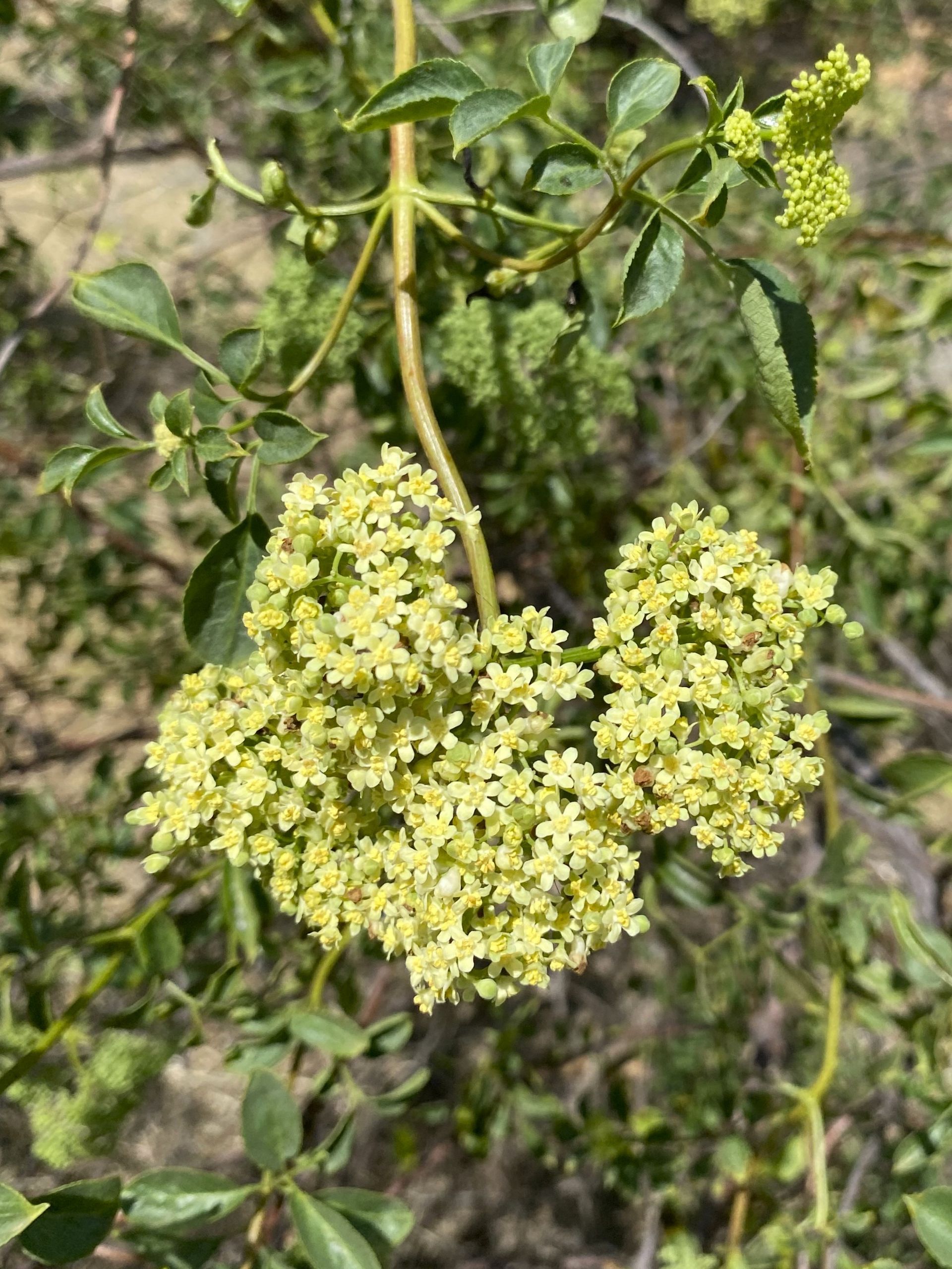
Blue Elderberries (elderberry) are often multi stem shrubs but individuals will occasionally develop a main trunk like a small tree. A mature elderberry can get up to 30 feet tall but most range from eight to around 20 feet in height. It is generally as wide as it is tall, flowers from March through September and fruits from July through October. The leaves are pinnately compound, similar to the leaf of a walnut tree with roughly five to nine leaflets. The creamy white flowers occur in flat-topped clusters and the fruit is a small, very dark blue or purple berry with dense, short white hairs making the berries look frosted. Elderberries are easy to grow and hardy. They do well in native landscape and they are receptive to pruning if you use them in your yard. They require moderate watering but once established only need infrequent waterings.


Elderberry flowers are readily edible and can be steeped into tea to help with cold, flu and fever symptoms and even have skin care benefits. The rest of the plant contains the alkaloids hydrocyanic acid and sambucine. Both of these will cause nausea, and nobody wants that. The fruit is high in vitamin C and can only be eaten if they are cooked. They have been used in a variety of ways including syrup, jellies, wine, candy, pies, sauces and tinctures. Because of the alkaloids, eating unripe, raw berries causes violent illness. Side note - a former coworker has personal experience with this and does not recommend it. The bark has medicinal purposes but it also contains a high concentration of cyanide and must be prepared carefully. Native Americans used the flowers to reduce bleeding and congestion and to reduce headache. The leaves were used to help wounds, sprains and bruises heal and berries were used for food, to dye baskets, to help burns heal along with other medicinal purposes. The wood was used for arrow shafts, flues, whistles, clapper sticks as well as medicinal uses.


Elderberry shrubs are an important food source for a variety of wildlife. Bats, bees and butterflies gather nectar from the flowers and the shrub itself provides habitat for many different wildlife species. Birds, squirrels and other rodents and even bears gorge themselves on the berries which aids in the distribution of the shrubs to other locations. Many songbird species benefit from eating elderberries in the summer months including bluebirds, flickers, mockingbirds, scrub jays, sparrows, towhees, and waxwings. Deer and elk readily graze on the foliage. Elderberry shrubs also provide soil stabilization on stream and river banks while the canopy provides shade to cool the ground and nearby water.


The Valley Elderberry Longhorn Beetle (Desmocerus californicus dimorphus) is a native species that requires the Blue Elderberry shrub to complete its life cycle. The Valley Elderberry Longhorn Beetle (VELB) was listed as a threatened species under the Federal Endangered Species Act on August 8, 1980 and is only found on the Valley floor and low foothills. VELB live exclusively on Elderberry shrubs and spend their entire lives on them. Adults emerge from inside the stems of Elderberry shrubs from March to about June. The adults mate and lay eggs on the bark of the shrub. After the eggs hatch, the larvae excavate a tunnel into the pith of the plant where they stay and feed for up to two years. When the larvae are ready to pupate they tunnel to the surface and excavate an exit hole then fill the hole with frass (wood shavings) and return to their pupal chamber inside the plant. As mating season begins, the adult beetle dislodges the frass plug, exits the shrub and the cycle begins again. The primary threat to the VELB is habitat fragmentation and loss and herbicide and insecticide use. As a result of the protections afforded the beetle, the shrub has also benefited.


-Kristie Ehrhardt (kehrhardt@tuleyome.org)

Tuleyome Land Conservation Program Manager

RECENT ARTICLES

By Nate Lillge August 6, 2025
Bill Grabert is stepping down from his position as treasurer on Tuleyome’s volunteer Board of Directors – we thank him for his many years of service! Bill first joined Tuleyome as a staff member in 2016. His nature-based teaching influenced many youth over the years with school field trips throughout the Berryessa Snow Mountain National Monument region, from Redbud Trail to Conaway Ranch. As part of Tuleyome’s team of instructors for the California Certified Naturalist program, Bill inspired adults to care for the region. His love of the area began as soon as he graduated from college and began working as a geologist in Lake County. Bill has devoted his diverse knowledge and skillset to care for, steward, and enjoy California’s northern Inner Coast Range Mountains for many years. He will be missed on the Board but we look forward to seeing him on the trails! -Nate Lillge (Adventures and Engagement Director)  and Lyndsay Dawkins (Volunteer Tuleyome Board President)
By Bryan Pride August 6, 2025
Fifty-eight and a half million acres of America's wildest forests have been protected for nearly 25 years by the Roadless Rule, a conservation cornerstone that could soon disappear. Established in 2001, the Roadless Area Conservation Rule (RACR) , more commonly known as the Roadless Rule, designated "Inventoried Roadless Areas" (IRAs) across our nation's forests, prohibiting new roads from being built. Now, USDA Secretary Rollins wants to rescind it . From Alaska to California, the losses from this rollback would be massive. In Alaska, 92% of the Tongass National Forest could lose protection, threatening one of the world's most pristine ecosystems and the indigenous communities who call it home. California would lose protections across 4.4 million acres spanning 21 national forests , which has the potential to impact treasured places like Inyo, Shasta-Trinity, and the Berryessa Snow Mountain National Monument. Rule Born from Necessity, Not Ideology The Roadless Rule traces back to 1998, when U.S. Forest Service Chief Mike Dombeck saw the agency's vast road system as a major environmental and fiscal problem . To put this in perspective: the Forest Service maintains eight times more miles of road than the Interstate Highway System. The agency had too many roads to properly maintain for safety and environmental purposes, with poorly maintained roads contributing to erosion and other harms across national forests. The road maintenance backlog had ballooned to $8.4 billion while the agency received only 20% of the funding needed to maintain roads to environmental and safety standards. Dombeck proposed a moratorium on road construction in undeveloped forest areas across most of the National Forest System. The agency adopted an 18-month moratorium in February 1999 pending completion of an overall road management plan. Later that year, the agency undertook a rule making process to provide long-term administrative protection for roadless areas. The Forest Service conducted an extensive public involvement process that produced 1.7 million comments , with the majority favoring a strong national policy protecting roadless areas. The resulting Roadless Rule was not and is still not a blanket ban: it makes exceptions to allow access to non-federal land inholdings and pre-existing mineral leases, and allows logging to reduce fire risk, improve habitat or aid in the recovery of endangered species. What began as a fiscally prudent solution to an unwieldy road network became a cornerstone of forest conservation, one that Americans overwhelmingly supported then and continue to support today. The Administration's Claims vs. Reality According to USDA Secretary Rollins , the rule is “overly restrictive”, hinders fire prevention and responsible timber production, therefore the Rule poses “real harm to millions of acres of our national forests.” Rollins linked rescinding the Rule with Presidential Executive Order 14192, "Unleashing Prosperity Through Deregulation .” The reality is different. Rollins' claim ignores what's actually at stake. Roadless areas are essential ecosystems that provide clean air and water while keeping wilderness intact. They also serve as critical refuges for wildlife; 57% of America's most vulnerable species depend on roadless areas for habitat. For the 156 million Americans who visit national forests annually, these areas offer irreplaceable backcountry recreation experiences. Most strikingly, the administration's fire prevention argument is backwards. Scientific research reveals that 88% of wildfires are human-caused , and 95% of these fires start within half a mile of a road. Areas closest to roads experience 53% more fires than would occur by random chance. Less than 3% of wildfires start in wilderness areas more than a mile from roads. This research indicates that more roads through our forests are more likely to increase fires and would outweigh the effects of improving fire containment. While the administration claims roads improve fire response, fire management teams consistently identify inadequate resources and personnel shortages, not roads , as the primary barriers to effective wildfire management . Rather than building roads that increase fire risk, fire management experts advocate for investing in cultural and prescribed burns, fire mitigation and forest restoration, proven approaches that are underfunded but key to preventing future fires and reducing fire magnitude. What's Next? Rescinding the Roadless Rule will require a public comment period that has yet to be announced. This is when we can all share our views. Tuleyome will be following this issue closely and will be commenting. For more information on the Roadless Rule and how to participate in the public comment process or other advocacy opportunities, contact B ryan Pr ide .
By Kristie Ehrhardt August 6, 2025
The short answer is honestly, pretty much anywhere! Because the 344,476 acre Berryessa Snow Mountain National Monument (the Monument) is located in the rural areas of Colusa, Glenn, Lake, Mendocino, Napa, Solano and Yolo counties you will have a great view of the dark night sky, free from urban light pollution from virtually anywhere within its boundaries! The Monument is an easy drive from not only the metropolitan Sacramento area but also from the San Francisco Bay Area as well as the North Bay communities making it an easy day trip. If you’re here especially for the Perseid meteor shower though it might be a very long day since best viewing happens between the hours of midnight and early morning. If you’re adventurous and up for an all-nighter, be certain to pack plenty of water and snacks and be sure to pull over only where it is safe and you’re not blocking a road, especially when it’s dark. Also always keep safety in mind and look out for wildlife as the Monument is home to black bears, mountain lions, coyotes, tule elk and bobcats that may be traveling through the area as well. If you’d like to stay a night (or several), there are multiple developed campgrounds to choose from inside the Monument boundaries. If you’re up camping, check out The Blue Oaks Campground, Indian Valley Campground, Hunting Creek Campground, Deer Valley Campground, Lower Nye Campground, West Crocket Campground or Kowalski Camping area just to name a few of the sites available for overnight stays. Before you go though, please do check with the United States Forest Service or the Bureau of Land Management websites for details on the particular camping area you’re interested in as well as current conditions, requirements and fire restrictions. The Monument also offers primitive camping in the three wilderness areas located within the Monument boundaries. Cache Creek Wilderness, Cedar Roughs Wilderness and Snow Mountain Wilderness present nearly unlimited opportunities for dispersed camping or backcountry camping (areas located outside of designated campgrounds). Although camping is allowed and encouraged, these areas have no amenities such as tables, toilets, available water or waste removal and require you to pack out all trash and waste. There are no motorized vehicles allowed within Wilderness areas and they provide places for deep solitude with nature. Camping in Wilderness areas or other dispersed camping areas require visitors to understand and follow the Leave No Trace principles of outdoor recreating as well as planning ahead and knowing the area and what to pack. That said, other than the trees potentially blocking some of the night sky, you’re sure to avoid urban light pollution and have an unobstructed view of the night sky from practically anywhere within the Monument! -Kristie Ehrhardt ( kehrhardt@tuleyome.org ) Tuleyome Land Conservation Program Manager