Science Corner - Osprey in Berryessa Snow Mountain National Monument

Kristie Ehrhardt • July 2, 2025


If you’ve spent time near the water while visiting Berryessa Snow Mountain National Monument, chances are you may have observed one of our native raptor species nearby. Sometimes called fish hawk, sea hawk or river hawk, Osprey are found in temperate and tropical regions of every continent except Antarctica. They are the second most wide-spread species of raptor and one of only six land birds with global distribution. There are four subspecies: Eurasian, American, Caribbean and Australian, each looking remarkably similar with only minor physical differences.


The subspecies of Osprey found within Berryessa Snow Mountain National Monument (and the rest of the United States and Canada) are the American Osprey (Pandion haliaetus carolinensis). Originally classified as a species of falcon, today Osprey are the sole member of the genus Pandion and the only member of the family Panionidae. Nearly all subspecies of Osprey are migratory and travel long distances to winter in warmer climates, however, most of the individuals that call Berryessa Snow Mountain National Monument (Monument) home are year-long residents. In fact, some populations from farther north may travel to our region and farther south to winter there.


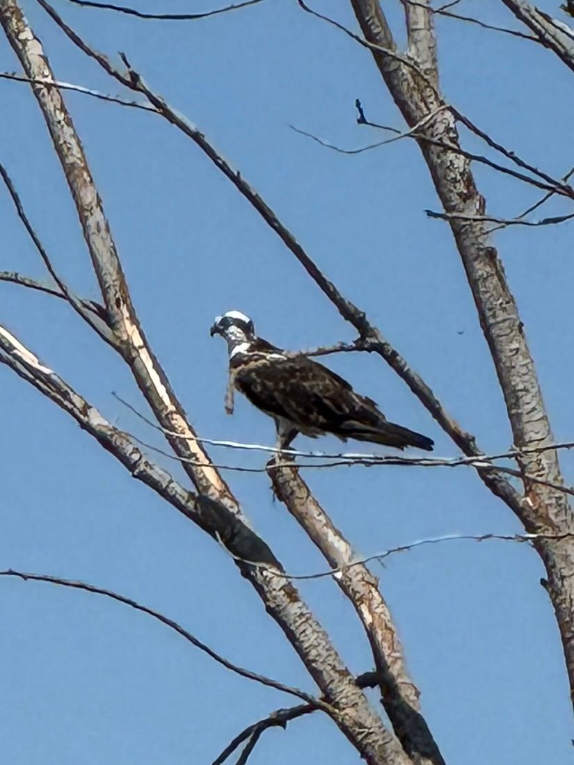
Osprey are smaller than a bald eagle but larger than a red-tailed hawk. They range from about 21 to 23 inches in length with a wingspan of from 50 to over 70 inches. They weigh between two and a half up to four pounds with the females being slightly larger than the males. Males and females look very similar with dark brown underparts and a white breast both which serve as field marks to help identify them in flight. Females usually have brown streaking on the upper portion of their breast. Their heads are brilliant white with a striking dark mask across the eyes and down the sides of the neck. This mask reduces glare to allow them to see fish in the water better, similar to an athlete wearing “eye black”. They have golden brown irises with black beaks, blue ceres and black feet and talons and a short, rounded tail. In flight they hold their wings form an arch, similar to a gull.


Osprey are considered piscivorous meaning that their diet consists almost exclusively of fish and they have several unique adaptations to allow them to be efficient and extremely successful predators. Osprey and owls are the only two raptors (bird of prey) with a reversible outer toe which means it can face forward or backward helping them capture and control slippery fish with two toes in front and two toes in back if needed. They also have sharp spicules and barbed scales on the underside of their feet that also help grasp wet, wriggling fish and their nostrils seal tightly to keep water out when they plunge feet first after prey. Osprey also have specialized vision that helps them see prey species underwater from up to 100 feet above the surface. You may have seen them hover for a bit and dive at rates of up to 50 miles per hour, but what you may not have noticed is how they are able to adjust their flight angle to account for the distortion caused by the refracted image. Often becoming fully submerged, their dense plumage is oily to help shed water. After a successful dive, Osprey will carry their prey to a nearby perch or back to the nest.


Osprey breed near lakes and rivers but can also be found nesting near coastal brackish waters. Flirting begins with the male calling while performing aerial stunts and the offering of a stick in his beak. If the female is impressed, she will accept the stick and the two begin a lifelong chick-rearing relationship. Nests or eyries are constructed in the tops of trees, on rocky outcrops, the tops of utility poles, duck blinds and platforms intended for them to nest on. Males will carry in material which may consist of sticks, driftwood, reeds, lichen, seaweed or even urban trash such as plastic bags and nylon netting while the female arranges it. Nests are remodeled and updated year after year, some have been used by different pairs for as many as 70 years. Over time they become so big - up to six feet in diameter and weigh nearly 300 pounds - and so messy that other species such as tree swallows and grackles build their own nests inside them! Two to four eggs are laid and the female stays with the chicks while the male brings food back to the nest. Chicks begin to fledge after about two months.


Many Native American tribes consider the Osprey a species of eagles and give them the same reverence as Bald or Golden Eagles. Coastal tribal legends often consider Osprey a guardian and others consider them medicine birds and seeing one in a vision meant that the person had been granted spiritual power as a healer.


Osprey were almost extirpated during the late 18th and 19th century due to egg collecting and hunting and then again during the 1960’s and 70’s because of the use of the insecticide dichlorodiphenytrichloroethane (DDT), which interfered with the calcium absorption in many species of bird causing fatal egg shell thinning. Fortunately, Osprey adapt well to life near humans and will readily use man-made nesting structures which has helped the population rebound following the banning of DDT use.


Fun Osprey Facts:

  • When flying with a fish, Osprey turn them so they are face first to reduce wind resistance
  • Migrants travel individually rather than in flocks and follow the edges of bodies of water such as coastlines, lake shores, rivers and mountain ridges.
  • The oldest known Osprey was over 25 years old and was banded in Virginia in 1973
  • Bald Eagles sometimes chase Ospreys to steal their catch


A not so fun fact is that “Osprey plumes” were used to decorate hats in the 19th century. Despite their name, the feathers were actually from egrets which caused a sharp decline in the number of egrets.


Be sure to keep an eye out for Osprey next time you visit our favorite monument!


-Kristie Ehrhardt (kehrhardt@tuleyome.org)

Tuleyome Land Conservation Program Manager

RECENT ARTICLES

By Nate Lillge August 6, 2025
Bill Grabert is stepping down from his position as treasurer on Tuleyome’s volunteer Board of Directors – we thank him for his many years of service! Bill first joined Tuleyome as a staff member in 2016. His nature-based teaching influenced many youth over the years with school field trips throughout the Berryessa Snow Mountain National Monument region, from Redbud Trail to Conaway Ranch. As part of Tuleyome’s team of instructors for the California Certified Naturalist program, Bill inspired adults to care for the region. His love of the area began as soon as he graduated from college and began working as a geologist in Lake County. Bill has devoted his diverse knowledge and skillset to care for, steward, and enjoy California’s northern Inner Coast Range Mountains for many years. He will be missed on the Board but we look forward to seeing him on the trails! -Nate Lillge (Adventures and Engagement Director)  and Lyndsay Dawkins (Volunteer Tuleyome Board President)
By Bryan Pride August 6, 2025
Fifty-eight and a half million acres of America's wildest forests have been protected for nearly 25 years by the Roadless Rule, a conservation cornerstone that could soon disappear. Established in 2001, the Roadless Area Conservation Rule (RACR) , more commonly known as the Roadless Rule, designated "Inventoried Roadless Areas" (IRAs) across our nation's forests, prohibiting new roads from being built. Now, USDA Secretary Rollins wants to rescind it . From Alaska to California, the losses from this rollback would be massive. In Alaska, 92% of the Tongass National Forest could lose protection, threatening one of the world's most pristine ecosystems and the indigenous communities who call it home. California would lose protections across 4.4 million acres spanning 21 national forests , which has the potential to impact treasured places like Inyo, Shasta-Trinity, and the Berryessa Snow Mountain National Monument. Rule Born from Necessity, Not Ideology The Roadless Rule traces back to 1998, when U.S. Forest Service Chief Mike Dombeck saw the agency's vast road system as a major environmental and fiscal problem . To put this in perspective: the Forest Service maintains eight times more miles of road than the Interstate Highway System. The agency had too many roads to properly maintain for safety and environmental purposes, with poorly maintained roads contributing to erosion and other harms across national forests. The road maintenance backlog had ballooned to $8.4 billion while the agency received only 20% of the funding needed to maintain roads to environmental and safety standards. Dombeck proposed a moratorium on road construction in undeveloped forest areas across most of the National Forest System. The agency adopted an 18-month moratorium in February 1999 pending completion of an overall road management plan. Later that year, the agency undertook a rule making process to provide long-term administrative protection for roadless areas. The Forest Service conducted an extensive public involvement process that produced 1.7 million comments , with the majority favoring a strong national policy protecting roadless areas. The resulting Roadless Rule was not and is still not a blanket ban: it makes exceptions to allow access to non-federal land inholdings and pre-existing mineral leases, and allows logging to reduce fire risk, improve habitat or aid in the recovery of endangered species. What began as a fiscally prudent solution to an unwieldy road network became a cornerstone of forest conservation, one that Americans overwhelmingly supported then and continue to support today. The Administration's Claims vs. Reality According to USDA Secretary Rollins , the rule is “overly restrictive”, hinders fire prevention and responsible timber production, therefore the Rule poses “real harm to millions of acres of our national forests.” Rollins linked rescinding the Rule with Presidential Executive Order 14192, "Unleashing Prosperity Through Deregulation .” The reality is different. Rollins' claim ignores what's actually at stake. Roadless areas are essential ecosystems that provide clean air and water while keeping wilderness intact. They also serve as critical refuges for wildlife; 57% of America's most vulnerable species depend on roadless areas for habitat. For the 156 million Americans who visit national forests annually, these areas offer irreplaceable backcountry recreation experiences. Most strikingly, the administration's fire prevention argument is backwards. Scientific research reveals that 88% of wildfires are human-caused , and 95% of these fires start within half a mile of a road. Areas closest to roads experience 53% more fires than would occur by random chance. Less than 3% of wildfires start in wilderness areas more than a mile from roads. This research indicates that more roads through our forests are more likely to increase fires and would outweigh the effects of improving fire containment. While the administration claims roads improve fire response, fire management teams consistently identify inadequate resources and personnel shortages, not roads , as the primary barriers to effective wildfire management . Rather than building roads that increase fire risk, fire management experts advocate for investing in cultural and prescribed burns, fire mitigation and forest restoration, proven approaches that are underfunded but key to preventing future fires and reducing fire magnitude. What's Next? Rescinding the Roadless Rule will require a public comment period that has yet to be announced. This is when we can all share our views. Tuleyome will be following this issue closely and will be commenting. For more information on the Roadless Rule and how to participate in the public comment process or other advocacy opportunities, contact B ryan Pr ide .
By Kristie Ehrhardt August 6, 2025
The short answer is honestly, pretty much anywhere! Because the 344,476 acre Berryessa Snow Mountain National Monument (the Monument) is located in the rural areas of Colusa, Glenn, Lake, Mendocino, Napa, Solano and Yolo counties you will have a great view of the dark night sky, free from urban light pollution from virtually anywhere within its boundaries! The Monument is an easy drive from not only the metropolitan Sacramento area but also from the San Francisco Bay Area as well as the North Bay communities making it an easy day trip. If you’re here especially for the Perseid meteor shower though it might be a very long day since best viewing happens between the hours of midnight and early morning. If you’re adventurous and up for an all-nighter, be certain to pack plenty of water and snacks and be sure to pull over only where it is safe and you’re not blocking a road, especially when it’s dark. Also always keep safety in mind and look out for wildlife as the Monument is home to black bears, mountain lions, coyotes, tule elk and bobcats that may be traveling through the area as well. If you’d like to stay a night (or several), there are multiple developed campgrounds to choose from inside the Monument boundaries. If you’re up camping, check out The Blue Oaks Campground, Indian Valley Campground, Hunting Creek Campground, Deer Valley Campground, Lower Nye Campground, West Crocket Campground or Kowalski Camping area just to name a few of the sites available for overnight stays. Before you go though, please do check with the United States Forest Service or the Bureau of Land Management websites for details on the particular camping area you’re interested in as well as current conditions, requirements and fire restrictions. The Monument also offers primitive camping in the three wilderness areas located within the Monument boundaries. Cache Creek Wilderness, Cedar Roughs Wilderness and Snow Mountain Wilderness present nearly unlimited opportunities for dispersed camping or backcountry camping (areas located outside of designated campgrounds). Although camping is allowed and encouraged, these areas have no amenities such as tables, toilets, available water or waste removal and require you to pack out all trash and waste. There are no motorized vehicles allowed within Wilderness areas and they provide places for deep solitude with nature. Camping in Wilderness areas or other dispersed camping areas require visitors to understand and follow the Leave No Trace principles of outdoor recreating as well as planning ahead and knowing the area and what to pack. That said, other than the trees potentially blocking some of the night sky, you’re sure to avoid urban light pollution and have an unobstructed view of the night sky from practically anywhere within the Monument! -Kristie Ehrhardt ( kehrhardt@tuleyome.org ) Tuleyome Land Conservation Program Manager