Tuleyome 's Science Corner: California's Big Trees

Kristie Ehrhardt • May 11, 2022

Giant Sequoia (Sequoiadendron giganteum)

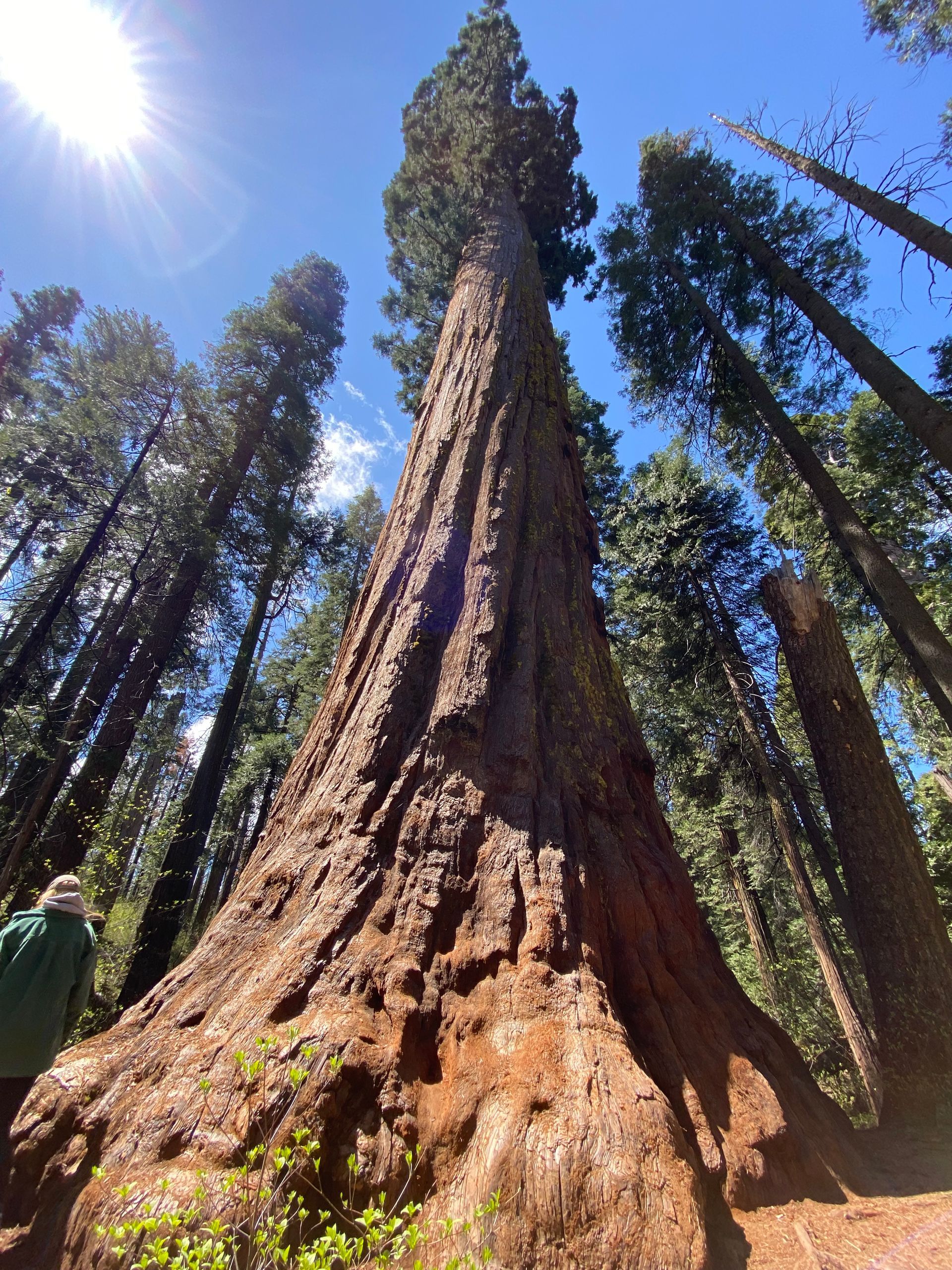
Not only does California have the oldest living trees (Great Basin Bristlecone Pine, Pinus longaeva) and the tallest living trees (Coastal Redwood, Sequoia sempervirens) but we also have the largest living trees – The Giant Sequoia. The giant sequoia (Sequoiadendron giganteum) has many common names but the best one is simply “big trees” given to them by John Muir. It is the only surviving species in the genus Sequoiadendron and the most massive tree on Earth, in fact they are the largest living things ever to exist on Earth. The fossil record for the redwood family dates back 180 million years to the dinosaurs and individuals can live over 3,000 years. The oldest living giant sequoia is about 3,250 years old. Once wide spread, today they’re found in only 75 groves on the western slope of the Sierra Nevada, always near a reliable source of water. They are listed as an endangered species and only about 80,000 trees remain.


Giant sequoias have both male and female cones. The roughly two-inch long female cones produce the seeds but that can only happen if pollen from the much smaller male cones is blown close enough to make contact with the female cones. Once fertilized, the seeds stay within the cone for two years until they are mature. When mature, the seeds are still so tiny that they resemble a flake of oatmeal and weigh only 1/6,000 of an ounce. After they mature, the cones stay on the trees for 20 years or more until they are knocked off by wind, snow or even a small native squirrel, called a chickaree. A mature tree may produce 40,000 cones all at once but releases only about 1,500 a year, each cone containing about 200 tiny seeds. Once on the ground most seeds are released by the heat of fire or insect activity. Seedlings can begin to bear viable cones after about 12 years.


Although mature trees can be nearly 300 feet tall, their roots only extend down six to eight feet under the soil surface. Rather than having a long tap root like oaks do, the roots of the giant sequoia spread out laterally, sometimes to an area the size of an acre. This allows small feeder roots to absorb nutrients and water from the surrounding soil. The wide network of roots along with their sturdy, symmetrical trunks allow the giant trees stability. If the tree is weakened by burn scars or other injuries, or the roots are eroded or weakened by fungus, the tree can emphatically come crashing down in a severe wind storm. In fact, falling over is one of the few things that can kill a giant sequoia.


In many ways the giant sequoia has adapted to live with fire. The bark is thick, nearly three feet thick on some trees, fibrous and furrowed and the sap contains high levels of tannic acid; both which help protect the trees from fire. The tannins also cause fallen trees to take a very long time to decompose, sometimes several hundred years or more. The massive branches, some six feet in diameter are located high above the ground, closer to the top of the tree, to help keep flames from reaching the crown. The shape of the trunk also helps other burning trees to roll off if they happen to fall on a giant sequoia.


Not only have giant sequoias evolved with the presence of fire, they actually benefit from small, frequent fires. Fire burns much of the debris on the ground that can hamper a tiny seed from germinating and receiving sunlight on the forest floor. The heat from fires also signals the cones to release their seeds. When settlers came to California, fires were suppressed resulting in a high fuel load and more severe, uncontrollable fires that could damage the giant trees. Three major fires, the Castle Fire (2020), the KNP Complex Fire and the Windy Fire (both 2021) are responsible for killing 14,000 of the 80,000 remaining giant sequoias. 


Giant sequoias do not grow in pure stands like coastal redwoods do. They occur as part of the Sierra mixed conifer forest alongside sugar pines (Pinus lambertiana), white firs (Abies concolor), incense cedars (Calocedruus decurrens), ponderosa pines (Pinus ponderosa), mountain dogwood (Cornus nuttallii), Pacific yew (Taxus brevifolia) and hazelnut (Corylus cornutta var. californica) between 2,000 and 7,000 feet in elevation.


There are several places to visit the giant trees but the closest is the Calaveras Big Trees State Park located in Arnold, only a two-hour drive from Sacramento.


-Kristie Ehrhardt; kehrhardt@tuleyome.org


Tuleyome Land Conservation Program Manager

RECENT ARTICLES

June 5, 2025
We extend our thanks and gratitude to Stephen McCord as he ends his tenure on the Tuleyome Board of Directors. Stephen has applied his energy and expertise to fulfilling Tuleyome’s mission for many years. In 2016 he managed the first Tuleyome mercury mine remediation project at the Corona/Twin Peaks Mine. He followed that with work on Tuleyome trail projects in the Knoxville Off-Highway Vehicle Area, riding all the trails on his own adventure motorcycle. As a Tuleyome representative, he’s taken many community members on hikes in Berryessa Snow Mountain National Monument and the surrounding areas. Stephen has over 20 years of environmental engineering experience, in California and worldwide. He has overseen extensive projects in water quality field work, management and cleanup, and has applied his knowledge to policy development, analysis and technical support. In short, Stephen is a consummate environmental and water engineer, and he brought his expertise to Tuleyome’s many projects. In 2023 Stephen joined the Board of Directors and agreed to serve as President. He applied his supreme organizational skills to managing board duties and activities. He also brought an optimism to the board about what can be accomplished with foresight, good planning and collaboration. Stephen has been a tireless advocate for Tuleyome, keeping the board on task even while handling numerous other professional responsibilities. Fortunately, although he is stepping down from the board, he will continue to support Tuleyome’s mission in many other ways. -Kim Longworth, Lyndsay Dawkins and Bill Grabert Volunteer Tuleyome Board members 
By Geoff Benn June 5, 2025
A river otter making its way up the slide. Looking to take a break with some cute video content? This month we placed game cameras looking into an otter slide at Conaway Ranch. Otter slides are paths worn into riverbanks by repeated use by otters and other animals. The slides at Conaway are quite active, so we’ve been able to get some great footage, including otters, beavers, racoons, snakes, and more! 
By Bryan Pride June 5, 2025
Since April 2024, America's public lands had something they'd never had before: a rule that treated conservation as equal to all other land uses. The Public Lands Rule , introduced by the Biden Administration, formally recognized conservation as a legitimate practice of multiple use, putting conservation on equal footing with recreation, grazing, and resource extraction. Built on decades of management experience and guided by science, data, and Indigenous knowledge, it gives land managers tools to maintain healthy ecosystems while supporting all the diverse ways we depend on public lands. It acknowledges a simple truth: conservation must be valued equally to all other land uses. Now there is growing pressure to rescind it. Why This Matters The environment around us is free-flowing, it's not confined to state borders or county lines. When mining operations contaminate watersheds in Northern California, it impacts the local businesses who depend on healthy rivers downstream, the agricultural communities that rely on clean water, and the families who've been camping along those waterways for generations. The Public Lands Rule recognized this interconnected reality and gave land managers agency to address problems before they spread across California's diverse landscapes, protecting the long-term viability of grazing allotments, recreation areas, and rural livelihoods that all depend on healthy public lands. This interconnected reality is exactly why the Public Lands Rule matters. The Rule is designed to ensure that the places we depend on, whether for weekend camping trips, or cattle grazing, stay healthy enough to support these uses long-term. When an area becomes overgrazed and doesn't recover, access to those grazing allotments is permanently lost, reducing ranchers' ability to maintain their livelihoods and harming local food production. Poor use or overuse of our public lands creates ripples of negative impact that hurt all communities. The Rule's main objective is simple but revolutionary: make sure our public lands stay productive for everyone who depends on them, rather than degrade them. The Rule created practical tools that built in accountability and prioritized future generations' access to healthy public lands. Restoration Leases : 10-year agreements allowing a variety of entities such as, conservation groups, tribes, and nonprofits to restore damaged landscapes—fires restoration, restoring wildlife habitats and cleaning up abandoned mining sites that currently scar some of our most beautiful public lands. Mitigation Leases : A tool that allows land users or other entities to offset impacts from their activities over specified time periods, creating partnerships between different land users and conservation groups to address environmental impacts on public lands. Strengthened Protection for Critical Areas : Clearer guidelines for protecting Areas of Critical Environmental Concern—the most special and fragile places that often provide the best wildlife viewing, the cleanest water sources, the most pristine camping experiences and the richest biodiversity. The False Dichotomy: Multiple Use vs. Conservation The main argument being used to encourage the rollback of the Public Lands Rule is " multiple use ", the legal principle requiring Bureau of Land Management (BLM) lands to serve many different purposes. The current Administration claims the Public Lands Rule hinders multiple uses of public lands. Why? The Rule calls for restoring degraded areas and making science based decisions. Contrary to their actual meaning, the current Administration interprets "restoring" and "science based decisions" as "locking up land". Land locking, where access gets completely cut off, is a real concern in some areas—it prevents both recreation and grazing. However, land locking is not what the Public Lands Rule promotes. In reality, it is promoting land healing. Take grazing for example. The Rule empowers BLM to use restoration leases in conjunction with existing grazing permittees to restore degraded rangeland. Monitoring who is grazing where and the number of permits issued for specific areas is a means to ensure sustainable grazing and prevent overuse. Many ranchers and land managers supported the Rule because they understand that healthy land is productive land. Overgrazing and environmental damage hurt their livelihoods too. The same principle applies to fire recovery. When public lands are damaged by sweeping wildfires, there is a need for active restoration: replanting native vegetation, stabilizing soils, removing hazardous debris. Restoration has to take place before safe recreation, grazing and other uses can resume. At times, restoration requires temporarily limiting access to burned areas as they recover. The goal is to allow for our lands to recover and heal before we start depending on them again with our multiple uses. Land restoration is not just limited to grazing or extraction; it is essential for recovering from wildfires. Whether it's grazing, recreation, or extraction, the Public Lands Rule isn't about stopping these uses, it's about understanding that healthy ecosystems are prerequisites for multiple use, not obstacles to it. You can't have sustainable grazing on degraded rangeland, quality recreation in fire damaged landscapes, or responsible extraction without considering long-term impacts We Are Public Stewards The Public Lands Rule represents a historic shift in how we value conservation, its potential rollback is a setback. But the vision it represents, conservation as a form of legitimate multiple use, remains essential and is not gone. As stewards of these 245 million acres, we have the power to practice conservation in our own actions and advocacy. Every time we practice Leave No Trace, support local businesses that operate responsibly on public lands, and make our voices heard in land management decisions, we're building the foundation for balanced stewardship that benefits everyone. Our public lands belong to all of us, which means we each have the power, and responsibility, to be good stewards of the lands we love. -Bryan Pride ( bpride@tuleyome.org ) Certified California Naturalist Policy Director