Tuleyome's Science Corner - Poison Oak

Geoffrey Benn • July 27, 2023

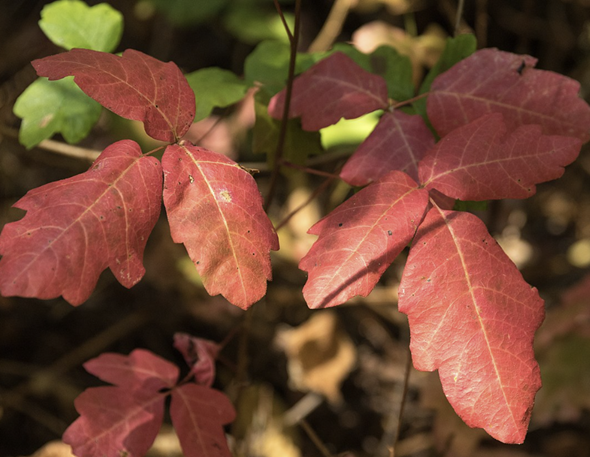
Poison oak (Toxicodendron diversilobum) with fall foliage by Frank Schulenberg

I had my first encounter with poison oak when I was working in a research lab at UC Davis. I had just taken off my gloves after doing an experiment, when I noticed blisters across the back of my hand. Had I spilled acid on my hand? I frantically checked my gloves and work area – no sign of a spill or damage to the gloves. Then I remembered that I had gone hiking near Lake Berryessa a few days earlier. A Google image search confirmed my suspicions – the rash was caused by western poison oak.


Western poison oak is not an oak at all, but is actually a member of the cashew family, which includes cashews, mangos, and sumac. Its closest relatives are the other members of the genus Toxicodendron (Latin for “poison tree”), which includes eastern poison oak, poison ivy, and the Chinese lacquer tree. Western poison oak is the only member of the genus present in California, where it can be found throughout the Coast Ranges, in the Klamath, and at lower elevations in the Sierra Nevada.


Western poison oak takes both its common and species name (Toxicodendron diversilobum) from its lobed leaflets, which resemble oak leaves, except that they typically occur in clusters of three, while true oak leaves are singular. It can occur as either a shrub or a climbing vine and can have quite a bit of variability in the shape of individual leaflets. The key identifying feature is its compound leaves, which each have three leaflets, with the center leaflet having a longer stem. These leaflets begin the year with a green color that will change to red in the fall. The leaves are lost for the winter, during which time the plant can be identified by its reddish-brown stems. It’s important to note that all parts of the plant can cause a rash, so you’ll want to be careful even in the wintertime when it is leafless.


Poison oak and its relatives produce an oil called urushiol, which is rapidly absorbed into our skin upon contact. Once inside our skin, urushiol binds to a protein called CD1a. This causes CD1a to be recognized by the immune system as foreign, leading the immune system to attack the skin cells, eventually causing a blistery rash. Interestingly, CD1a has also been shown to play a key role in causing psoriasis.


Despite the headaches it causes for humans, poison oak is an important component of the ecosystem of the inner coast range, where its leaves provide forage for deer and its berries provide food for a variety of birds. This raises the question of how these animals can contact and consume poison oak without developing rashes like we do. While this question has yet to be definitely answered, the recent discovery CD1a’s role in causing the human reaction to urushiol provides an important clue – the CD1a gene is primarily only found in humans and other primates, suggesting that its absence may contribute to other animal’s lack of sensitivity to urushiol. This is supported by a 2016 study which showed that mice that were genetically engineered to have the CD1a gene became susceptible to urushiol.


Given that there’s not an obvious evolutionary benefit for primates to produce such a strong response to poison oak, you may be wondering “why us?” The answer is unknown, but I suspect that primate sensitivity to urushiol may be an unfortunate evolutionary accident – CD1a likely evolved to recognize other substances similar to urushiol, such as compounds produced by infectious bacteria or fungi, and therefore triggers a defense response when urushiol is present. The good news is that with a better understanding of how the human body reacts to poison oak, scientists may be able to develop more effective treatments. In the meantime, it’s best to keep an eye on your surroundings and remember the mantra “leaves of three, let it be.”


-Dr. Geoff Benn (gbenn@tuleyome.org)


Education Associate

RECENT ARTICLES

By Bryan Pride November 5, 2025
Tuleyome welcomes our first Policy Intern, Diego Barraza. Diego is a Senior at UC Davis studying Environmental Science and Management and is from Santa Barbara, California. Diego will be joining Tuleyome for a 10 week internship to assist with Tuleyome’s policy initiatives, including supporting the work of the Berryessa Snow Mountain National Monument and Molok Luyuk working group coalition and the San Pablo Bay National Wildlife Refuge Expansion Act. We are excited to have Diego join our team and support our policy initiatives!
By Nate Lillge November 5, 2025
The Berryessa Snow Mountain National Monument region has many wonderful trails to explore and enjoy. From urban parks, like American River Bend Park, to trails that help you get away and above it all, like the Berryessa Peak Trail. Do you want to explore on your mountain bike? Head to Fiske Creek and Blue Ridge Trails. Looking for a place to take your horse? The appropriately named Cowboy Camp is the place to go! Ever hiked a volcano? Check out Mount Konocti. Tuleyome’s Trail Guide has guides to nearly 40 trails in the Berryessa Snow Mountain National Monument region and western Sacramento Valley. This is not an exhaustive list but instead provides you with some of our favorite and most popular locations to experience this wonderful and unique location.
By Kristie Ehrhardt November 5, 2025
If you’re a friend of Tuleyome you likely know a bit about our (it belongs to all of us) newly expanded favorite National Monument - the Berryessa Snow Mountain National Monument. You may also recognize that federal public lands are lands that are owned and/or managed by the United States federal government for the enjoyment of its citizens. And, you probably know that in addition to national monuments there are also national parks, national forests and national historic places but did you know that there are many more public land designations as well?! There are many (MANY!) different types of federal public lands. Most of them are held for conservation, resource management and public recreation. The United States Department of the Interior (DOI) oversees several federal agencies that manage various public land designations and the United States Department of Agriculture (USDA) oversees other agencies that steward public lands. Federal public lands in the United States, District of Columbia and US territories total approximately 640 million acres and occupy nearly 30% of the land area. The National Park Service is an agency within the DOI and oversees not only national parks but also most national monuments and other natural, historical and recreational properties with various title designations or units. These include national preserves, national lakeshores and seashores, national rivers and wild and scenic rivers and national scenic and historic trails, among others. Today The National Park Service currently manages 433 combined parks/units including 63 national parks, 87 national monuments, 75 national historic sites, 64 national historic sites and many other designations totaling 85 million acres in all 50 states, the District of Columbia and US territories. Their management focus is preserving the ecological and historical integrity of these special places for public use and enjoyment. The Bureau of Land Management (BLM) is a federal agency also under the direction of the DOI. The BLM’s mission is “to sustain the health, diversity and productivity of public lands for the use and enjoyment of present and future generations.” We here at Tuleyome think that’s pretty dang good and we often partner with them on varying components of public land use and enjoyment. The BLM is responsible for the management of a substantial portion of the nation’s public lands including some of our most historic and scenic landscapes and natural resources for all to enjoy. The United States Fish and Wildlife Service (USFWS) is another agency operated under the DOI and is the oldest conservation agency in the United States. It was established in 1871 to help monitor the country’s game fish populations. Today the USFWS manages our nation’s wildlife refuges to conserve the habitat, plants and wildlife found there. The national wildlife refuge system began with Pelican Island in 1903 and today there are over 560 refuges across the country. It’s been said that if “national parks are America’s best idea, national wildlife refuges are America’s best-kept secret”. Although, they don’t seem like a very stealthy secret since they receive over 50 million visitors a year! The United States Forest Service (USFS) was established in 1905 and is an agency under the USDA. It is the United States’ predominant forestry agency leading the world in sustainable forest and grassland use, management and stewardship, research and conservation. Today they are responsible for the management of 154 national forests and surrounding areas that total nearly 200 million acres in 43 states, the Virgin Islands and Puerto Rico. The agency also provides stewardship assistance to tribal, state and local governments, private landowners and corporations to improve conditions on about 900 million acres of forests in the U.S. Fun fact - Yellowstone was the United States’ first national park established in 1872. But, at the time Wyoming was still a U.S. territory so Yellowstone was managed by the federal government using the Army and the African American Buffalo Soldiers. Fun fact - the designation National Monument has been given to many different sites ranging from natural reserves, historic military scenes, prehistoric ruins, fossil sites AND to the Statue of Liberty. Fun fact - there is at least one national wildlife refuge in every US state and territory. Fun fact - The Forest Service obviously manages forests but did you know that they also manage grasslands? Did you know… that the Berryessa Snow Mountain National Monument is jointly managed by both the BLM and the USFS, not the National Park Service!? Whether you’re exploring places where you won’t find a motorized vehicle or places where you might not find a parking spot, you can bet there is at least one type of federal public land just a hop, skip and a jump from you! The numerous designations within the National Park System sometimes confuse visitors. The names are created in the Congressional legislation authorizing the sites or by the president, who proclaims "national monuments" under the Antiquities Act of 1906. Many names are descriptive—lakeshores, seashores, battlefields—but others cannot be neatly categorized because of the diversity of resources within them. In 1970, Congress elaborated on the 1916 National Park Service Organic Act, saying all units of the system have equal legal standing in a national system. National Park These are generally large natural places having a wide variety of attributes, at times including significant historic assets. Hunting, mining and consumptive activities are not authorized. National Monument The Antiquities Act of 1906 authorized the President to declare by public proclamation landmarks, structures, and other objects of historic or scientific interest situated on lands owned or controlled by the government to be national monuments. National Preserve National preserves are areas having characteristics associated with national parks, but in which Congress has permitted continued public hunting, trapping, oil/gas exploration and extraction. Many existing national preserves, without sport hunting, would qualify for national park designation. National Historic Site Usually, a national historic site contains a single historical feature that was directly associated with its subject. Derived from the Historic Sites Act of 1935, a number of historic sites were established by secretaries of the Interior, but most have been authorized by acts of Congress. National Historical Park This designation generally applies to historic parks that extend beyond single properties or buildings. National Memorial A national memorial is commemorative of a historic person or episode; it need not occupy a site historically connected with its subject. National Battlefield This general title includes national battlefield, national battlefield park, national battlefield site, and national military park. In 1958, an NPS committee recommended national battlefield as the single title for all such park lands. National Cemetery There are presently 14 national cemeteries in the National Park System, all of which are administered in conjunction with an associated unit and are not accounted for separately. National Recreation Area Twelve NRAs in the system are centered on large reservoirs and emphasize water-based recreation. Five other NRAs are located near major population centers. Such urban parks combine scarce open spaces with the preservation of significant historic resources and important natural areas in location that can provide outdoor recreation for large numbers of people. National Seashore Ten national seashores have been established on the Atlantic, Gulf and Pacific coasts; some are developed and some relatively primitive. Hunting is allowed at many of these sites. National Lakeshore National lakeshores, all on the Great Lakes, closely parallel the seashores in character and use. National River There are several variations to this category: national river and recreation area, national scenic river, wild river, etc. The first was authorized in 1964 and others were established following passage of the Wild and Scenic Rivers Act of 1968. National Parkway The title parkway refers to a roadway and the parkland paralleling the roadway. All were intended for scenic motoring along a protected corridor and often connect cultural sites. National Trail National scenic trails and national historic trails are the titles given to these linear parklands (over 3,600 miles) authorized under the National Trails System Act of 1968. Affiliated Areas In an Act of August 18, 1970, the National Park System was defined in law as, "any area of land and water now or hereafter administered by the Secretary of the Interior through the National Park Service for park, monument, historic, parkway, recreational or other purposes." The Affiliated Areas comprise a variety of locations in the United States and Canada that preserve significant properties outside the National Park System. Some of these have been recognized by Acts of Congress, others have been designated national historic sites by the Secretary of the Interior under authority of the Historic Sites Act of 1935. All draw on technical or financial aid from the National Park Service. Other Designations Some units of the National Park System bear unique titles or combinations of titles, like the White House and Prince William Forest Park . Types of federal public lands National Parks : Managed by the National Park Service (NPS), these lands are preserved for their natural and cultural resources for future generations to enjoy. National Forests and Grasslands : Managed by the U.S. Forest Service (USFS), these areas are used for multiple purposes, including timber, recreation, and wildlife management. National Wildlife Refuges : Managed by the U.S. Fish and Wildlife Service (USFWS), these lands are primarily for the conservation of fish, wildlife, and plants, but many also allow compatible wildlife-dependent recreation like hunting and fishing. National Conservation Lands : These are public lands designated for their conservation value and are managed by the Bureau of Land Management (BLM). The BLM manages more public land acreage than any other agency. Management and use Management: Federal lands are managed by various agencies, with the U.S. Forest Service (Department of Agriculture) and the Bureau of Land Management, the National Park Service, and the U.S. Fish and Wildlife Service (all under the Department of the Interior) being the primary ones. Resource Extraction: Some federal lands are available for resource extraction like oil, gas, and mining, which can be a source of controversy and debate over conservation versus extraction. Recreation: The lands offer a wide range of recreational opportunities, such as hiking, camping, wildlife viewing, hunting, and fishing. Information: You can find information about specific public lands, including maps and regulations, on the official websites of the managing agencies.