KEEP USDA SERVICES IN CALIFORNIA

500 MILES TOO FAR!

USDA REORGANIZATION

On July 24, 2025, the United States Department of Agriculture (USDA) released a plan to reorganize its offices nationwide. The reorganization affects multiple USDA agencies that serve California's farmers, ranchers, rural communities and national forests, consolidating operations into five regional hubs while eliminating the current nine regional Forest Service offices across the country. The closest hub to California will be located in Salt Lake City, Utah - over 500 miles from the Central Valley.

What's at Stake for California

AGRICULTURAL SECTOR UNDER THREAT

California dominates American agriculture with $59.46 billion in agricultural sales and more than 400 agricultural commodities. California produces 70% of all fruits and vegetables grown in the country. Despite this agricultural supremacy, the USDA reorganization threatens this leadership by:

  • Excluding California representation

    The five new regional hubs are located in Raleigh NC, Kansas City MO, Indianapolis IN, Fort Collins CO, and Salt Lake City UT - none in California despite it being the nation's top agricultural producer

  • Disrupting county services

    Local USDA offices may close or reduce services, affecting farmers' access to technical assistance and emergency response coordination

  • Centralizing nutrition programs

    The Food and Nutrition Service will reduce its regions from seven to five and align with distant USDA hubs, which could affect how SNAP, WIC, and school nutrition programs are administered in California's 58 counties

  • Consolidating agricultural services

    USDA will consolidate support functions away from California, reducing responsiveness to the state's diverse agricultural, environmental and resource challenges

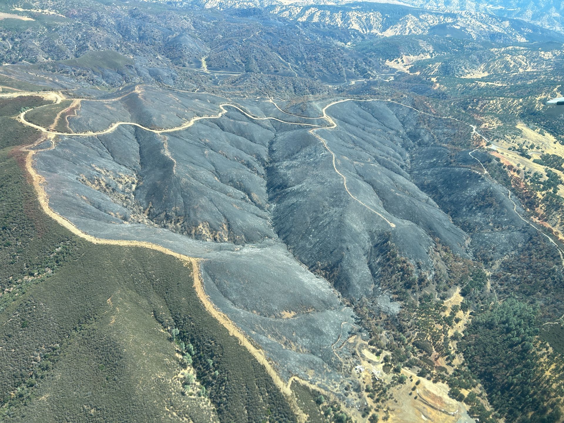
FOREST MANAGEMENT AND WILDFIRE RESPONSE IN JEOPARDY

California’s 18 national forests covering 20 million acres will be managed from distant states with far less forest land and far different ecosystems. The reorganization plan:

  • Closes Forest Service regional offices over the next year

    including California's Region 5 office that oversees California, Hawaii and Pacific Islands

  • Eviscerates the experienced workforce

    Over 15,000 USDA employees have taken voluntary buyouts, and the reorganization accelerates departures as employees face relocation and elimination of positions

  • Removes local decision-making

    thousands of miles from California's fire-prone forests, removing decision-making authority from those with expertise and slowing emergency response

  • Shutters California's Pacific Southwest Research Station

    The only research station studying Mediterranean climate and chaparral ecosystems moves to Colorado, losing expertise tailored to California's unique conditions

ECONOMIC IMPACT ON CALIFORNIA COMMUNITIES

California's rural communities and agricultural economy will bear significant economic costs from the reorganization

  • Displaces workers

    California USDA employees face forced relocation to distant states or job loss

  • Removes local expertise

    Decades of California-specific agricultural and forestry knowledge will be lost

  • Slows agriculture inspections

    Consolidation of support functions may slow critical food safety inspections for California's massive agricultural exports

  • Eliminates rural community support

    Loss of federal presence in rural California communities that depend on USDA and USFS services

HOW TO TAKE ACTION

California cannot afford to lose its voice in USDA decision-making. Act now by sending a letter to USDA to express why it is imperative that regional offices exist to better serve our community.


Submit your comments today! Deadline: August 26, 2025

Email your comments to: reorganization@usda.gov

SAMPLE EMAIL:


"I oppose the USDA reorganization plan because it fails to adequately serve California's needs. As the nation's leading agricultural producer with $59.46 billion in sales - California requires dedicated regional oversight, not distant management from other states. The elimination of Forest Service regional offices puts California communities at risk during fire season and threatens the health of our public lands. The consolidation of county-level services threatens nutrition programs, agricultural assistance, and emergency response that California's 58 counties depend on. This plan was developed without proper consultation with communities, land managers or agricultural stakeholders. I urge USDA to maintain a California-based regional hub, maintain Forest Service regional offices, and ensure continued local service delivery to protect our state's agricultural economy, wildfire response capabilities, public lands and rural communities."

You have until August 26, 2025 to submit comments opposing this plan that abandons California and the West Coast.


For more information contact Bryan Pride, Tuleyome's Policy Director.

RECENT NEWS

By Nate Lillge August 6, 2025
Bill Grabert is stepping down from his position as treasurer on Tuleyome’s volunteer Board of Directors – we thank him for his many years of service! Bill first joined Tuleyome as a staff member in 2016. His nature-based teaching influenced many youth over the years with school field trips throughout the Berryessa Snow Mountain National Monument region, from Redbud Trail to Conaway Ranch. As part of Tuleyome’s team of instructors for the California Certified Naturalist program, Bill inspired adults to care for the region. His love of the area began as soon as he graduated from college and began working as a geologist in Lake County. Bill has devoted his diverse knowledge and skillset to care for, steward, and enjoy California’s northern Inner Coast Range Mountains for many years. He will be missed on the Board but we look forward to seeing him on the trails! -Nate Lillge (Adventures and Engagement Director)  and Lyndsay Dawkins (Volunteer Tuleyome Board President)
By Bryan Pride August 6, 2025
Fifty-eight and a half million acres of America's wildest forests have been protected for nearly 25 years by the Roadless Rule, a conservation cornerstone that could soon disappear. Established in 2001, the Roadless Area Conservation Rule (RACR) , more commonly known as the Roadless Rule, designated "Inventoried Roadless Areas" (IRAs) across our nation's forests, prohibiting new roads from being built. Now, USDA Secretary Rollins wants to rescind it . From Alaska to California, the losses from this rollback would be massive. In Alaska, 92% of the Tongass National Forest could lose protection, threatening one of the world's most pristine ecosystems and the indigenous communities who call it home. California would lose protections across 4.4 million acres spanning 21 national forests , which has the potential to impact treasured places like Inyo, Shasta-Trinity, and the Berryessa Snow Mountain National Monument. Rule Born from Necessity, Not Ideology The Roadless Rule traces back to 1998, when U.S. Forest Service Chief Mike Dombeck saw the agency's vast road system as a major environmental and fiscal problem . To put this in perspective: the Forest Service maintains eight times more miles of road than the Interstate Highway System. The agency had too many roads to properly maintain for safety and environmental purposes, with poorly maintained roads contributing to erosion and other harms across national forests. The road maintenance backlog had ballooned to $8.4 billion while the agency received only 20% of the funding needed to maintain roads to environmental and safety standards. Dombeck proposed a moratorium on road construction in undeveloped forest areas across most of the National Forest System. The agency adopted an 18-month moratorium in February 1999 pending completion of an overall road management plan. Later that year, the agency undertook a rule making process to provide long-term administrative protection for roadless areas. The Forest Service conducted an extensive public involvement process that produced 1.7 million comments , with the majority favoring a strong national policy protecting roadless areas. The resulting Roadless Rule was not and is still not a blanket ban: it makes exceptions to allow access to non-federal land inholdings and pre-existing mineral leases, and allows logging to reduce fire risk, improve habitat or aid in the recovery of endangered species. What began as a fiscally prudent solution to an unwieldy road network became a cornerstone of forest conservation, one that Americans overwhelmingly supported then and continue to support today. The Administration's Claims vs. Reality According to USDA Secretary Rollins , the rule is “overly restrictive”, hinders fire prevention and responsible timber production, therefore the Rule poses “real harm to millions of acres of our national forests.” Rollins linked rescinding the Rule with Presidential Executive Order 14192, "Unleashing Prosperity Through Deregulation .” The reality is different. Rollins' claim ignores what's actually at stake. Roadless areas are essential ecosystems that provide clean air and water while keeping wilderness intact. They also serve as critical refuges for wildlife; 57% of America's most vulnerable species depend on roadless areas for habitat. For the 156 million Americans who visit national forests annually, these areas offer irreplaceable backcountry recreation experiences. Most strikingly, the administration's fire prevention argument is backwards. Scientific research reveals that 88% of wildfires are human-caused , and 95% of these fires start within half a mile of a road. Areas closest to roads experience 53% more fires than would occur by random chance. Less than 3% of wildfires start in wilderness areas more than a mile from roads. This research indicates that more roads through our forests are more likely to increase fires and would outweigh the effects of improving fire containment. While the administration claims roads improve fire response, fire management teams consistently identify inadequate resources and personnel shortages, not roads , as the primary barriers to effective wildfire management . Rather than building roads that increase fire risk, fire management experts advocate for investing in cultural and prescribed burns, fire mitigation and forest restoration, proven approaches that are underfunded but key to preventing future fires and reducing fire magnitude. What's Next? Rescinding the Roadless Rule will require a public comment period that has yet to be announced. This is when we can all share our views. Tuleyome will be following this issue closely and will be commenting. For more information on the Roadless Rule and how to participate in the public comment process or other advocacy opportunities, contact B ryan Pr ide .
By Kristie Ehrhardt August 6, 2025
The short answer is honestly, pretty much anywhere! Because the 344,476 acre Berryessa Snow Mountain National Monument (the Monument) is located in the rural areas of Colusa, Glenn, Lake, Mendocino, Napa, Solano and Yolo counties you will have a great view of the dark night sky, free from urban light pollution from virtually anywhere within its boundaries! The Monument is an easy drive from not only the metropolitan Sacramento area but also from the San Francisco Bay Area as well as the North Bay communities making it an easy day trip. If you’re here especially for the Perseid meteor shower though it might be a very long day since best viewing happens between the hours of midnight and early morning. If you’re adventurous and up for an all-nighter, be certain to pack plenty of water and snacks and be sure to pull over only where it is safe and you’re not blocking a road, especially when it’s dark. Also always keep safety in mind and look out for wildlife as the Monument is home to black bears, mountain lions, coyotes, tule elk and bobcats that may be traveling through the area as well. If you’d like to stay a night (or several), there are multiple developed campgrounds to choose from inside the Monument boundaries. If you’re up camping, check out The Blue Oaks Campground, Indian Valley Campground, Hunting Creek Campground, Deer Valley Campground, Lower Nye Campground, West Crocket Campground or Kowalski Camping area just to name a few of the sites available for overnight stays. Before you go though, please do check with the United States Forest Service or the Bureau of Land Management websites for details on the particular camping area you’re interested in as well as current conditions, requirements and fire restrictions. The Monument also offers primitive camping in the three wilderness areas located within the Monument boundaries. Cache Creek Wilderness, Cedar Roughs Wilderness and Snow Mountain Wilderness present nearly unlimited opportunities for dispersed camping or backcountry camping (areas located outside of designated campgrounds). Although camping is allowed and encouraged, these areas have no amenities such as tables, toilets, available water or waste removal and require you to pack out all trash and waste. There are no motorized vehicles allowed within Wilderness areas and they provide places for deep solitude with nature. Camping in Wilderness areas or other dispersed camping areas require visitors to understand and follow the Leave No Trace principles of outdoor recreating as well as planning ahead and knowing the area and what to pack. That said, other than the trees potentially blocking some of the night sky, you’re sure to avoid urban light pollution and have an unobstructed view of the night sky from practically anywhere within the Monument! -Kristie Ehrhardt ( kehrhardt@tuleyome.org ) Tuleyome Land Conservation Program Manager