Monumental Questions - What is the Blue Ridge Berryessa Natural Area?

Kristie Ehrhardt • November 9, 2021

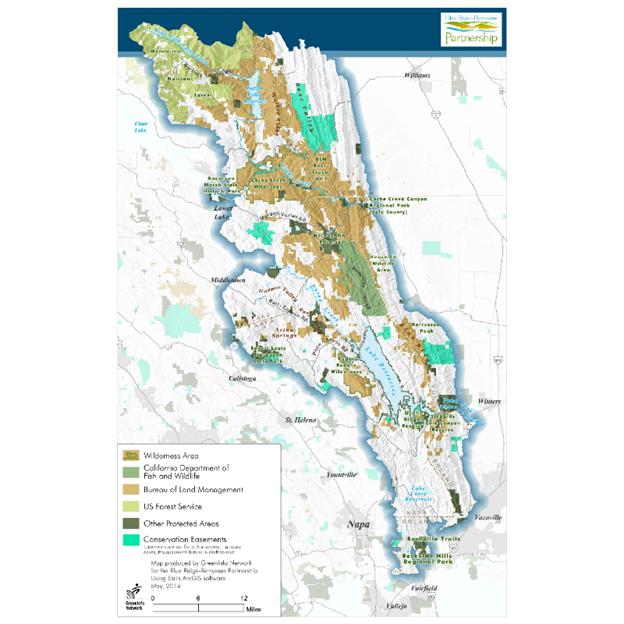
The Blue Ridge – Berryessa Natural Area (BRBNA) is a conservation area composed of nearly 800,000 acres of land located roughly 90 miles west of Sacramento and about 100 miles northeast of San Francisco. It extends from just north of Interstate 80 near the town of Fairfield, north to the southern edge of the Mendocino National Forest and encompasses much of the Inner Coastal Range. Although the boundaries of the Blue Ridge – Berryessa Natural Area are conceptual and informal, they do include some of the acreage within the Berryessa Snow Mountain National Monument.


The Blue Ridge – Berryessa Natural Area was named for two locally prominent features, the Blue Ridge Mountains and Lake Berryessa, and includes portions of Napa, Yolo, Solano, Lake and Colusa Counties. It includes both privately owned land as well as federal, state and local public recreation land. The area is relatively undisturbed by development encroachment and existing land uses include private ranches and a few small, locally owned businesses as well as land trust protected preserves and easements. The University of California’s Natural Reserve System owns and manages three reserves located in the Blue Ridge – Berryessa Natural Area including McLaughlin Reserve, Quail Ridge Reserve and Stebbins Cold Canyon Reserve. These reserves are dedicated to a broad array of research and educational opportunities including wild turkey and ringtail studies, plant ecology, wildlife biology, Lyme disease studies, geology, soils and more.


The Blue Ridge – Berryessa Natural Area supports many habitat types including serpentine, chamise and lower montane chaparral, oak woodlands, valley and foothill grasslands and mixed riparian woodland. Wildlife species found in the area include large mammals such as mountain lion, black bear, coyote, bobcat and deer. Other species observed include ringtails, raccoons, turkeys, many reptiles and amphibians and native fish including the Sacramento Roach and the California Pike Minnow. Over 100 species of birds including Bald and Golden Eagle have also been documented. The Blue Ridge – Berryessa Natural Area also supports habitat for several endemic plant species that occur only on serpentine soils found here. Because of the diversity of species and habitat types, the region has been recognized as one of the most diverse areas in California. Recreational opportunities include wildlife viewing, hiking, rafting, horseback riding, nature camping, photography, and hunting.


The area is overseen by the Blue Ridge Berryessa Natural Area Conservation Partnership. With over 100 participants ranging from privately owned ranches, nonprofits, county, state and federal agencies; the focus of the partnership is to preserve recreational lands, wild areas, agricultural lands and rural ranches through conservation easements and public ownership. In 2002, the Partnership received the California Governor’s Environmental and Economic Leadership Award.


Kristie Ehrhardt; (kehrhardt@tuleyome.org)


Land Conservation and Stewardship Program Director


If you have questions about Berryessa Snow Mountain National Monument that you would like us to address, please email them to Nate Lillge (nlillge@tuleyome.org) or Kristie Ehrhardt (kehrhardt@tuleyome.org). More information can be found

at www.berryessasnowmountain.org.


RECENT ARTICLES

By Nate Lillge August 6, 2025
Bill Grabert is stepping down from his position as treasurer on Tuleyome’s volunteer Board of Directors – we thank him for his many years of service! Bill first joined Tuleyome as a staff member in 2016. His nature-based teaching influenced many youth over the years with school field trips throughout the Berryessa Snow Mountain National Monument region, from Redbud Trail to Conaway Ranch. As part of Tuleyome’s team of instructors for the California Certified Naturalist program, Bill inspired adults to care for the region. His love of the area began as soon as he graduated from college and began working as a geologist in Lake County. Bill has devoted his diverse knowledge and skillset to care for, steward, and enjoy California’s northern Inner Coast Range Mountains for many years. He will be missed on the Board but we look forward to seeing him on the trails! -Nate Lillge (Adventures and Engagement Director)  and Lyndsay Dawkins (Volunteer Tuleyome Board President)
By Bryan Pride August 6, 2025
Fifty-eight and a half million acres of America's wildest forests have been protected for nearly 25 years by the Roadless Rule, a conservation cornerstone that could soon disappear. Established in 2001, the Roadless Area Conservation Rule (RACR) , more commonly known as the Roadless Rule, designated "Inventoried Roadless Areas" (IRAs) across our nation's forests, prohibiting new roads from being built. Now, USDA Secretary Rollins wants to rescind it . From Alaska to California, the losses from this rollback would be massive. In Alaska, 92% of the Tongass National Forest could lose protection, threatening one of the world's most pristine ecosystems and the indigenous communities who call it home. California would lose protections across 4.4 million acres spanning 21 national forests , which has the potential to impact treasured places like Inyo, Shasta-Trinity, and the Berryessa Snow Mountain National Monument. Rule Born from Necessity, Not Ideology The Roadless Rule traces back to 1998, when U.S. Forest Service Chief Mike Dombeck saw the agency's vast road system as a major environmental and fiscal problem . To put this in perspective: the Forest Service maintains eight times more miles of road than the Interstate Highway System. The agency had too many roads to properly maintain for safety and environmental purposes, with poorly maintained roads contributing to erosion and other harms across national forests. The road maintenance backlog had ballooned to $8.4 billion while the agency received only 20% of the funding needed to maintain roads to environmental and safety standards. Dombeck proposed a moratorium on road construction in undeveloped forest areas across most of the National Forest System. The agency adopted an 18-month moratorium in February 1999 pending completion of an overall road management plan. Later that year, the agency undertook a rule making process to provide long-term administrative protection for roadless areas. The Forest Service conducted an extensive public involvement process that produced 1.7 million comments , with the majority favoring a strong national policy protecting roadless areas. The resulting Roadless Rule was not and is still not a blanket ban: it makes exceptions to allow access to non-federal land inholdings and pre-existing mineral leases, and allows logging to reduce fire risk, improve habitat or aid in the recovery of endangered species. What began as a fiscally prudent solution to an unwieldy road network became a cornerstone of forest conservation, one that Americans overwhelmingly supported then and continue to support today. The Administration's Claims vs. Reality According to USDA Secretary Rollins , the rule is “overly restrictive”, hinders fire prevention and responsible timber production, therefore the Rule poses “real harm to millions of acres of our national forests.” Rollins linked rescinding the Rule with Presidential Executive Order 14192, "Unleashing Prosperity Through Deregulation .” The reality is different. Rollins' claim ignores what's actually at stake. Roadless areas are essential ecosystems that provide clean air and water while keeping wilderness intact. They also serve as critical refuges for wildlife; 57% of America's most vulnerable species depend on roadless areas for habitat. For the 156 million Americans who visit national forests annually, these areas offer irreplaceable backcountry recreation experiences. Most strikingly, the administration's fire prevention argument is backwards. Scientific research reveals that 88% of wildfires are human-caused , and 95% of these fires start within half a mile of a road. Areas closest to roads experience 53% more fires than would occur by random chance. Less than 3% of wildfires start in wilderness areas more than a mile from roads. This research indicates that more roads through our forests are more likely to increase fires and would outweigh the effects of improving fire containment. While the administration claims roads improve fire response, fire management teams consistently identify inadequate resources and personnel shortages, not roads , as the primary barriers to effective wildfire management . Rather than building roads that increase fire risk, fire management experts advocate for investing in cultural and prescribed burns, fire mitigation and forest restoration, proven approaches that are underfunded but key to preventing future fires and reducing fire magnitude. What's Next? Rescinding the Roadless Rule will require a public comment period that has yet to be announced. This is when we can all share our views. Tuleyome will be following this issue closely and will be commenting. For more information on the Roadless Rule and how to participate in the public comment process or other advocacy opportunities, contact B ryan Pr ide .
By Kristie Ehrhardt August 6, 2025
The short answer is honestly, pretty much anywhere! Because the 344,476 acre Berryessa Snow Mountain National Monument (the Monument) is located in the rural areas of Colusa, Glenn, Lake, Mendocino, Napa, Solano and Yolo counties you will have a great view of the dark night sky, free from urban light pollution from virtually anywhere within its boundaries! The Monument is an easy drive from not only the metropolitan Sacramento area but also from the San Francisco Bay Area as well as the North Bay communities making it an easy day trip. If you’re here especially for the Perseid meteor shower though it might be a very long day since best viewing happens between the hours of midnight and early morning. If you’re adventurous and up for an all-nighter, be certain to pack plenty of water and snacks and be sure to pull over only where it is safe and you’re not blocking a road, especially when it’s dark. Also always keep safety in mind and look out for wildlife as the Monument is home to black bears, mountain lions, coyotes, tule elk and bobcats that may be traveling through the area as well. If you’d like to stay a night (or several), there are multiple developed campgrounds to choose from inside the Monument boundaries. If you’re up camping, check out The Blue Oaks Campground, Indian Valley Campground, Hunting Creek Campground, Deer Valley Campground, Lower Nye Campground, West Crocket Campground or Kowalski Camping area just to name a few of the sites available for overnight stays. Before you go though, please do check with the United States Forest Service or the Bureau of Land Management websites for details on the particular camping area you’re interested in as well as current conditions, requirements and fire restrictions. The Monument also offers primitive camping in the three wilderness areas located within the Monument boundaries. Cache Creek Wilderness, Cedar Roughs Wilderness and Snow Mountain Wilderness present nearly unlimited opportunities for dispersed camping or backcountry camping (areas located outside of designated campgrounds). Although camping is allowed and encouraged, these areas have no amenities such as tables, toilets, available water or waste removal and require you to pack out all trash and waste. There are no motorized vehicles allowed within Wilderness areas and they provide places for deep solitude with nature. Camping in Wilderness areas or other dispersed camping areas require visitors to understand and follow the Leave No Trace principles of outdoor recreating as well as planning ahead and knowing the area and what to pack. That said, other than the trees potentially blocking some of the night sky, you’re sure to avoid urban light pollution and have an unobstructed view of the night sky from practically anywhere within the Monument! -Kristie Ehrhardt ( kehrhardt@tuleyome.org ) Tuleyome Land Conservation Program Manager